Maps of Chodouny

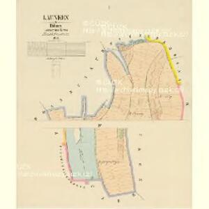
Launken - c4257-1-003 - Kaiserpflichtexemplar der Landkarten des stabilen Katasters
1 : 2880
Launken - c4257-1-001 - Kaiserpflichtexemplar der Landkarten des stabilen Katasters
1 : 2880
Launken - c4257-1-002 - Kaiserpflichtexemplar der Landkarten des stabilen Katasters
1 : 2880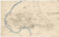
Das Laager zwischen Raudnitz und Gasdorff welches den 13ten Jully [1]778 bezochen [sic] worden
1 : 13600 Roudnice nad Labem-oblast (Česko)
Chodom - c2552-1-002 - Kaiserpflichtexemplar der Landkarten des stabilen Katasters
1 : 2880
Chodom - c2552-1-004 - Kaiserpflichtexemplar der Landkarten des stabilen Katasters
1 : 2880
Chodom - c2552-1-001 - Kaiserpflichtexemplar der Landkarten des stabilen Katasters
1 : 2880
Chodom - c2552-1-003 - Kaiserpflichtexemplar der Landkarten des stabilen Katasters
1 : 2880
Gross Nutschnitz - c5326-1-001 - Kaiserpflichtexemplar der Landkarten des stabilen Katasters
1 : 2880
Gross Nutschnitz - c5326-1-002 - Kaiserpflichtexemplar der Landkarten des stabilen Katasters
1 : 2880
Liboteinitz (Libotenice) - c4046-1-001 - Kaiserpflichtexemplar der Landkarten des stabilen Katasters
1 : 2880
Liboteinitz (Libotenice) - c4046-1-002 - Kaiserpflichtexemplar der Landkarten des stabilen Katasters
1 : 2880
Liboteinitz (Libotenice) - c4046-1-003 - Kaiserpflichtexemplar der Landkarten des stabilen Katasters
1 : 2880
Liboteinitz (Libotenice) - c4046-1-004 - Kaiserpflichtexemplar der Landkarten des stabilen Katasters
1 : 2880
Czernowes - c0886-1-002 - Kaiserpflichtexemplar der Landkarten des stabilen Katasters
1 : 2880
Czernowes - c0886-1-001 - Kaiserpflichtexemplar der Landkarten des stabilen Katasters
1 : 2880
Czernowes - c0886-1-003 - Kaiserpflichtexemplar der Landkarten des stabilen Katasters
1 : 2880
[Židovice]
Hrobce (Česko)
[Plan der Gegend zwischen Tursko und Theresienstadt]
1 : 61500 Litoměřice-oblast (Česko)
III. vojenské mapování 3852/2
1 : 25000
Gradkartenblatt
1 : 25000 Roudnice nad Labem-oblast (Česko) Bellschan, Anton
Půdní mapa okresu Roudnice nad Labem


Bodenkarte des Bezirkes Raudnitz a. d. E
1 : 46000 Roudnice nad Labem-oblast (Česko) Janovský, Josef reprodukce zeměpisného ústavu min. vnitra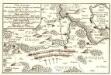
Lager der Kaÿserl. Königl. Ungarischen Armée beÿ Budin in Böhmen vor der Schlacht beÿ Lowositz Anno 1756
Mollova mapová sbírka Fridrich, Jacob Andreas Friedrich, Jacob Andreas
Raudnitz und Jungferteinitz
1 : 75000 Roudnice nad Labem (Česko : oblast) Ahl K. u. k. militär-geographisches Institut
Raudnitz und Jungferteinitz
1 : 75000 Roudnice nad Labem (Česko : oblast) Ahl K. u. k. Militärgeographisches Institut
Raudnitz und Jungferteinitz
1 : 75000 Roudnice nad Labem (Česko : oblast) K. u. k. Militärgeographisches Institut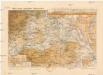
Mapa okres. hejtmanství Roudnického
1 : 100000 Budyně nad Ohří-oblast (Česko) R. Kaška