Maps of Štětí


Půdní mapa okresu Roudnice nad Labem

Bodenkarte des Bezirkes Raudnitz a. d. E
1 : 46000 Roudnice nad Labem-oblast (Česko) Janovský, Josef reprodukce zeměpisného ústavu min. vnitra
III. vojenské mapování 3853/1
1 : 25000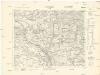
[Kartenblatt]
1 : 25000 Kokořín (Česko : oblast) Reichsamt für Landesaufnahme
Gradkartenblatt
1 : 25000 Roudnice nad Labem-oblast (Česko) Bellschan, Anton
III. vojenské mapování 3853/1
1 : 25000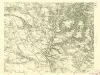
III. vojenské mapování 3853/1
1 : 25000
[Kartenblatt]
1 : 25000 Brozany nad Ohří (Česko) Reichsamt für Landesaufnahme
III. vojenské mapování 3852/2
1 : 25000
Hydrografische Uibersichtskarte der Flüsse, Bäche und sonstigen Gewässer im Königreiche Boehmen
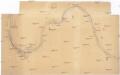
[Labe v okolí Roudnice]
Labe-tok dolní (Německo)
Lager zwischen Raudnitz und Gastorf
1 : 60000 Roudnice nad Labem (Česko : oblast)
Lager in der Gegend vom Georgen-Berg
1 : 100000 Říp (Česko : hora : oblast)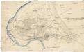
Das Laager zwischen Raudnitz und Gasdorff welches den 13ten Jully [1]778 bezochen [sic] worden
1 : 13600 Roudnice nad Labem-oblast (Česko)
Raudnitz (Raudnice) - c6559-1-007 - Kaiserpflichtexemplar der Landkarten des stabilen Katasters
1 : 2880
Raudnitz (Raudnice) - c6559-1-004 - Kaiserpflichtexemplar der Landkarten des stabilen Katasters
1 : 2880
Raudnitz (Raudnice) - c6559-1-005 - Kaiserpflichtexemplar der Landkarten des stabilen Katasters
1 : 2880
Raudnitz (Raudnice) - c6559-1-006 - Kaiserpflichtexemplar der Landkarten des stabilen Katasters
1 : 2880
Raudnitz (Raudnice) - c6559-1-003 - Kaiserpflichtexemplar der Landkarten des stabilen Katasters
1 : 2880
Raudnitz (Raudnice) - c6559-1-008 - Kaiserpflichtexemplar der Landkarten des stabilen Katasters
1 : 2880
Raudnitz (Raudnice) - c6559-1-001 - Kaiserpflichtexemplar der Landkarten des stabilen Katasters
1 : 2880
Raudnitz (Raudnice) - c6559-1-002 - Kaiserpflichtexemplar der Landkarten des stabilen Katasters
1 : 2880
Podczap - c2120-1-006 - Kaiserpflichtexemplar der Landkarten des stabilen Katasters
1 : 2880
Podczap - c2120-1-007 - Kaiserpflichtexemplar der Landkarten des stabilen Katasters
1 : 2880
Podczap - c2120-1-001 - Kaiserpflichtexemplar der Landkarten des stabilen Katasters
1 : 2880
Podczap - c2120-1-004 - Kaiserpflichtexemplar der Landkarten des stabilen Katasters
1 : 2880
Podczap - c2120-1-005 - Kaiserpflichtexemplar der Landkarten des stabilen Katasters
1 : 2880
Podczap - c2120-1-002 - Kaiserpflichtexemplar der Landkarten des stabilen Katasters
1 : 2880


