Maps of Dolní Měcholupy

Ober Miecholup - c2099-1-001 - Kaiserpflichtexemplar der Landkarten des stabilen Katasters
1 : 2880
Ober Miecholup - c2099-1-002 - Kaiserpflichtexemplar der Landkarten des stabilen Katasters
1 : 2880
Unter Miecholup (Dolno Mecholupi) - c1341-1-002 - Kaiserpflichtexemplar der Landkarten des stabilen Katasters
1 : 2880
Unter Miecholup (Dolno Mecholupi) - c1341-1-001 - Kaiserpflichtexemplar der Landkarten des stabilen Katasters
1 : 2880
Unter Miecholup (Dolno Mecholupi) - c1341-1-003 - Kaiserpflichtexemplar der Landkarten des stabilen Katasters
1 : 2880
Orientační plán hlavního města Prahy s okolím

Petrowitz (Petrowice) - c5734-1-001 - Kaiserpflichtexemplar der Landkarten des stabilen Katasters
1 : 2880
Petrowitz (Petrowice) - c5734-1-002 - Kaiserpflichtexemplar der Landkarten des stabilen Katasters
1 : 2880
Výškopisný plán hlavního města Prahy s okolím

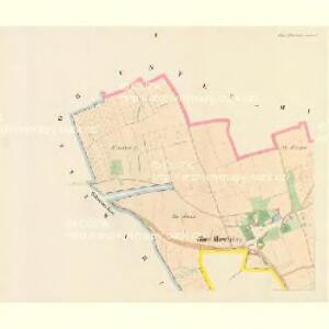
Hostiwarz (Hostiwarze) - c2250-1-004 - Kaiserpflichtexemplar der Landkarten des stabilen Katasters
1 : 2880
Hostiwarz (Hostiwarze) - c2250-1-005 - Kaiserpflichtexemplar der Landkarten des stabilen Katasters
1 : 2880
Hostiwarz (Hostiwarze) - c2250-1-003 - Kaiserpflichtexemplar der Landkarten des stabilen Katasters
1 : 2880
Hostiwarz (Hostiwarze) - c2250-1-006 - Kaiserpflichtexemplar der Landkarten des stabilen Katasters
1 : 2880
Hostiwarz (Hostiwarze) - c2250-1-001 - Kaiserpflichtexemplar der Landkarten des stabilen Katasters
1 : 2880
Hostiwarz (Hostiwarze) - c2250-1-002 - Kaiserpflichtexemplar der Landkarten des stabilen Katasters
1 : 2880
Umgebung von Prag
Umgebung von Prag IV.

Výškopisný plán hlavního města Prahy s okolím

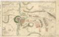
Bataille de Prague
1 : 62300 Praha (Česko) Therbu Coentgen, Heinrich Hugo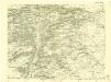
III. vojenské mapování 3953/3
1 : 25000
Bez titulu: Jihovýchodní okolí Prahy

[Praha a okolí]
Praha-oblast (Česko)
Mapa politického a školního okresu Karlínského

[Gradkartenblatt]
1 : 25000 Praha (Česko : oblast) Vojenský zeměpisný ústav
Plán velké Prahy
1 : 19000 Praha (Česko) Grgurič, Václav Sádlo, Jiří A. Storch syn
Městské podniky Pražské

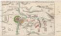
Accurate Vorstellung der zwischen den oesterreichischen und preussischen Armeen geschehenen Bataille bey Prag, den 6. May 1757
Praha (Česko)
Uliční mapa hlavního města Prahy