Maps of China

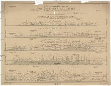
Höhen-Verhältnisse vom östlichen Hochasien
1 : 6200000 Asie východní Grimm, J. L. Scharrer, W.
Übersichts-Karte von Ost-Hoch-Asien
1 : 12760000 Asie východní Grimm, J. L. Etzel, Franz August von G. Reimer
Übersichts-Karte von Ost-Hoch-Asien
1 : 12760000 Asie východní Grimm, J. L. Etzel, Franz August von C. Ritter und O'etzel
Chinesisches Reich
Adolf Stieler's Handatlas über alle Theile der Erde und über das Weltgebäude Stieler, Adolf Justus Perthes
China - political.
1 : 10000000 John Bartholomew and Son
China. Pergamon World Atlas.
Polish Army Topography Service
Mongolia and China. Pergamon World Atlas.
1 : 10000000 Polish Army Topography Service
地理志略:大清國圖
地理志略 1903年,Alice S. Parker 此为用厦门闽南方言表述、罗马拼音书写的世界地理介绍性著作,介绍了清朝地理和世界六大洲地理概况。内有《大清國》图和《十八省》图,分别为全清和内地省级行政区划图。 2图,彩色,厦门方言罗马拼音,19.8 x 22.8 cm Harvard-Yenching | Rare Book | TA 2380 68.1,Hollis Number:008161903
天下九邊萬國人跡路程全圖
天下九邊萬國人跡路程全圖 康熙二年(1663年),姑苏王君甫 此图按内容上属于世界地图,主体部分刻绘了明朝两京十三省府、州、县及边镇卫所等。图东北方绘制了大东洋和美洲(加拿太国和古巴岛等),东南方绘制了日本国、毛人国、女人国、川心国等,该图对南方的绘制方位变形很大,福建已到图下方,该方位的海面有琉球国、三首国、三身国、金齿国等;图西南方向则有大食、槟榔、吕蒙等以及黄河源头昆仑山附近的葫芦形湖泊“星宿海”;图西北方则为大西洋、非洲和欧洲,标注了泥禄河、地中海、佛沙国等;北部则标注了鞑靼等地。这反映明清之际人们对世界的认识。全图由八块刻板拼印而成,有较明显的拼接痕迹。 图上方为题记,左侧罗列外国名称及简介,右侧罗列边疆重要卫所和关隘,下方是题为《天下京省九边外国府州县路程图》的各省文字解说,内容包括两京十三省的地理方位、历史沿革、户口数、米麦、绢丝棉麻、盐引数等统计数据,同时附有两京十三省下辖府县数及到其他省份的里程。 图上府用正方形,着红色;县用椭圆形,着黄色;州及西南土州、土府、长官司等用长方形,着深褐色;卫所用菱形,着浅褐色。大洋、河流、湖泊等水域绘有波纹。 本图为民间私刻,内容和形制上与明万历二十一年梁辀镌刻的《乾坤萬國全圖古今人物事蹟》、明崇祯十七年曹君义刻印的《天下九邊分野人跡路程全圖》、明末季名台刻印的《九州分野輿圖古今人物事跡》等图相似,应有较强的传承关系。在本图成图之后,日本帝幾書坊梅村彌白曾翻刻了王君甫的这张图,将图题和图下解说中的“天下”改为“大明”,称为《大明九邊萬國人跡路程全圖》,除此以外,内容完全一致,只是图上府、州、县、卫所等未着色而已,可以说是本图的复印件。 1图,刻本,彩色,中文,125 x 122.5 cm Harvard-Yenching | Rare Book | T 3080 4643,Hollis Number:008690193 姑蘇:王君甫
Hindostan or British India.
1 : 10000000 Colton, G.W.
China.
1 : 10000000 Colton, G.W.
China.
1 : 5500000 Thomson, John
China
1 : 9500000
Carte industrielle de la Chine, contenant les lignes ferrées & lignes télégraphiques construites, concédées & probables, les mines & usines connues ...
1 : 4625000
China.
1 : 10771200 Colton, G.W.
China and Japan.
1 : 9000000 Johnson, A.J.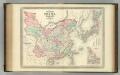
China and Japan.
1 : 9000000 Johnson, A.J.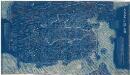
大清萬年一統地理全圖
大清萬年一統地理全圖 嘉庆十八至二十年(1814-1816年),黄千人原作 此图根据乾隆年间黄千人《大清万年一统天下全图》增补翻刻而成。黄千人制图之时,大小金川、新疆、西藏等尚未平定,河口海岸也有所偏差,此版修订反映乾隆至嘉庆年间的新变化。其空间范围西起帕米尔、东至朝鲜、南抵南海、北达黑龙江。陆地部分为蓝底白字,海水则绘制碧波纹,图幅广大,壮阔明朗,全图分为八条屏幅印制,以便于旅途携带,供“博雅君子悬壁纵观天下之广”。 黄千人(1694-1771),字证孙,浙江余姚人,乾隆三十二年(1767)将其祖父黄宗羲旧刻舆图重订为《大清万年一统天下全图》并付梓。燕京馆藏本是据1767年本的翻刻本,翻刻时间约1814至1816年间。 1图,蓝色刻本,中文,128 x 228 cm,计里画方,每方百里。 Harvard-Yenching | Rare Book | T 3080.8 4831;Hollis Number:009747467 黃千人 缺
大明九辺萬國人跡路程全圖.
大明九辺萬國人跡路程全圖 日本:帝幾書坊梅村彌白翻刻。 此图翻刻自康熙二年[1663] 王君甫的《天下九邊萬國人跡路程全圖》,内容一致,只是将图题和图下解说中的“天下”改为“大明”,并未着色而已。具体见“天下九邊萬國人跡路程全圖”条目。 1图,黑白刻本,中文,图幅122.5 x 122.8 cm,无比例尺和经纬度。 Harvard-Yenching | Rare Book | TJ 3080 4643 F,Hollis Number:008628419 帝幾書坊梅村彌白翻刻
China.
1 : 11272000 Johnson, A.J.
地理志略:十八省
地理志略 1903年,Alice S. Parker 此为用厦门闽南方言表述、罗马拼音书写的世界地理介绍性著作,介绍了清朝地理和世界六大洲地理概况。内有《大清國》图和《十八省》图,分别为全清和内地省级行政区划图。 2图,彩色,厦门方言罗马拼音,19.8 x 22.8 cm Harvard-Yenching | Rare Book | TA 2380 68.1,Hollis Number:008161904
Karte von China mit dessen Eintheilung in 18 Provinzen
1 : 6500000 Roost, J. B Verlag der liter. artist. Anstalt der L.G. Cotta'schen Buchhandlung
Imperii Sinarvm nova descriptio / auctore Joh van Loon
1 : 6200000 1 Karte : Kupferdruck ; 46 x 51 cm Loon, Jan van Johannes Janssonius]
China.
1 : 10200000 Bowen, Emanuel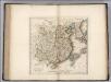
China.
1 : 10500000 Carey, Mathew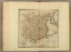
China.
1 : 10500000 Carey, Mathew
China, divided into it's Great Provinces.
1 : 12672000 Carey, Mathew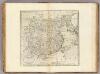
China divided into it's Great Provinces.
1 : 12672000 Carey, Mathew
China divided into it's Great Provinces.
1 : 12672000 Carey, Mathew