Maps of Pakistan

Bokhara, Cabool, Beloochistan &c
1 : 5000000 Asie střední Walker, C. Society for the diffusion of useful knowledge
Bokhara, Cabool, Beloochistan &c.
1 : 4400000 Society for the Diffusion of Useful Knowledge (Great Britain)
Tabula Asiae IX. [Karte], in: Geographia universalis vetus et nova complectens Claudii Ptolemaei Alexandrini enarrationis libros VIII, S. 290.
1 Karte aus Atlas Münster, Sebastian [und Ptolemaeus, Claudius]
Iran, Afganistan (1951)
Iran i Afganistan. Union of Soviet Socialist Republics. Glavnoe upravlenie geodezii i kartografii. Moskva : Glavnoe upravlenie geodezii i kartografii pri Sovete Ministrov SSSR
Punjab, Afghanistan
Tallis's Illustrated Atlas, and Modern History of the World, Geographical, Political, Commercial, and Statistical. Edited by R. Montgomery Martin. London : John Tallis and Co.
Cabool, The Punjab and Beloochistan.
1 : 6969600 Tallis, J. & F.
Bokhara, Cabool, Beloochistan & c
1 : 4300000 Balúčistán (Pákistán) Walker, John Walker, Alexander Society for the Diffusion of Useful Knowledge
Iran Östliche Hälfte enthaltend Afghanistan, Balutschistan und die Özbeghischen Khanate am Oxus
1 : 3000000 Afghánistán Kiepert, Heinrich Dietrich Reimer
Karte von Afghanistan und den angrenzenden Gebieten
1 : 500000 Afghánistán Petermann, August W. Nagel
Beloochistan and Sinde.
1 : 3380000 Sharpe, J.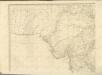

Afghanistan [Ethnographical map of] (1921)
Ethnographical map of Afghanistan, GSGS 2963. Shows racial and tribal (and linguistic) boundaries in Afghanistan and also Pathan areas of India (Pakistan). Reproduced from Indian Staff map. Great Britain. General Staff. Geographical Section. [London] : [GSGS, War Office]
Karte von Afghanistan
1 : 2100000 Afghánistán Freytag, Gustav G. Freytag
Afghanistan

Afghanistan and the Punjab.
1 : 3380000 Sharpe, J.
Church Missionary Atlas: Part of the Bombay Presidency

Versuch einer Darstellung von Süd Jran [sic]
1 : 2200000 Balúčistán (Pákistán) Zimmermann, Carl Delius, Hermann D. Reimer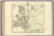
Beloutchistan. Asie 81.
1 : 1641836 Vandermaelen, Philippe, 1795-1869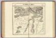
Partie du Caboul. Asie 67.
1 : 1641836 Vandermaelen, Philippe, 1795-1869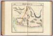
Beloutchistan. Asie 80.
1 : 1641836 Vandermaelen, Philippe, 1795-1869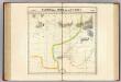
Partie, la Perse, du Caboul. Asie 66.
1 : 1641836 Vandermaelen, Philippe, 1795-1869
India 5.
1 : 2217600 Letts, Son & Co.
India V.
1 : 2200000 Society for the Diffusion of Useful Knowledge (Great Britain)
India 12.
1 : 2217600 Letts, Son & Co.
Geognostische Skizze des Erzgebirges von Uspallata.
1 : 555555 Uspallata (Argentina) Burmeister, Hermann Reimer, Dietrich Dietrich Reimer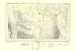
Sind Survey, Sheet No 26
India Office reference collection of maps Survey of India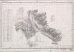
Oman, Maps MOD MDR Misc 12418
Maskat and Matrah, MDR Misc 12418. From a series of Oman, Maps MOD MDR Misc 12418. Originally published in 1906 under the direction of the Surveyor General of India using 1904-5 data. Reprinted in 1959 and overprinted in 1960. Great Britain. Army. Royal Engineers. Survey Engineers Regiment, 42nd. [Nicosia] : [Survey Directorate, Middle East]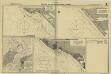
India. West Coast (1929)
[India. West Coast. Plans on the Kathiawar Coast. (Navibandar. Surveyed 1887.--Okha Port ... Surveyed ... 1922-23.--Porbander. Surveyed ... 1887)]
Plan-kroki Taš-Keprinskago boja
Turkmenistan Merw Tash-Kepri Eroberung


