Maps of Afghanistan

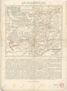
Afghanistan

Karte von Afghanistan und den angrenzenden Gebieten
1 : 500000 Afghánistán Petermann, August W. Nagel
Afghanistan [Ethnographical map of] (1921)
Ethnographical map of Afghanistan, GSGS 2963. Shows racial and tribal (and linguistic) boundaries in Afghanistan and also Pathan areas of India (Pakistan). Reproduced from Indian Staff map. Great Britain. General Staff. Geographical Section. [London] : [GSGS, War Office]
Iran Östliche Hälfte enthaltend Afghanistan, Balutschistan und die Özbeghischen Khanate am Oxus
1 : 3000000 Afghánistán Kiepert, Heinrich Dietrich Reimer
Karte von Afghanistan
1 : 2100000 Afghánistán Freytag, Gustav G. Freytag
Afghanistan and the Punjab.
1 : 3380000 Sharpe, J.
India 12.
1 : 2217600 Letts, Son & Co.
Partie du Caboul. Asie 67.
1 : 1641836 Vandermaelen, Philippe, 1795-1869
Der Sikh-Staat.
1 : 2200000 Flemming, Carl
Panjab, Afghanistan, Kashmeer, Sinde &c.
1 : 2200000 Society for the Diffusion of Useful Knowledge (Great Britain)
136. Punjab. Calcutta. Bombay. The World Atlas.
1 : 2500000 USSR (Union of Soviet Socialist Republics).
Kafiristan
1 : 257000 Afghánistán Surveyor general's office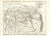
Charte von Kaschemir: Aus einer in der Nationalbibliothek zu Paris von Capt. Gentil niedergelegten Beschreibung Hindostan's
Landes-Industrie-Comptoir
Upper Swat and adjacent hill tracts
An archæological tour in Upper Swāt and adjacent hill tracts. Stein, Aurel, Sir, 1862-1943. Calcutta
Geognostische Skizze des Erzgebirges von Uspallata.
1 : 555555 Uspallata (Argentina) Burmeister, Hermann Reimer, Dietrich Dietrich Reimer
Plan-kroki Taš-Keprinskago boja
Turkmenistan Merw Tash-Kepri Eroberung
Bokhara, Cabool, Beloochistan & c
1 : 4300000 Balúčistán (Pákistán) Walker, John Walker, Alexander Society for the Diffusion of Useful Knowledge
Iran, Afganistan (1951)
Iran i Afganistan. Union of Soviet Socialist Republics. Glavnoe upravlenie geodezii i kartografii. Moskva : Glavnoe upravlenie geodezii i kartografii pri Sovete Ministrov SSSR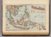
Siam, Malay Archipelago.
1 : 18000000 Andree, Richard; Times (London, England)
Afghanistan, Baluchistan.
1 : 6000000 Andree, Richard; Times (London, England)
Induslander.
1 : 4000000 Kiepert, Heinrich, 1818-1899
Inde N.-O. et Afganistan.
1 : 5000000 Vivien St Martin, L.
Sindetic Hindoostan or the countries occupied by the Sinde or Indus and its branches
1 : 7000000 Cary, John, ca. 1754-1835 J. Cary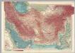
Iran, Afghanistan. Pergamon World Atlas.
1 : 5000000 Polish Army Topography Service
Persia and Afghanistan.
1 : 7200000 Hughes, William
Nona Asiae Tabula [Karte], in: Claudii Ptolemei viri Alexandrini mathematice discipline philosophi doctissimi geographie opus [...], S. 217.
1 Karte aus Atlas Waldseemüller, Martin [und Ptolemaeus, Claudius] Übelin, Georg
92. Persia, Afghanistan.
1 : 7500000 Touring club italiano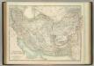
Persia and Afghanistan.
1 : 4311000 Johnston, W. & A.K.
Nord-Indien
1 : 4000000 Indie severní War Office