Maps of Praha

Belagerung der Königl. Haupt-Stadt Prag
1 : 57000 Berounka (Česko) Werner, Bedřich Bernard Strahowsky, B.
Belagerung der königlicher Haupt-Stadt Prag...

Umgebung der königl. Hauptstadt Prag
Praha-oblast (Česko) Heber, Franz Alexander Berra, Marco Marco Berra
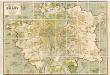
Velká Praha a okolí

Regulační plán Velké Prahy s okolím
1 : 50000
[Praha a okolí]
Praha-oblast (Česko)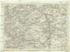
Umgebung von Prag
Praha-oblast (Česko) Biller, Bernhardt Marco Berra
Praha a okolí
Praha (Česko : oblast) Kuchař, Karel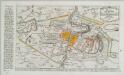
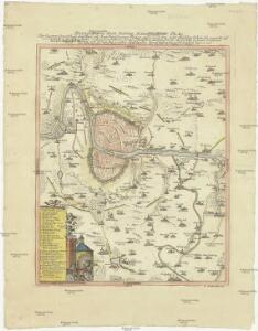
Plan der Battaille welche d. 6. Maj zwischen den Kayserl. Königl. Ungarische[n] u. Königlich Preusische[n] Armee bey Prag geliefert worden. 1757
1 : 90000
Přesná nivelace Velké Prahy s okolím : [přehled nivelačních tratí a osazených výškových bodů]
1 : 25000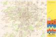
Jižní Město. - Litochleby Orientační plán 3. souboru
1 : 2500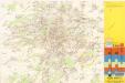
Jižní Město. - Háje Orientační plán 1. souboru
1 : 3500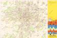
Jižní Město. - Opatov Orientační plán 2. souboru
1 : 2500
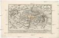
[Umgebungen der königl. Hauptstadt Prag]
1 : 45000 Praha-oblast (Česko) Basdar
Plan van de stadt en de beleegering van Praag, 1757 = Plan de la ville & du siege de Prague, en 1757
T. Otten sc. ['s-Gravenhage] : P. Gosse excudit
Praha - městská hromadná doprava
1 : 40000
Mapa bývalého dekanátu [sic] Ořechovského
Ořech (Česko) Schmidt, Eduard Winkler, Johann Christoph
Přehledná mapa Velké Prahy
1 : 35000 Praha (Česko : oblast) Brož, Josef A. Storch syn
Soubor map okresů Pražského kraje
Plan der Battaille welche d. 6. Maj zwischen der kayserlich-königlich-ungarischen und königlich preussischen Armée bey Prag geliefert worden, 1757
Praha (Česko)
Městské podniky Pražské

Bez titulu: Čechy – kolekce vedut

Nový, úředně schválený plán Velké Prahy
1 : 25000
Mapa okresu smíchovského v Pražském kraji = Karte des Smichower Bezirkes im Prager Kreise : podle nejnovějších a nejbezpečnějších pramenů sestavena a vydána k založení obecních knihoven ve veškerých okresích kraje Pražského

Výškopisný plán hlavního města Prahy s okolím
1 : 20000 Praha (Česko) obec Pražská
Verbesserter Grundriß der königl. bohmischen Haupt Stadt Prag mit der königl. ungarschen Belagerung und Attaquen A 1742
Praha (Česko) Riegel, Christoph bey Christoph Riegel
Grundriß der königl. bohmischen Haupt Stadt Prag mit der königl ungarschen Belagerung und Attaquen A 1742
Praha (Česko)
Orientační plán hlavního města Prahy s okolím

Uliční mapa hlavního města Prahy