Maps of Dejvice
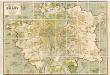
Orientační plán hlavního města Prahy
1 : 14000
Plan van de stadt en de beleegering van Praag, 1757 = Plan de la ville & du siege de Prague, en 1757
T. Otten sc. ['s-Gravenhage] : P. Gosse excudit
Městské podniky Pražské

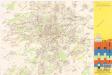
Orientační plán hlavního města Prahy s okolím

Plán velké Prahy
1 : 19000 Praha (Česko) Grgurič, Václav Sádlo, Jiří A. Storch syn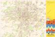
Jižní Město. - Opatov Orientační plán 2. souboru
1 : 2500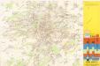
Jižní Město. - Háje Orientační plán 1. souboru
1 : 3500
Uliční mapa hlavního města Prahy

Hlavní město Praha
1 : 55000 Praha (Česko)
Plán Velké Prahy
1 : 19000
Nový, úředně schválený plán Velké Prahy
1 : 25000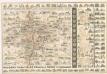
Praha : názorné plány a rejstřík
Jižní Město. - Litochleby Orientační plán 3. souboru
1 : 2500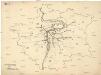
[Praha - projekt podzemní a nadzemní dráhy].
Praha (Česko) Poláček, K. Wallenfels, F.
[Praha - projekt podzemní dráhy]
Praha (Česko)
Auto-Praha : automobilní plán Velké Prahy a příručka pro automobilisty
1 : 50000
Přehledná mapa Velké Prahy
1 : 35000 Praha (Česko : oblast) Brož, Josef A. Storch syn
Blocus de Prague
1 : 106600 Praha (Česko) Therbu Coentgen, Heinrich Hugo
Zu Bildner des Heeres Beilage 9
1 : 63000 Praha-oblast (Česko) K.k. Schulbücher-Verschleiss-Administration
Specielle Telegrafen und Eisenbahn Karte von Böhmen

Výškopisný plán hlavního města Prahy s okolím
1 : 20000 Praha (Česko) obec Pražská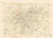
Plán sběrného okruhu a dopravních spojů pro motorová vozidla
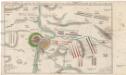
Accurate Vorstellung der zwischen den oesterreichischen und preussischen Armeen geschehenen Bataille bey Prag, den 6. May 1757
Praha (Česko)
Přehledná mapa Velké Prahy : [s průvodcem a popisem všech obcí v ní zahrnutých] : [odpolední výlety po okolí pražském]
1 : 34725
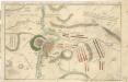
Belagerung der königlicher Haupt-Stadt Prag...

[Praha a okolí]
Praha-oblast (Česko)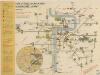
Plán sítě elektrických drah hlavního města Prahy

Přehledná mapa velké Prahy
Accurate Vorstellung der zwischen den Oesterreichischen und Preussischen Armeen ... Bataille bey Prag...


