Maps of Berehove Raion

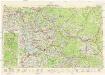
Berehovo a okolí
1 : 75000 Vojenský zeměpisný ústav
III. vojenské mapování 4769
1 : 75000
Beregszász und Mezö-Tarpa
1 : 75000 Maďarsko Jonak K. u. k. Militärgeographisches Institut
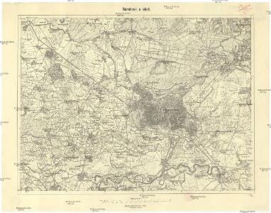
Beregszász und Mező-Tarpa
1 : 75000 Transkarpatien, Berehove Geripp: Feldw. König. Terrain: Hauptm. v. Jonak u. Hauptm. Trica
Beregszasz und Mezo-Tarpa.
from Spezialkarte der osterreichisch-ungarischen Monarchie.
Munkacs.
from Spezialkarte der osterreichisch-ungarischen Monarchie.
Berehovo a Mezötarpa
1 : 75000 Maďarsko Vojenský zeměpisný ústav
Munkács
1 : 75000 Mukatschewe, Umland Geripp: Leut. Kimlein. Terrain: Oberlt. Boltek
III. vojenské mapování 4669
1 : 75000
Bereg és Ugocsa vármegye térképe
1 : 300000 Kogutowicz, Manó Magyar Földrajzi Intézet

C. Bereghiensis
Ungarn Ukraine Komitat Bereg

Comitat Beregh-Ugocsa
1 : 288000 Mukačevo (Ukrajina)
Comitat Beregh-Ugocsa
1 : 290000 Berehove (Ukrajina : oblast)
Gorgany Zachodnie
1 : 100000 Lenkiewicz, Adam Książnica-Atlas
Generální mapa ČSR

Mukačevo
1 : 75000 Ukrajina Vojenský zeměpisný ústav

C. Ugocsiensis
Rumänien Ukraine Komitat Ugocsa
Nacy-Szollos und Huszt.
from Spezialkarte der osterreichisch-ungarischen Monarchie.
Munkács
1 : 75000 Ukrajina Boltek K. u. k. Militärgeographisches Institut
Bilke.
from Spezialkarte der osterreichisch-ungarischen Monarchie.
Chust
1 : 75000 Ukrajina Vojenský zeměpisný ústav
Nacy-Szőllős und Huszt
1 : 75000 Transkarpatien, Khust Geripp: Feldw. Watterich. Terrain: J. Fitz
III. vojenské mapování 4770
1 : 75000
Stolice Zemplín a Užhorod
Komitat Zemplín, Komitat Uschgorod, ethnische Gruppe
Stolice Zemplín a Užhorod
Užhorod (Ukrajina)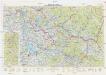
Neubertova generální automapa Republiky československé
1 : 200000 Chust (Ukrajina) Soukup, Jan V. Neubert a synové