Maps of Northern European Plain

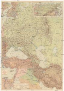
Osteuropa, Kleinasien. Arabien
1 : 5000000 Asie severní Kremling, Ernst JRO
Skandinavien und Rußland
1 : 18000000 Skandinavien, Osteuropa
Rußland
1 : 18000000 Russland / Europäischer Teil
Kompas omniumkaart bevattende: Noorwegen, Zweden, Finland, Europeesch Rusland, Europ. en Aziatisch Turkije, Irak, Middell. Zeegebied, en Suez
1 : 5500000 Den Haag : Kompas
Rußland
1 : 18000000 Russland / Europäischer Teil
Europäisches Russland
1 : 14500000 Russland / Europäischer Teil
Europäisches Russland
Russland / Europäischer Teil
Europaeisches Russland
E. von Sydow's Schul-Atlas in sechs und dreissig Karten Sydow, Emil von bei Justus Perthes
Wirtschaftskarten I. Rußland
1 : 18000000 Russland / Europäischer Teil Wirtschaft
Skandinavien und Rußland
1 : 18000000 Skandinavien, Osteuropa
Europäisches Russland
1 : 13300000 Russland / Europäischer Teil
Carta politica della Russia / Francesco Vallardi
1 : 3300000 Francesco Vallardi
Europaeisches Russland
Grosser Hand-Atlas über alle Theile der Erde in 170 Karten Meyer, J. Verlag des Bibliographischen Instituts
Praktische Geschäfts und Reisekarte sämmtlicher Staaten von Europa enthaltend die vorzüglichsten Strassen-Verbindungen mit Angage der Distanzen und der bestehenden Eisenbahnen: Nebst einem Theile von Africa u. Asien, und zwar die Länder: Marocco, Algerien u. Tunis, ganz Kleinasien, und ein Theil von Persien
Schulz, R. A.
Russland
Volksschul-Atlas über alle Teile der Erde Lange, Henry Druck und Verlag von Georg Westermann
Russiae, Moscoviae Et Tartariae Descriptio. [Karte], in: Theatrum orbis terrarum, S. 387.
1 Karte aus Atlas Ortelius, Abraham Vrients, Jan Baptista
Karte der Vergrösserungen Russlands unter Peter dem Grossen und seinen Nachfolgern
Russland Peter I.
Karte der Bevölkerung Russlands im 19. Jahrhundert
Russland Bevölkerungsdichte
Europaeisches Russland
Plastischer Schul-Atlas über alle Theile der Erde : in 24 Karten Woldermann, G Verlag von P. Eckerlein
Roman Empire at the Time of Christ.
1 : 12300000 Johnson, A.J.
Roman Empire at the Time of Christ.
1 : 12300000 Johnson, A.J.
Ost Europa
1 : 12500000 Russland / Europäischer Teil
Tabula Russiae [...] [Karte] Moscua ad Architypum Foedori Borißowitsi [Planvedute, Karte], in: Le théâtre du monde, ou, Nouvel atlas contenant les chartes et descriptions de tous les païs de la terre, Bd. 1, S. 67.
1 Karte aus Atlas Blaeu, Willem Janszoon und Blaeu, Joan Blaeu, Willem Janszoon
Europaeisches Russland mit Kasan, Astrachan und Georgien
Russland / Europäischer Teil
Karte der Vergrösserungen Russlands unter Peter dem Grossen und seinen Nachfolgern
Russland Peter I.
Russland 1682-1762
1 : 18000000 Russland Expansion
Russland
1 : 15225000 Russland / Europäischer Teil
Ruszland
1 : 18000000 Russland / Europäischer Teil
Karte der Bevölkerung Russlands im 9. Jahrhundert
Russland Bevölkerungsdichte