Maps of Belarus

Ostsee-Laender und inneres Russland bis Moskau
1 : 3700000 Moskva-oblast (Rusko) Stülpnagel, Friedrich von Ausfeld, Johann Carl Justus Perthes
Ostsee-Laender und inneres Russland bis Moskau
1 : 3700000 Moskva-oblast (Rusko) Stülpnagel, Friedrich von Ausfeld, Johann Carl Justus Perthes
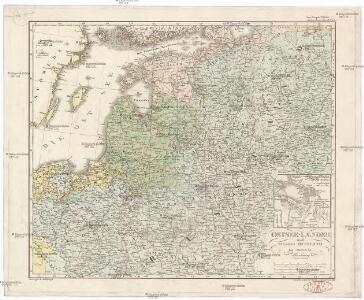
Ostsee-Laender und Inneres Russland bis Moskau
Hand-Atlas über alle Theile der Erde nach dem neuesten Zustande und über das Weltgebäude Stieler, Adolf bei Justus Perthes
Ostsee-Laender und Inneres Russland bis Moskau
Hand-Atlas über alle Theile der Erde nach dem neuesten Zustande und über das Weltgebäude Stieler, Adolf bei Justus Perthes
Ostdeutschland - Westrußland - Nordösterreich
1 : 1500000 Evropa východní Mittelbachs Verlag

Homannův atlas světa
1 : 400000
Neberts Kriegs - Frontenkarte von allen Kriegsschauplätzen No 2


Regni Poloniae Magnique Ducatus Lithuaniae Nova et exacta Tabula ad mentem Starovolcii descripta à Ioh. Bapt. Homanno Sac. Caes. Mai. Geographo
Polen, Litauen Homann, Johann Baptist
Regni Poloniae Magnique Ducat[us] Lithuaniae Nova et exacta Tabula
1 : 3000000 Homann, Johann Baptist
Regni Poloniae Magniquae Ducatus Lithuaniae Nova et exacta tabula
1 : 3000000 Litva Homann, Johann Baptist Starowolski, Szymon a Ioh. Bapt. Homanno
Regni Poloniae et ducatus Lithvaniae Voliniae, Podoliae Vcraniae Prvssiae, Livoniae et Cvrlandiae / descriptio emendata per F. de Wit Amstelodami
1 : 3000000 Annotatie: Rechtsboven: 14; Origineel is Blad 132 in atlas factice; Annotatie geografische gegevens: Met schaalstok: 15 Duytsche Mylen Frederick de Wit 1630-1706 [Amsterdam : F. de Wit]
Polen und Litthauen nach der Lubliner Union 1569 und dem Aussterben der Jagiellonen 1572
1 : 12000000 Polen-Litauen
Volker und Reiche der Slaven zwischen Elbe und Don bis 1125.
1 : 5000000 Spruner von Merz, Karl
Regni Poloniae et Ducatus Lithuaniae Voliniae, Podoliae Ucraniae Prussiae, Livoniae et Curlandiae descriptio [Karte], in: Novus atlas absolutissimus, Bd. 1, S. 93.
1 Karte aus Atlas Janssonius Offizin
[Osteuropa]
Evropa východní
G. Freytags Karte der westrussischen Kriegsschauplätze
1 : 2000000 Evropa východní Freytag, Gustav G. Freytag & Berndt
Reipublicae et status generalis Poloniae nova tabula, comprehendens Majoris et Minoris Poloniae Regni, Magni Ducatus Lithuaniae, Ducatus Prussiae, Curlandiae, Russiae Ucraniae, Massoviae, Volhyniae et Podoliae, accuratam descriptionem
Polen, Großfürstentum Litauen de Wit, Frederik, http://d-nb.info/gnd/11931648X
Übersichtskarte des Östlichen Kriegsschauplatzes
1 : 6000000 Osteuropa Weltkrieg <1914-1918> Verl. Gerhard Stalling, Oldenburg

Paasche's Frontenkarte, Nr.4. Der Krieg gegen Russland

Paasche's Frontenkarte, Nr.4. Der Krieg gegen Russland

Nyugat – Oroszország

Dietrich Reimer's Kriegsstandskarten. 1. 1500000, Der Kreig gegen Russland und der Kampf um die Dardanellen
1 : 1500000 Wo Stehen Unsere Armeen in Russland? 6 Ausg.,abgeschlossen am 27. Sept.1915 Dietrich Reimer Verlag Berlin : Dietrich Reimer Ernst Vohsen
Deutsch-österreichisch-russische Grenzlande
1 : 2000000 Evropa východní Velhagen & Klasing
Polen nach dem Frieden von Oliva 1660
Polen Oliva / Friede
Prusse, Lithuanie.
1 : 3200000 Clouet, J. B. L. (Jean-Baptiste Louis), b. 1730