Maps of Belarus
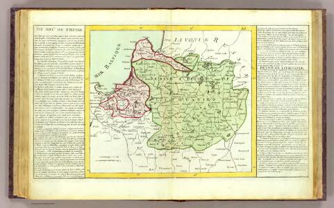
Prusse, Lithuanie.
1 : 3200000 Clouet, J. B. L. (Jean-Baptiste Louis), b. 1730
Pohlen und Lithauen
1 : 2775000 Bělorusko Engelman, J. W.
Poland.
1 : 3600000 Carey, Mathew
Poland.
1 : 3700000 Carey, Mathew
Poland, Shewing the Claims of Russia, Prussia & Austria.
1 : 3801600 Carey, Mathew
Poland, Shewing the Claims of Russia, Prussia & Austria.
1 : 3864960 Carey, Mathew
Poland, Shewing the Claims of Russia, Prussia & Austria.
1 : 3864960 Carey, Mathew
Ostsee-Laender und inneres Russland bis Moskau
1 : 3700000 Moskva-oblast (Rusko) Stülpnagel, Friedrich von Ausfeld, Johann Carl Justus Perthes
Ostsee-Laender und inneres Russland bis Moskau
1 : 3700000 Moskva-oblast (Rusko) Stülpnagel, Friedrich von Ausfeld, Johann Carl Justus Perthes
Karte der Nationalitätengebiete auf dem Territorium des Grossfürstentums Litauen
Litauen Großfürstentum Litauen ethnische Gruppe Świechowski, Marian von
Regni Poloniae et ducatus Lithuaniae Voliniae, Podoliae Ucraniae Prussiae et Curlandiae descriptio
1 : 2600000 1 Karte : Kupferdruck ; 49 x 57 cm Danckerts, Cornelis [Danckerts]
Magni Ducatus Lithuaniae, Caeterarumque Regionum Illi Adiacentium Exacta Descriptio [Karte], in: Le théâtre du monde, ou, Nouvel atlas contenant les chartes et descriptions de tous les païs de la terre, Bd. 1, S. 82.
1 Karte aus Atlas Blaeu, Willem Janszoon und Blaeu, Joan Blaeu, Willem Janszoon

Magni Ducatus Lithuaniae, Caeterarumque Regionum Illi Adiacentium Exacta Descriptio [...] [Karte], in: Novus Atlas, das ist, Weltbeschreibung, Bd. 1, S. 68.
1 Karte aus Atlas Blaeu, Joan Blaeu, Willem Janszoon
Poland, Lithuania &c.
1 : 3050000 Bowen, Emanuel
Estats de la couronne de Pologne : presenté a monseigneur le duc de Bourgogne
1 : 1350000 par son [...] serviteur H. Jaillot A Amsterdam : che[z] Reinier & [Josua] Ottens
Ostsee-Laender und Inneres Russland bis Moskau
Hand-Atlas über alle Theile der Erde nach dem neuesten Zustande und über das Weltgebäude Stieler, Adolf bei Justus Perthes
Mappa geographica ex novissimis observationibus repraesentans Regnum Poloniae et magnum ducatum Lithuaniae
1 : 2800000 Evropa východní Lotter, Tobias Conrad sumptibus Tobiae Conradi Lotter
Mappa geographica Regnum Poloniae ex novissimis observationibus repraesentans Regnum Poloniae et Magnum ducatum Lithuniae
1 : 2700000 Evropa východní Lotter, Tobias Conrad T. C. Lotter
Mappa geographica Regnum Poloniae ex novissimis observationibus repraesentans Regnum Poloniae et Magnum ducatum Lithuniae
1 : 2800000 Evropa východní Lotter, Tobias Conrad T. C. Lotter
Mappa geographica Regnum Poloniae ex novissimis observationibus repraesentans Regnum Poloniae et Magnum ducatum Lithuniae
1 : 2800000 Evropa východní Lotter, Tobias Conrad T. C. Lotter
Estats de la couronne de Pologne
1 : 2600000 Evropa východní Sanson, Guillaume Cordier, Louis chez H. Jaillot
Mappa geographica ex novissimis observationibus repraesentans regnum Poloniae et magnum ducatum Lithuaniae
1 : 2740000 Litva Probst, Johann Michael Ioh. Michael Probst
Karte von Polen
1 : 1900000 Bělorusko Amon, Anton von Franz Ioh. Ios. von Reilly
Mappa geographica Poloniae, in partes suas majores Austriac. Russic. et Borrusic
1 : 2920000 Polsko per Hommanianos Heredes
Das alte und neue Polen
1 : 2690000 Polsko Michaelis, E. H. Edler. A. in Commission des geographischen dépots
Polens Umwandelungen von 1772-1809
1 : 2100000 Bělorusko in der Dykischen Buchhandlung
Magni Ducatus Lithuaniae, caeterarumque Regionum Illi Adiacentium Exacta Descriptio [Karte], in: Theatrum orbis terrarum, sive, Atlas novus, Bd. 1, S. 84.
1 Karte aus Atlas Blaeu, Joan Blaeu, Willem Janszoon
(La Pologne)
1 : 13000000 Bruyset, Jean-Marie; Schneider, J. H.