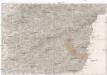
Maps of okres Uherské Hradiště

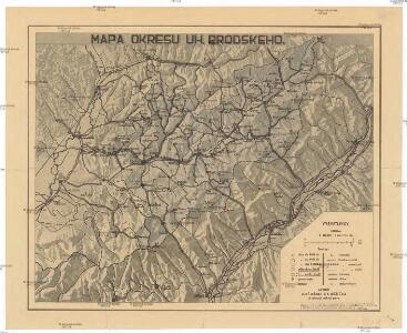
Mapa okresu uh. brodského
1 : 150000 Uherský Brod-oblast (Česko) Křivánek, K. Růžička, V.
Der Hradischer Kreis
1 : 200000 Uherské Hradiště-oblast (Česko) Schenkl, Conrad Philipp Winiker, Karel Carl Winiker
Der Hradischer Kreis
1 : 190000 Uherské Hradiště-oblast (Česko) Schenkl, Conrad Philipp Winiker, Karel Carl Winiker
Der Hradischer Kreis
1 : 190000 Uherské Hradiště-oblast (Česko) Schenkl, Conrad Philipp Winiker, Karel Carl Winiker
II. vojenské mapování 19
1 : 144000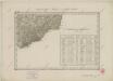
II. vojenské mapování 19
1 : 144000
Podrobná mapa Markrabství moravského a Vévodství slezského
1 : 100000 Moravské markrabství Srp, Jan Jos. R. Vilímek
Podrobná místopisná mapa Království Českého
Komunikační mapa země Moravskoslezské
1 : 100000 Trenčín (Slovensko : oblast) Morslez. zem. výbor
III. vojenské mapování 4460
1 : 75000
III. vojenské mapování 4460
1 : 75000
Unc. Hradisch und Unc. Brod.
from Spezialkarte der osterreichisch-ungarischen Monarchie.
Trentschin
1 : 75000 Trenčín, Umland Geripp: Objgr. A. Spaczek. Terrain: Hptm. Paul Smeu
Trentschin.; Spezialkarte der osterreichisch-ungarischen Monarchie.
from Spezialkarte der osterreichisch-ungarischen Monarchie. Austro-Hungarian Monarchy. Militärgeographisches Institut.,
III. vojenské mapování 4360
1 : 75000
Karte des Gemeindegrenzen

Vizovice
1 : 75000 Morava (Česko) Vojenský zeměpisný ústav
Vizovice
1 : 75000 Morava (Česko) Vojenský zeměpisný ústav
Vizovice a Beluša
1 : 75000 Morava (Česko) Vojenský zeměpisný ústav
Beluša a Vizovice
1 : 75000 Morava (Česko) Vojenský zeměpisný ústav
Beluša a Vizovice
1 : 75000 Morava (Česko) Vojenský zeměpisný ústav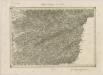
II. vojenské mapování 15
1 : 144000
Nové Mesto n. Váhom
1 : 75000 Nové Mesto nad Váhom-oblast (Slovensko) Vojenský zeměpisný ústav
Nové Mesto n. Váhom a Uherský Ostroh
1 : 75000 Morava (Česko) Vojenský zeměpisný ústav
Nové Mesto n. Váhom a Uherský Ostroh
1 : 75000 Morava (Česko) Vojenský zeměpisný ústav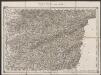
Umgebungen von Zlin
1 : 144000 K.K. Militärisches Geographisches Institut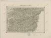
II. vojenské mapování 15
1 : 144000
II. vojenské mapování 15
1 : 144000
Ungostra und Waag-Neustadtl.
from Spezialkarte der osterreichisch-ungarischen Monarchie.