Maps of okres Uherské Hradiště

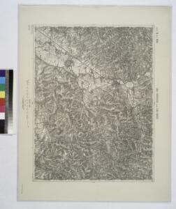
Unc. Hradisch und Unc. Brod.
from Spezialkarte der osterreichisch-ungarischen Monarchie.
Zlin
1 : 75000 Morava (Česko) Vojenský zeměpisný ústav
Uherské Hradiště
1 : 75000 Morava (Česko) Vojenský zeměpisný ústav
III. vojenské mapování 4359
1 : 75000
Podrobné mapy zemí Koruny české v měřítku 1:75.000 a mapa vzdáleností všech míst při silnici ležících
1 : 75000 Luhačovice-oblast (Česko) Bělohlav, Josef Kučera, Karel F. Topič

Podrobná místopisná mapa Království Českého

Podrobná mapa Markrabství moravského a Vévodství slezského
1 : 100000 Holešov (Česko : oblast) Srp, Jan Jos. R. Vilímek

[Gradkartenblatt]
1 : 25000 Morava (Česko) Vojenský zeměpisný ústav
[Gradkartenblatt]
1 : 25000 Morava (Česko) Vojenský zeměpisný ústav
III. vojenské mapování 4359/4
1 : 25000

[Gradkartenblatt]
1 : 25000 Luhačovice-oblast (Česko) Vojenský zeměpisný ústav

[Gradkartenblatt]
1 : 25000 Morava (Česko) Vojenský zeměpisný ústav
Gradkartenblatt
1 : 25000 Morava (Česko) Bellmond, Conrad
III. vojenské mapování 4359/1
1 : 25000
Gradkartenblatt
1 : 25000 Luhačovice-oblast (Česko) Bellmond, Conrad
Gradkartenblatt
1 : 25000 Morava (Česko) Bellmond, Conrad
Gradkartenblatt
1 : 25000 Morava (Česko) Catinelli, Max von
III. vojenské mapování 4359/2
1 : 25000
III. vojenské mapování 4359/3
1 : 25000
Orientační mapy. Luhačovice

Orientační mapy. Luhačovice


Umgebungen Banow und die Höhen Tabelle
1 : 144000 K.K. Militärisches Geographisches Institut