Maps of Baltic Plains

[Evropa]
Evropa
G. Freytags Übersichtskarte des deutsch-russischen Kriegsschauplatzes
1 : 2000000 Německo Kartogr. Anstalt G. Freytag & Berndt
Ostsee-Laender von der Oder bis zur Newa
Stieler's Hand-Atlas Stieler, Adolf bei Justus Perthes
Ost-Europa, No. 3: Sud-Schweden, die Russischen Ostsee-Provinzen, Polen & West-Russland.
1 : 3700000 Petermann, A.
[Ost-Europa in 6 Blättern, Enthaltend: Norwegen, Schweden, Russland, Kaukasien und die Türkei, Blatt 3]
Hand-Atlas über alle Theile der Erde und über das Weltgebäude Stieler, Adolf Justus Perthes
[Kaart], uit: G. Freytags Übersichtskarte des Deutsch-Russischen Kriegsschauplatzes
1 : 2000000 titelvariant: Übersichtskarte des Deutsch-Russischen Kriegsschauplatzes; Annotatie: Omslagtitel: Übersichtskarte des Deutsch-Russischen Kriegsschauplatzes Freytag, G. Wien : Freytag & Berndt
Ostmitteleuropa 1989
Ostmitteleuropa Kunz, Andreas ; Treiling, Thomas
Carte von Polen und einen grossen Theil der angrenzenden Laender
1 : 1300000 Evropa střední a východní Rendziny, Stanislaus Gilly Tranquillo Mollo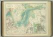
Basin of the Baltic.
1 : 2400000 Johnston, W. & A.K.
Regnum Poloniae eiusque confinia
1 : 11100000 1 Karte : Kupferdruck ; 13 x 17 cm Weigel, Johann Christoph [Johann Christoph Weigel]
Reise Charte durch das Königreich Polen mit allen darzu gehörigen Laendern / verfertiget von JG. S
1 : 9300000 1 Karte : Kupferdruck ; 16 x 21 cm, Bildgr. 17 x 25 cm Schreiber, Johann Georg [J. G. Schreiber]
Ostmitteleuropa 1949
Ostmitteleuropa Kunz, Andreas ; Treiling, Thomas
Ostmitteleuropa 1991
Ostmitteleuropa Kunz, Andreas ; Treiling, Thomas
Ostmitteleuropa 2003
Ostmitteleuropa Kunz, Andreas ; Treiling, Thomas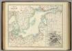
Basin of the Baltic.
1 : 2400000 Johnston, Alexander Keith
Mare Balticum
1 Karte : Kupferdruck ; 49 x 57 cm Renard gedruckt by L. Renard
Ostmitteleuropa 1815
Ostmitteleuropa Kunz, Andreas ; Johnen, Bettina ; Moeschl, Joachim Robert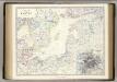
Baltic.
1 : 4400000 Johnston, Alexander Keith, 1804-1871
K vojně so Švecīej 1808 - 1809 gg.
Schweden Seeschlacht Russisch-Schwedischer Krieg <1808-1809>
Ostdeutschland - Westrußland - Nordösterreich
1 : 1500000 Evropa východní Mittelbachs Verlag
Deutsch-österreichisch-russische Grenzlande
1 : 2000000 Evropa východní Velhagen & Klasing
Deutsch-russische Grenzlande
1 : 2000000 Evropa východní Velhagen & Klasing
Ostmitteleuropa 1830
Ostmitteleuropa Kunz, Andreas ; Röss, Wolf ; Johnen, Bettina ; Moeschl, Joachim Robert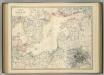
Basin of the Baltic.
1 : 2400000 Johnston, Alexander Keith
Ostmitteleuropa 1937
Ostmitteleuropa Kunz, Andreas ; Treiling, Thomas
Ostmitteleuropa 1809
Ostmitteleuropa Kunz, Andreas ; Treiling, Thomas
Ostmitteleuropa 1923
Ostmitteleuropa Kunz, Andreas ; Treiling, Thomas
Ostmitteleuropa 1914
Ostmitteleuropa Kunz, Andreas ; Röss, Wolf ; Johnen, Bettina ; Moeschl, Joachim Robert
![[Evropa]](https://images-2.georeferencer.com/images/iiif/809811676095/full/,300/0/native.jpg)

