Maps of Diyarbakir

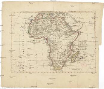
Charte von Africa
Afrika Kiepert, Heinrich Voss, L.
Rekognoscirovka Geok-Tepe 4-go dekabrja 1880 goda
Turkmenistan Gökdepe Eroberung
Vylazka 30 dekabrja 1880 goda
Turkmenistan Gökdepe Eroberung
Vylazka 28 dekabrja 1880 goda
Turkmenistan Gökdepe Eroberung
Šturm kr. Dengil'-Tepe 12-go janvarja 1881 g.
Turkmenistan Eroberung
Plan osadnych rabot iz tret'ej paralleli
Turkmenistan Gökdepe Eroberung
Geognostische Karte des Taurus und seinen Nebenzweige in den Paschaliken Adana und Marasch, nebst dem angrenzenden Theile des Paschalikes von Aleppo
1 : 600000 Taurus, pohoří (Turecko) Russegger, Joseph E. Schweizerbart'schen Buchhandlung
Karte des Taurus und seinen Nebenzweige in den Paschaliken Adana und Marasch, nebst dem angrenzenden Theile des Paschalikes von Aleppo
1 : 600000 Taurus, pohoří (Turecko) Russegger, Joseph E. Schweizerbart'schen Buchhandlung
Karte des Taurus und seiner Nebenzweige in den Paschaliken Adana und Marasch, nebst dem angrenzenden Theile des Paschalikes von Aleppo
1 : 600000 Taurus, pohoří (Turecko) Russegger, Joseph im k. k. Militärisch-geographischen Institute
Chs. Texiers Route im östlichen Kleinasien 1836
Malá Asie Kiepert, Heinrich D. Reimer
Karte der Gegend zwischen Bofanti und Tarsus
1 : 100000 Tarsus (Turecko) Kartographische Abteilung des Stellvertr. Generalstab der Armee
Tabula Asiae III. [Karte], in: Claud. Ptolemaeus. Geographia lat. cum mappis [...], S. 302.
1 Karte aus Atlas Münster, Sebastian [und Ptolemaeus, Claudius]
Tabula Asiae III. [Karte], in: Geographia universalis vetus et nova complectens Claudii Ptolemaei Alexandrini enarrationis libros VIII, S. 272.
1 Karte aus Atlas Münster, Sebastian [und Ptolemaeus, Claudius]
Nova ac verissima Maris Caspii ante hac maximam fere partem nobis incognita ac regionum adjacentium delineatio : jussu invictissimi principis Petri Alexii fil. magni Russorum imperatoris
1 : 1500000 immenso labore et maximis sumptibus facta, atque ex autographo in lucem edita per Reinerum Ottens geographum Amstelaedam. Iacob Keyser sculp. Gedrukt t'Amsterdam : by de Wed. I. Ottens op de Nieuwen Dyk in de Wereldkaart
Tiefländer
Atlas der Geologie Zittel, K.v. ; Berghaus, Hermann Justus Perthes
Mer Caspiene, Pays voisins.
1 : 3150000 L'Isle, Guillaume de, 1675-1726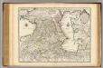
Mer Caspiene, Pays voisins.
1 : 3150000 L'Isle, Guillaume de, 1675-1726
Assyrie, Babylonie a Persie
Carte des pays voisins de la Mer Caspiene / dressée pour l'usage du roy sur la carte de cette mer f
1 : 3100000 1 Karte : Kupferdruck ; 44 x 59 cm L'Isle, Guillaume de chez Jean Cóvens et Corneille Mortier geographes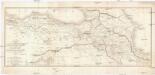
CARTE DES PAYS COMPRIS ENTRE CONSTANTINOPLE ET TÉHÉRAN
1 : 2230000 Arménie Lapie, Pierre Flahaut
Tercia Asiae Tabula [Karte], in: Claudii Ptolemei viri Alexandrini mathematice discipline philosophi doctissimi geographie opus [...], S. 199.
1 Karte aus Atlas Waldseemüller, Martin [und Ptolemaeus, Claudius] Übelin, Georg
Quarta Asiae Tabula [Karte], in: Claudii Ptolemei viri Alexandrini mathematice discipline philosophi doctissimi geographie opus [...], S. 202.
1 Karte aus Atlas Waldseemüller, Martin [und Ptolemaeus, Claudius] Übelin, Georg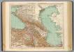
73-74. Caucasia, Mar Caspio.
1 : 3000000 Touring club italiano
Charte der Laender am Caucasus nach den besten vorhandenen
1 : 2100000 Reinecke, J. C. M. (Johann Christoph Matthias), 1770-1818 Im Verlage des Industrie Comptoirs
Neueste Specialkarte von Persien
Grosser Hand-Atlas über alle Theile der Erde in 170 Karten Meyer, J. Verlag des Bibliographischen Instituts
L'Euphrate et le Tigre
1 : 2400000 Anville, Jean Baptiste Bourguignon d', 1697-1782 [s.n.]
Persien.
1 : 4430000 Grassl, J. (Joseph)
Africa.
1 : 18250000 Chapin, Amanda
[Blízký východ-starověk]
starověký Egypt Kiepert, Heinrich Arnd