Maps of Tigray

Jobi Ludolfi Habessinia seu Abassia, presbyteri Johannis regio
Etiopie Ludolf, Christian Habess, Gregorius
Sennaar. Afrique 25.
1 : 1641836 Vandermaelen, Philippe, 1795-1869
Carta dimostrattiva della regione compresa fra Massaua, Keren, Aksum e Adigrat
1 : 400000 Eritrea
I confini tra l'Abissinia e i possedimenti italiani
1 : 400000 Eritrea Antonio Vallardi
Carta speciale della regione attorno a Massaua
1 : 200000 Eritrea Cora, Guido
Carta della Colonia Eritrea. Buia
1 : 100000 Istituto geografico militare. Italie [Florence] : Istituto geografico militare
Schizzo topografico di Massaua e dintorni
Eritrea Antonio Vallardi
Asmara [Town plan] (1938)
Asmara [Town plan], MOD Misc 190. Great Britain. Directorate of Military Survey. [Cairo] : [Middle East Command]
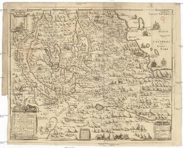
Habessinia seu Abassia, presbyteri Johannis regio perperam dicta ... / Jobi Lodolfi [cart.] ; Christianus Ludolfus J. Filius delineavit ex autographo Parentis
1 : 2400000 Annotatie: Origineel is Blad 211 in atlas factice Jobus Ludolphus 1624-1704; Christianus Ludolfus [Amsterdam] : [s.n.]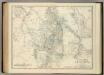
Upper Nubia and Abyssinia.
1 : 2854868 Johnston, Alexander Keith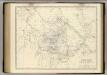
Nubia, Abyssinia.
1 : 2854868 Johnston, Alexander Keith, 1804-1871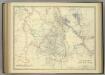
Upper Nubia and Abyssinia.
1 : 2854868 Johnston, Alexander Keith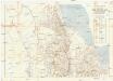
Seconda edizione della nuova carta dei domini e protettorati italiani nell' Eritrea e regioni limitrofe
1 : 1500000 Eritrea Ministero della guerra
Carta della colonia Eritrea coll'Abissinia : e regioni limitrofe tra il Nilo, Suakin e il Golfo d'Aden
1 : 4000000 Cora, Guido, 1851-1917 Fratelli Bocca
Karte von Aethiopien (H'abeš, Takah & Ost-Senar)
1 : 2500000 Eritrea Heuglin, Theodor von Bruce Hermann Costenoble
Nubia and Abyssinia to Bab El Mandeb.
1 : 3380000 Sharpe, J.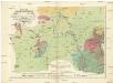
Geognostiche Karte von ost Sudan, umfaßsend dei Länder Kordofan, Nuba, Sennaar, Roserres, Faßsokl und el Pert nebst den angrenzenden Theilen von Dar Fur, Nubien, Ab eßsinien und den Galla Ländern
1 : 1800000 Etiopie E. Schweizerbart'schen Buchhandlung
Carte d'Abyssinie et des contrées adjacentes dressée partie d'après des observations faites sur les lieux par l'auteur, partie d'après les informations prises dans le pays en 1809 et 1810
1 : 5000000 par Henry Salt [S.l.] : [s.n.]
Carte générale d'Abyssinie
1 : 1800000 dressée par M. le lieutenant de vaisseau Théophile Lefebvre pendant son voyage d'exploration en 1839, 40, 41, 42, 43 Paris : Arthus Bertrand
Carte de l'Abyssinie, du pays des Galla, de Choa et d'Ifat
1 : 2500000 dressée par Mrs. Combes et Tamisier dessinée par A. Vuillemin ; gravée par Massuet ; écrite par Martin ainé Paris : Desessart
KARTE VON OST SUDAN
1 : 1800000 Dárfúr (Súdán) Russegger, Joseph E. Schweiyerbart'schen Buchhandlung
Carta della colonia Eritrea
1 : 1500000 Italie. Ministero degli Affari esteri [Florence] : Ministero degli affari esteri
1re partie de la Carte de la Mer Rouge
1 : 2500000 Rudé moře-oblast
Liberia (1914)
Liberia, TSGS 2083. Great Britain. General Staff. Topographical Section. [London] : [TSGS, War Office]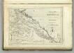
Map of Abyssinia.
1 : 1470000 Melish, John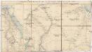
Stanford's popular map of the seat of military operations in the Súdan
1 : 1450000 Chartúm (Súdán) Stanford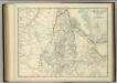
Upper Nubia and Abyssinia.
1 : 2854868 Johnston, W. & A.K.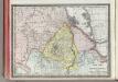
Upper Nubia and Habesh or Abyssina.
1 : 5000000 Rand McNally and Company
Golfe arabique ou mer rouge
1 Karte : Kupferdruck ; 66 x 47 cm Anville s.n.