Maps of Ethiopian Highlands
Upper Nubia and Abyssinia.
1 : 2854868 Johnston, Alexander Keith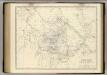
Nubia, Abyssinia.
1 : 2854868 Johnston, Alexander Keith, 1804-1871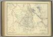
Upper Nubia and Abyssinia.
1 : 2854868 Johnston, Alexander Keith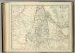
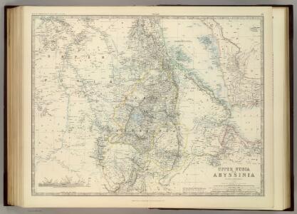
Upper Nubia and Abyssinia.
1 : 2854868 Johnston, W. & A.K.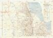
Seconda edizione della nuova carta dei domini e protettorati italiani nell' Eritrea e regioni limitrofe
1 : 1500000 Eritrea Ministero della guerra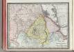
Upper Nubia and Habesh or Abyssina.
1 : 5000000 Rand McNally and Company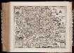
Habessinia seu Abassia, presbyteri Johannis regio perperam dicta ... / Jobi Lodolfi [cart.] ; Christianus Ludolfus J. Filius delineavit ex autographo Parentis
1 : 2400000 Annotatie: Origineel is Blad 211 in atlas factice Jobus Ludolphus 1624-1704; Christianus Ludolfus [Amsterdam] : [s.n.]
Abyssinia, surrounding countries.
1 : 6450000 Rand McNally and Company
Carta della colonia Eritrea coll'Abissinia : e regioni limitrofe tra il Nilo, Suakin e il Golfo d'Aden
1 : 4000000 Cora, Guido, 1851-1917 Fratelli Bocca
Countries In The Northern Tropical Regions of Africa.
Fullarton, A. & Co.
Carte d'Abyssinie et des contrées adjacentes dressée partie d'après des observations faites sur les lieux par l'auteur, partie d'après les informations prises dans le pays en 1809 et 1810
1 : 5000000 par Henry Salt [S.l.] : [s.n.]
Karte von Aethiopien (H'abeš, Takah & Ost-Senar)
1 : 2500000 Eritrea Heuglin, Theodor von Bruce Hermann Costenoble
Sennaar. Afrique 25.
1 : 1641836 Vandermaelen, Philippe, 1795-1869
Carte générale d'Abyssinie
1 : 1800000 dressée par M. le lieutenant de vaisseau Théophile Lefebvre pendant son voyage d'exploration en 1839, 40, 41, 42, 43 Paris : Arthus Bertrand
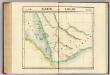
Nubia and Abyssinia to Bab El Mandeb.
1 : 3380000 Sharpe, J.
Jobi Ludolfi Habessinia seu Abassia, presbyteri Johannis regio
Etiopie Ludolf, Christian Habess, Gregorius
Carte de l'Abyssinie, du pays des Galla, de Choa et d'Ifat
1 : 2500000 dressée par Mrs. Combes et Tamisier dessinée par A. Vuillemin ; gravée par Massuet ; écrite par Martin ainé Paris : Desessart
Carta della colonia Eritrea
1 : 1500000 Italie. Ministero degli Affari esteri [Florence] : Ministero degli affari esteri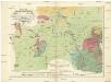
Geognostiche Karte von ost Sudan, umfaßsend dei Länder Kordofan, Nuba, Sennaar, Roserres, Faßsokl und el Pert nebst den angrenzenden Theilen von Dar Fur, Nubien, Ab eßsinien und den Galla Ländern
1 : 1800000 Etiopie E. Schweizerbart'schen Buchhandlung
1re partie de la Carte de la Mer Rouge
1 : 2500000 Rudé moře-oblast
KARTE VON OST SUDAN
1 : 1800000 Dárfúr (Súdán) Russegger, Joseph E. Schweiyerbart'schen Buchhandlung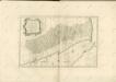

Liberia (1914)
Liberia, TSGS 2083. Great Britain. General Staff. Topographical Section. [London] : [TSGS, War Office]
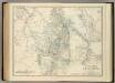
Abissinie. Afrique 32.
1 : 1641836 Vandermaelen, Philippe, 1795-1869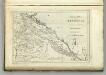
Map of Abyssinia.
1 : 1470000 Melish, John
Karte von dem groessten Theil des Landes Jemen Imame, Kaukeban &
1 : 775000 Jemen Niebuhr, Carsten Benedicti, Hieronymus F.A. Schraembl
Terrae Yemen maxima pars, seu imperii Imami, principatus Kaukebân, nec non ditionum Haschid u Bekîl, Nehhm, Chaulân, Abu Arîsch et Aden, tabula : ex observationibus astronomicis et hodometricis jussu et sumtibus potentissimor. Daniae regum Friderici V, et Christiani VII. institutis, delineata
1 : 1200000 auctore C. Niebuhr Gustav Conrad Lotter sculps. Aug. Vind. : Tob. Conr: Lotter geogr. excud.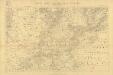
Carta dimostrativa della Etiopia (Sheet 5)
Carta dimostrativa della Etiopia, in 6 fogli e 2 aggiunte, alla scala di 1 : 100,000. Compilata dal Capitano ... Ethiopia de Chaurand, etc. [Rome]
Terrae Yemen maxima Pars. seu Imperii Imami, Principatus Kaukebân, nec non ditionum Haschid U Bekîl, Nehhm, Chaulân, Abu Arîsch Et Aden Tabula : ex observationibus astronomicis et hodometricis jussu et suntibus Potentissimor: Daniae Regnum Friderici V et Christiani VII institutis
1 : 1250000 Niebuhr, Carsten, 1733-1815 Tob. Conr. Lotter