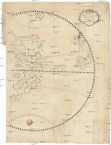
Maps of North America

Pars globi terrestris
země světa Murr, Christoph Gottlieb von Behaim, Martin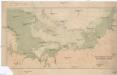
Cesta norské výpravy na severní točnu 1893-1896
1 : 12000000 Arktida nákladem J. Otty
Fysikální mapa severních polárních zemí
1 : 14000000 Arktida Bartholomew, J. G. Nansen, Fridtjof nákladem J. Otty
Sovětský svaz v mapách
Septentrionalium Terrarum descriptio. [Karte] Frislant insula [Nebenkarte] Farre insulae [Nebenlarte] Scetland insulae [Nebenlarte], in: Gerardi Mercatoris Atlas, sive, Cosmographicae meditationes de fabrica mundi et fabricati figura, S. 76.
1 Karte aus Atlas Mercator, Gerhard Montanus, Petrus
Nordpolargebiete
1 : 20000000 Arktida Velhagen & Klasing
Physical map of the Arctic
1 : 20000000 Arktida American geographical society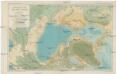
Bathymetric map of the Arctic basin
1 : 20000000 Severní ledový oceán Nansen, Fridtjof American geographical society
Nord-Polar-Karte
1 : 20000000 Arktida Berghaus, Heinrich Karl Wilhelm Habenicht, Hermann Justus Perthes
Nansen's Nordpolfahrt 1893-1896
1 : 30000000 Arktida Umlauft, Friedrich Kartogr. Anstalt von G. Freytag & Berndt
Carta delle Terre polari Artiche
1 : 11800000 Arktida Miniscalchi-Erizzo, Francesco P. Ripamonti Carpano
Essai d'une carte polaire arctique
1 Karte : Kupferdruck ; Durchmesser 46 cm Robert de Vaugondy; Dussy chés l'auteur quai de l'horloge du Palais près le Pont neuf
[140][143] Poli Arctici ..., uit: Atlas sive Descriptio terrarum orbis
Annotatie: Gedigitaliseerde versie. Amsterdam. Heiloo : Picturae (vervaardiger), 2015. tiff-bestand. Gedigitaliseerd: 07-01-2015; Origineel: Universiteitsbibliotheek Vrije Universiteit (XL.05127.-) ; Netherlands; Titelpagina ontbreekt Wit, Frederik de Amsterdam : Frederick de Wit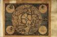
Septentrionalivm terrarum descriptio
1 Karte : Kupferdruck ; Durchmesser 17 cm, Bildgrösse 18 x 25 cm Mercator Cloppenburgh
Septentrionalivm terrarum descrıptio
1 Karte : Kupferdruck ; Durchmesser 34 cm, Bildgrösse 35 x 38 cm Mercator; Hondius Jodocus Hondius
Septentrionalivm terrarum descrıptio
1 Karte : Kupferdruck ; Durchmesser 34 cm, Bildgrösse 35 x 38 cm Mercator s.n.
Polvs arcticvs siue tract[us] septentrionalis
1 Karte : Kupferdruck ; Durchmesser 21 cm, Bildgrösse 22 x 28 cm Quad; Bussemacher ex officina typographica Jani Bussemechers
Polar-Karte
1 : 27000000 Arktida Stieler, Adolf Justus Perthes
Map of the countries round the North Pole
1 : 15000000 Arktida Arrowsmith, John John Arrowsmith
A new [and] accurate map of the North Pole
1 Karte : Kupferdruck ; 37 x 40 cm Bowen s.n.
Poli arctici, et circumiacentium terrarum descriptio novissima
1 Karte : Kupferdruck ; Durchmesser 43 cm, Bildgrösse 43 x 49 cm Wit Louis Renard
Nova et accvrata poli arctici et terrarum circum iacentium descriptio
1 Karte : Kupferdruck ; 40 x 52 cm Janssonius apud Ioannem Ianssonium
Nova et accvrata poli arctici et terrarum circum iacentium descriptio
1 Karte : Kupferdruck ; 39 x 51 cm Valck; Schenk apud Gerardi Valk et Petri Schenk
Poli arctici, et circumiacentium terrarum descriptio novissima
1 Karte : Kupferdruck ; Durchmesser 42 cm, Bildgrösse 43 x 49 cm Wit by Frederick de Wit in de Calverstraet aen den Dam in de Witte Pascaert
Regiones svb polo arctico
1 Karte : Kupferdruck ; 40 x 52 cm Blaeu Blaeu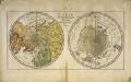
Carte des deux regions polaires
2 Karten auf einem Blatt : Kupferdruck ; Durchmesser je 20 cm Lange; Berndt s.n.
Nova et accvrata Poli Arctici et terrarum circum iacentium descriptio
1 : 17500000 Annotatie: Rechtsboven: IV; Origineel is Blad 148 in atlas factice Amstelodami : apud Ioannem Ianßonium
Poli Arctici, Et Circumiacentium Terrarum Descriptio Novissima. [Karte], in: Gerardi Mercatoris et I. Hondii Newer Atlas, oder, Grosses Weltbuch, Bd. 1, S. 42.
1 Karte aus Atlas Mercator, Gerhard und Hondius, Jodocus Jansson, Jan
Bez titulu: Skládací glóbus

Die westliche Halbkugel
1 Karte : Kupferdruck ; Durchmesser 51 cm Arrowsmith in der kayserlichen privilegirten Kunst und Buchhandlung bey Ad. Gottl. Schneider und Weigel
Westliche Halb Kugel
1 Karte : Kupferdruck ; Durchmesser 60 cm Anville; Schrämbl; Benedicti zu finden im eigenen Verlage Schrämbl
Hemisphere occidental
1 Karte : Kupferdruck ; Durchmesser 48 cm L'Isle; Buache; Dezauche chez Dezauche successeur des S.rs De l'Isle et Buache et seul chargé de l'entrepôt général des cartes de la marine rue des Noyers
Hémisphère occidental
1 Karte : Kupferdruck ; Durchmesser 37 cm Lotter; Lotter Lotter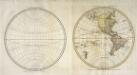
Western hemisphere
1 Karte : Kupferdruck ; Durchmesser 34 cm Faden; Jefferys publish'd by Jefferys and Faden corner of St. Martins lane Charing Cross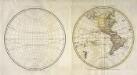
Western hemisphere
1 Karte : Kupferdruck ; Durchmesser 34 cm Faden William Faden the corner of St. Martins lane
Hémisphère occidental ou du nouveau monde
1 Karte : Kupferdruck ; Durchmesser 61 cm Anville; Delahaye chés l'aut.r aux galeries du Louvre