Maps of North America
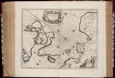
Nova et accvrata Poli Arctici et terrarum circum iacentium descriptio
1 : 17500000 Annotatie: Rechtsboven: IV; Origineel is Blad 148 in atlas factice Amstelodami : apud Ioannem Ianßonium
River Ice in Relation to Navigation, Average Annual Number of Days with Ice.
U.S. Navy
Ice Chart, Northern Hemisphere, April.
U.S. Navy
Ice Chart, Northern Hemisphere, October.
U.S. Navy
Polar Regions.
1 : 35000000 Philip, George
3. Terre polari.
1 : 45000000 Touring club italiano
Polar-Karte enthaltend: die Lander u. Meere vom Nord-Pol bis 50 degrees N.
1 : 29000000 Stieler, Adolf
Carta generale del Polo Artico.
1 : 22500000 Marzolla, Benedetto
Hémisphère septentrional
1 Karte : Kupferdruck ; Durchmesser 44 cm L'Isle; Buache; Dezauche chez l'auteur successeur des S.rs De l'Isle et Phil. Buache ... rue des Noyers
Nördliche Oberflaeche der Erde
1 Karte : Kupferdruck ; Durchmesser 47 cm Funk; Frentzel s.n.
Noerdliche Erd=Oberflaeche
1 Karte : Kupferdruck ; Durchmesser 60 cm Funk; Frentzel s.n.
Emisfero terrestre settentrionale
1 Karte : Kupferdruck ; Durchmesser 29 cm, Bildgrösse 32 x 41 cm Zatta; Zuliani; Pitteri presso Antonio Zatta
Hemisphere septentrional
1 Karte : Kupferdruck ; Durchmesser 44 cm Redern s.n.
Hemisphere septentrional
1 Karte : Kupferdruck ; Durchmesser 43 cm Redern s.n.
Carte du globe terrestre où les terres de l'hemisphere merid.l sont supposées être vues à travers celles de l'hemisphere septent.l
1 Karte : Kupferdruck ; Durchmesser 23 cm, Blattgrösse 46 x 61 cm Buache; Delahaye chés l'auteur sur le quay de l'Horloge
L'Hemisphere septentrional
1 Karte : Kupferdruck ; Durchmesser 43 cm L'Isle; Kirilov chez Jean Cóvens et Corneille Mortier libraires
L'Hemisphere septentrional
1 Karte : Kupferdruck ; Durchmesser 43 cm L'Isle; Kirilov chez Jean Cóvens et Corneille Mortier libraires
Hemisphere septentrional
1 Karte : Kupferdruck ; Durchmesser 44 cm L'Isle; Kirilov; Ottens; Ottens chez R. und I. Ottens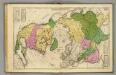
North America, Asia.
1 : 43000000 Woodbridge, William C.
Regiones Sub Polo Arctico. [Karte], in: Novus Atlas, das ist, Weltbeschreibung, Bd. 1, S. 19.
1 Karte aus Atlas Blaeu, Joan Blaeu, Willem Janszoon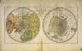
Carte des deux regions polaires
2 Karten auf einem Blatt : Kupferdruck ; Durchmesser je 20 cm Lange; Berndt s.n.
North Polar Regions.
1 : 22000000 Rand McNally and Company
[Ergänzungen und Berichtungen]
Geographischer Atlas über alle Theile der Erde Ziegler, Jakob Melchior Verlag von Dietrich Reimer
The Arctic regions
1 : 14673400 Arktida National Geographic Society
Regiones Sub Polo Arctico. [Karte], in: Le théâtre du monde, ou, Nouvel atlas contenant les chartes et descriptions de tous les païs de la terre, Bd. 1, S. 33.
1 Karte aus Atlas Blaeu, Willem Janszoon und Blaeu, Joan Blaeu, Willem Janszoon
Northern Regions.
1 : 22176000 Colton, G.W.
TARTARIA | sive | MAGNI CHAMI | IMPERIVM.
[Amsterdam : Joan Blaeu]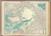
North Polar regions.
1 : 14000000 John Bartholomew and Son
Die allmaehlige Bildung des Russichen Reiches seit der MItte des XVten Jahrhundert's
1 : 40000000 Russland Expansion
Polar-Karte
1 : 27000000 Arktida Stieler, Adolf Justus Perthes
Map of the countries round the North Pole
1 : 15000000 Arktida Arrowsmith, John John Arrowsmith
A new [and] accurate map of the North Pole
1 Karte : Kupferdruck ; 37 x 40 cm Bowen s.n.
Poli arctici, et circumiacentium terrarum descriptio novissima
1 Karte : Kupferdruck ; Durchmesser 43 cm, Bildgrösse 43 x 49 cm Wit Louis Renard
Nova et accvrata poli arctici et terrarum circum iacentium descriptio
1 Karte : Kupferdruck ; 40 x 52 cm Janssonius apud Ioannem Ianssonium
Nova et accvrata poli arctici et terrarum circum iacentium descriptio
1 Karte : Kupferdruck ; 39 x 51 cm Valck; Schenk apud Gerardi Valk et Petri Schenk
Poli arctici, et circumiacentium terrarum descriptio novissima
1 Karte : Kupferdruck ; Durchmesser 42 cm, Bildgrösse 43 x 49 cm Wit by Frederick de Wit in de Calverstraet aen den Dam in de Witte Pascaert