Maps of Czech Republic

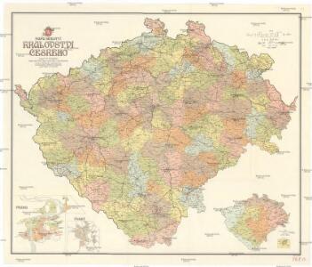
Mapa školství Království českého
1 : 460000 Čechy (Česko) Mařatka, František Zemský ústřední spolek jednot učitelských v Král. českém
Uebersichts-Karte über die Verbreitung der Spar- und Darlehenscassen-Vereine, landw. Lagerhäuser, und Molkerei-Genossenschaften im deutschen Sprachgebiete Böhmens
Sudety (Česko) A. Haase
Karten zur Statistik des Königreiches Böhmen...

Geologická mapa Království Českého

Karte der Kreisgerichts-Sprengel und Gerichts-Bezirke des Königreiches Böhmen
1 : 600000 Čechy (Česko) Hickmann, Anton L. von A.L. Hickmann
Übersichtskarte der Gebiete für die landwirthschaftlichen Regional-Ausstellungen in Boehmen
Čechy (Česko) von der k.k. patriotisch-oekonomischen Gesellschaft
Post Karte vom Königreiche Böhmen
Čechy (Česko) Eckert, F. Sartorius, Johann Christoph
Mapa Království českého
1 : 500000 Čechy (Česko) z uměleckého závodu Eduarda Hölzela
Karten zur Statistik des Königreiches Böhmen...

Bez titulu: Statistické mapky Čech

Neueste Reisekarte von Böhmen
1 : 600000 Česko Wagner, Jan Eduard F. Kytka
Statistisch topographische Karte des Kronlandes Boehmen
1 : 800000 Německo Steingruber, Konrad Riedl, Johann Baptist Joh. Stiasny
Bohemia
1 : 750000 Sudety (Česko)
Bohemia
1 : 750000 Sudety (Česko)
Politická a místopisná mapa Království českého
1 : 418000 Česko Erben, Josef nákladem kněhkupectví K. Janského
Politická a místopisná mapa Království českého
1 : 418000 Česko Erben, Josef Smolík, Ott. nákladem kněhkupectví K. Janského
Politická a místopisná mapa Království českého
1 : 418000 Česko Erben, Josef Smolík, Ott. nákladem kněhkupectví K. Janského
General-Uibersichts-Karte des Königreiches Böhmen
1 : 575000 Česko Windisch-Graetz, Alfred Kandidus C. Hennig u. F. Tempsky
General-Uibersichts-Karte des Königreiches Böhmen
1 : 575000 Česko Windisch-Graetz, Alfred Kandidus C. Hennig u. F. Tempsky
Strassen-Uebersichtskarte von Böhmen
1 : 665000 Česko
Strassen-Uebersichtskarte von Böhmen
1 : 665000 Česko
Karten zur Statistik des Königreiches Böhmen

Čechy
1 : 1000000 Česko Ústřední nakladatelství a knihkupectví učitelstva československého
General-Karte von Böhmen
1 : 500000 Česko R. Lechner (Wilh. Müller)
General-Karte von Böhmen
1 : 500000 Česko R. Lechner (Wilh. Müller)
Karte der Bevölkerungsdichte (relative Bevölkerung) des Königreiches Böhmen
1 : 600000 Česko Hickmann, Anton L. A.L. Hickmann
Vodopisná mapka Čech
1 : 902000 Česko
Isochronická mapa Čech
1 : 750000 Česko Nový, Václav Václav Nový
Isochronická mapa Čech
1 : 750000 Česko Nový, Václav Klub českých turistů
Karte des oesterreichischen Kronlandes Böhmen
Čechy (Česko) Adam, Jakob Friedr. Kretzschmar