Maps of Czech Republic

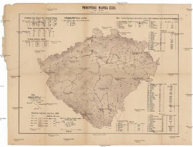
Vodopisná mapka Čech
1 : 902000 Česko
Karte des oesterreichischen Kronlandes Böhmen
Čechy (Česko) Adam, Jakob Friedr. Kretzschmar
Karte des oesterreichischen Kronlandes Böhmen
Čechy (Česko) Fils Kretzschmar, Friedrich Friedr. Kretzschmar
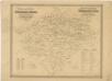
Bohemia
1 : 750000 Sudety (Česko)
Bohemia
1 : 750000 Sudety (Česko)
Uebersichts-Karte über die Verbreitung der Spar- und Darlehenscassen-Vereine, landw. Lagerhäuser, und Molkerei-Genossenschaften im deutschen Sprachgebiete Böhmens
Sudety (Česko) A. Haase
Karte der Kreisgerichts-Sprengel und Gerichts-Bezirke des Königreiches Böhmen
1 : 600000 Čechy (Česko) Hickmann, Anton L. von A.L. Hickmann
Übersichtskarte der Gebiete für die landwirthschaftlichen Regional-Ausstellungen in Boehmen
Čechy (Česko) von der k.k. patriotisch-oekonomischen Gesellschaft
Post Karte vom Königreiche Böhmen
Čechy (Česko) Eckert, F. Sartorius, Johann Christoph
Isochronická mapa Čech
1 : 750000 Česko Nový, Václav Václav Nový
Isochronická mapa Čech
1 : 750000 Česko Nový, Václav Klub českých turistů
Čechy
1 : 1000000 Česko Ústřední nakladatelství a knihkupectví učitelstva československého
General-Karte von Böhmen
1 : 500000 Česko R. Lechner (Wilh. Müller)
General-Karte von Böhmen
1 : 500000 Česko R. Lechner (Wilh. Müller)
Karte der Bevölkerungsdichte (relative Bevölkerung) des Königreiches Böhmen
1 : 600000 Česko Hickmann, Anton L. A.L. Hickmann
Böhmen
Čechy (Česko) Trausel, W. Steyrer, Fr. C.
Karten zur Statistik des Königreiches Böhmen...

Mapa poštovních spojů v Čechách
1 : 400000 Pardubice (Česko : oblast) Ministerstvo pošt a telegrafů
Mapa poštovních spojů v Čechách
1 : 400000 Česko Pachman, Josef Ministerstvo pošt a telegrafů
Přehledná mapa železniční Království českého
1 : 600000 Česko Zemský výbor
Přehledná mapa železniční Království českého
Česko Zemský výbor
Království české
1 : 570000 Česko Wagner, Jan Eduard Jan Ed. Wagner
Království české
1 : 570000 Česko Wagner, Jan Eduard Jan Ed. Wagner
Království české
1 : 570000 Česko Wagner, Jan Eduard Jan Ed. Wagner
Království české
1 : 570000 Česko Wagner, Jan Eduard Jan Ed. Wagner
Karte des Königreich's Boehmen
1 : 415000 Česko Friedrich Kretzschmar
Země česká
Archeologická mapa království Českého

Železniční a silniční mapa Království Českého
1 : 525000 Česko Wagner, Jan Eduard F. Kytka