Maps of Islington

Insurance Plan of London Vol. VI: sheet 131
1 : 480 This detailed 1887 plan of London is one of a series of twenty-seven sheets in an atlas originally produced to aid insurance companies in assessing fire risks. The building footprints, their use (commercial, residential, educational, etc.), the number of floors and the height of the building, as well as construction materials (and thus risk of burning) and special fire hazards (chemicals, kilns, ovens) were documented in order to estimate premiums. Names of individual businesses, property lines, and addresses were also often recorded. Together these maps provide a rich historical shapshot of the commercial activity and urban landscape of towns and cities at the time. The British Library holds a comprehensive collection of fire insurance plans produced by the London-based firm Charles E. Goad Ltd. dating back to 1885. These plans were made for most important towns and cities of the British Isles at the scales of 1:480 (1 inch to 40 feet), as well as many foreign towns at 1:600 (1 inch to 50 feet). Chas E Goad Limited Chas E Goad Limited
PLAN of a BREWERY AND PREMISES situate in St. John's Street, Clerkenwell - to be sold by Action- by Shuttleworth and Stevens March 5, 1818
1 : 360 This is a plan of a brewery in St John's Street, Clerkenwell to be sold at action. The different pastel colours denote the different lots to be sold.
Insurance Plan of London Vol. VI: sheet 130
1 : 480 This detailed 1887 plan of London is one of a series of twenty-seven sheets in an atlas originally produced to aid insurance companies in assessing fire risks. The building footprints, their use (commercial, residential, educational, etc.), the number of floors and the height of the building, as well as construction materials (and thus risk of burning) and special fire hazards (chemicals, kilns, ovens) were documented in order to estimate premiums. Names of individual businesses, property lines, and addresses were also often recorded. Together these maps provide a rich historical shapshot of the commercial activity and urban landscape of towns and cities at the time. The British Library holds a comprehensive collection of fire insurance plans produced by the London-based firm Charles E. Goad Ltd. dating back to 1885. These plans were made for most important towns and cities of the British Isles at the scales of 1:480 (1 inch to 40 feet), as well as many foreign towns at 1:600 (1 inch to 50 feet). Chas E Goad Limited Chas E Goad Limited
London VII.45 - OS London Town Plan
1 : 1056 Topographic maps Ordnance Survey Ordnance Survey
Trade Card Map of St Johns, Clerkenwell
Smith and Bye
The Parish of St. JAMES CLERKENWELL Taken from ye last Survey With Corrections
1 : 3840 This is the second edition of the plan of the parish of St. James, Clerkenwell by Richard Blome. Sadler's Well's is marked on the map near the top of the sheet. Built in 1683, at the time of the publication of this map, it was little more than a small music hall acting as a side attraction to a medicinal spa. Although visited by 500 people a day at the height of the spa's popularity, by 1687 it had fallen into disrepair. It was restored in 1746 by a local builder, Thomas Rosoman. Blome, Richard
Insurance Plan of London Vol. VI: Key Plan 1
1 : 480 This "key plan" indicates coverage of the Goad 1887 series of fire insurance maps of London that were originally produced to aid insurance companies in assessing fire risks. The building footprints, their use (commercial, residential, educational, etc.), the number of floors and the height of the building, as well as construction materials (and thus risk of burning) and special fire hazards (chemicals, kilns, ovens) were documented in order to estimate premiums. Names of individual businesses, property lines, and addresses were also often recorded. Together these maps provide a rich historical shapshot of the commercial activity and urban landscape of towns and cities at the time. The British Library holds a comprehensive collection of fire insurance plans produced by the London-based firm Charles E. Goad Ltd. dating back to 1885. These plans were made for most important towns and cities of the British Isles at the scales of 1:480 (1 inch to 40 feet), as well as many foreign towns at 1:600 (1 inch to 50 feet). Chas E Goad Limited Chas E Goad Limited
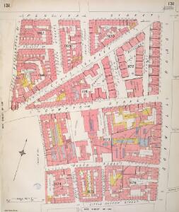
Insurance Plan of London Vol. VI: sheet 133
1 : 480 This detailed 1887 plan of London is one of a series of twenty-seven sheets in an atlas originally produced to aid insurance companies in assessing fire risks. The building footprints, their use (commercial, residential, educational, etc.), the number of floors and the height of the building, as well as construction materials (and thus risk of burning) and special fire hazards (chemicals, kilns, ovens) were documented in order to estimate premiums. Names of individual businesses, property lines, and addresses were also often recorded. Together these maps provide a rich historical shapshot of the commercial activity and urban landscape of towns and cities at the time. The British Library holds a comprehensive collection of fire insurance plans produced by the London-based firm Charles E. Goad Ltd. dating back to 1885. These plans were made for most important towns and cities of the British Isles at the scales of 1:480 (1 inch to 40 feet), as well as many foreign towns at 1:600 (1 inch to 50 feet). Chas E Goad Limited Chas E Goad Limited
PLAN of the ESTATE of Thos Seckford, Esq. Lying in Clerkenwell, in the County of Middlesex; Given for the Support of his ALMS -HOUSES AT WOODBRIDGE, in Suffolk. 1587. (Taken in 1764)
1 : 1476 This is a plan of Thomas Seckford's estate in Clerkenwell. A note at bottom left states that the estate is to be leased in 6 parts for 60 years each. It seems that there was intention to colour the plan as the key refers to colours. ''New Prison'' is marked just left of the cartouche. Clerkenwell Bridewell was built in 1616 as an overflow for Bridewell and was hence known as ''New Prison''. An additional ''New Prison'' was built adjacent to it later in the century to relieve pressure on Newgate. Lowell
Insurance Plan of London North District Vol. D: sheet 15
1 : 480 This detailed 1901 plan of London is one of a series of twenty sheets in an atlas originally produced to aid insurance companies in assessing fire risks. The building footprints, their use (commercial, residential, educational, etc.), the number of floors and the height of the building, as well as construction materials (and thus risk of burning) and special fire hazards (chemicals, kilns, ovens) were documented in order to estimate premiums. Names of individual businesses, property lines, and addresses were also often recorded. Together these maps provide a rich historical shapshot of the commercial activity and urban landscape of towns and cities at the time. The British Library holds a comprehensive collection of fire insurance plans produced by the London-based firm Charles E. Goad Ltd. dating back to 1885. These plans were made for most important towns and cities of the British Isles at the scales of 1:480 (1 inch to 40 feet), as well as many foreign towns at 1:600 (1 inch to 50 feet). Chas E Goad Limited Chas E Goad Limited
Insurance Plan of London Vol. VI: sheet 132
1 : 480 This detailed 1887 plan of London is one of a series of twenty-seven sheets in an atlas originally produced to aid insurance companies in assessing fire risks. The building footprints, their use (commercial, residential, educational, etc.), the number of floors and the height of the building, as well as construction materials (and thus risk of burning) and special fire hazards (chemicals, kilns, ovens) were documented in order to estimate premiums. Names of individual businesses, property lines, and addresses were also often recorded. Together these maps provide a rich historical shapshot of the commercial activity and urban landscape of towns and cities at the time. The British Library holds a comprehensive collection of fire insurance plans produced by the London-based firm Charles E. Goad Ltd. dating back to 1885. These plans were made for most important towns and cities of the British Isles at the scales of 1:480 (1 inch to 40 feet), as well as many foreign towns at 1:600 (1 inch to 50 feet). Chas E Goad Limited Chas E Goad Limited
Insurance Plan of London Vol. VI: sheet 138
1 : 480 This detailed 1887 plan of London is one of a series of twenty-seven sheets in an atlas originally produced to aid insurance companies in assessing fire risks. The building footprints, their use (commercial, residential, educational, etc.), the number of floors and the height of the building, as well as construction materials (and thus risk of burning) and special fire hazards (chemicals, kilns, ovens) were documented in order to estimate premiums. Names of individual businesses, property lines, and addresses were also often recorded. Together these maps provide a rich historical shapshot of the commercial activity and urban landscape of towns and cities at the time. The British Library holds a comprehensive collection of fire insurance plans produced by the London-based firm Charles E. Goad Ltd. dating back to 1885. These plans were made for most important towns and cities of the British Isles at the scales of 1:480 (1 inch to 40 feet), as well as many foreign towns at 1:600 (1 inch to 50 feet). Chas E Goad Limited Chas E Goad Limited
A PLAN OF THE ROADS AND STREETS From Islington to Dog House Bar Delineated to Show A NEW ROAD intended Cross the Fields from Islington to the said Dog House Bar 41 C
1 : 9600 This small plan was published in the London Magazine in 1760.The title appears at bottom left, with scale bars at bottom right and compass star at top right. The intended extension from Angel to Old Street is indicated by a double dotted line, with St. Luke's Church represented pictorially. Built by the Duke of Grafton in 1756 to drive cattle east to Smithfield Market, avoiding Holborn and Oxford Street, this was the capital's first bypass. London Magazine
London (1915- Numbered sheets) V.6 (includes: Finsbury; Holborn; Islington; St Pancras) - 25 Inch Map
1 : 2500 Topographic maps Ordnance Survey Ordnance Survey
London (First Editions c1850s) XXVI (includes: Finsbury; Holborn; Islington; St Pancras) - 25 Inch Map
1 : 2500 Topographic maps Ordnance Survey Ordnance Survey
Insurance Plan of London North District Vol. D (Key C): sheet 3-1
1 : 480 This detailed 1901 plan of London is one of a series of twenty sheets in an atlas originally produced to aid insurance companies in assessing fire risks. The building footprints, their use (commercial, residential, educational, etc.), the number of floors and the height of the building, as well as construction materials (and thus risk of burning) and special fire hazards (chemicals, kilns, ovens) were documented in order to estimate premiums. Names of individual businesses, property lines, and addresses were also often recorded. Together these maps provide a rich historical shapshot of the commercial activity and urban landscape of towns and cities at the time. The British Library holds a comprehensive collection of fire insurance plans produced by the London-based firm Charles E. Goad Ltd. dating back to 1885. These plans were made for most important towns and cities of the British Isles at the scales of 1:480 (1 inch to 40 feet), as well as many foreign towns at 1:600 (1 inch to 50 feet). Chas E Goad Limited Chas E Goad Limited
PLAN of the CITY ROAD
1 : 4800 Survey of the City Road, London, from the Angel Inn in Islington to Finsbury Square with title and imprint at top left, compass in the centre, scale bar at bottom right and note on paving of Finsbury Square at lower right. Wickings, W.
Insurance Plan of London: sheet 6
This detailed 1889 plan of London is one of a series of six sheets in an atlas originally produced to aid insurance companies in assessing fire risks. The building footprints, their use (commercial, residential, educational, etc.), the number of floors and the height of the building, as well as construction materials (and thus risk of burning) and special fire hazards (chemicals, kilns, ovens) were documented in order to estimate premiums. Names of individual businesses, property lines, and addresses were also often recorded. Together these maps provide a rich historical shapshot of the commercial activity and urban landscape of towns and cities at the time. The British Library holds a comprehensive collection of fire insurance plans produced by the London-based firm Charles E. Goad Ltd. dating back to 1885. These plans were made for most important towns and cities of the British Isles at the scales of 1:480 (1 inch to 40 feet), as well as many foreign towns at 1:600 (1 inch to 50 feet). Chas E Goad Limited Chas E Goad Limited
A New and Accurate SURVEY of the PARISHES of St. Andrews Holbourn
Plan of the parishes of St. Andrew's, Holborn, St George's, Queen Square, St James's Clerkenwell, St Luke's, Old Street, St Mary's Islington and the Charterhouse Liberty. Cole, B.
A new and exact plan of the city of London and suburbs thereof, 2
1 Blatt : 60 x 51 cm Henry Overton
Englands glory, or, the glory of England being a new mapp of the city of London : shewing the remarkable streets, lanes, alleyes, churches, halls courts, and other places as they are now rebuilt, the which will therefore be a guide to strangers, and such as are not well acquainted herein to direct them from place to place : diverse faults y[t] are in y[e] former are in this amended, allsoe the severall figures y[t] stand up and downe in the mapp are explained in y[e] 2 tables at y[e] upper corners hereof.
Walton, Robert, 1618-1688 Robert Walton
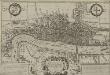
LONDON and WESTMINSTER in the Reign of QUEEN ELIZABETH, Anno Dom. 1563 25
This retrospective map of Elizabethan London was produced in the 1820s. It provides us with an idea of how people in the19th century viewed the Elizabethan city. The location of Tower Bridge is indicated on this map, even though plans for the actual bridge were not made until 1879. Neele, George
London VII.NW - OS Six-Inch Map
1 : 10560 Topographic maps Ordnance Survey Ordnance Survey
LONDON FERACISSIMI ANGLIAE REGNI METROPOLIS
The title of this map of London appears at the top of the plate, flanked by Tudor and city arms. A note on the history of London features at bottom left and on the Steelyard at bottom right. Illustrated figures of merchants appear at bottom centre. Published in 'Civitates Orbis Terrarum', the map is similar in detail to the 'Copperplate Map', the earliest printed map of London of which no complete copy survives. Merchant ships, cranes, mills, bull and bear baiting pits, the large tennis courts at Westminster and the stags in St. James’s are examples of London business and leisure activities. Walled gardens, elegant churches and livery halls testify to the high quality of life enjoyed by its citizens. Braun, Georg & Hogenberg, Frans
Handy Reference Atlas of London
Edinburgh : John Bartholomew & Co.,
A New PLAN of the CITY and LIBERTY of WESTMINSTER, Exhibiting all the New Streets & Roads, with the Residences of the Principal Nobility, Public Offices, &c. Not extant in any other Plan.
This map is by Thomas Jeffreys, an exceptional cartographer and publisher whose productions, including maps of North America, are considered to be among the finest of his age. This map shows the new developments in Westminster by use of a colour coding system indicating varying stages of completion. Portman Square (W1), a contemporary development, was begun the year before this map was published. It was built between 1764 and 84 for the landlord Henry William Portman on what was then considered the outskirts of town. Thomas Jeffreys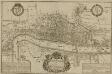
A Plan of London, Westminst.r and Southwark
This is derivative of Hatton's edition of Braun & Hogenberg's map-view of London. Unusually for a map of its time, most of the buildings are represented in plan instead of pictorially. The Latin text at the foot of the plate in the original are replaced by notes, in English, on the geographic and demographic growth of the city. Braun, Georg & Hogenberg, Frans
A NEW PLAN of the CITY of LONDON and BOROUGH OF SOUTHWARK, Exhibiting all the New Streets & Roads &c. Not extant in any other Plan.
1 : 14080 Thomas Jeffreys was an exceptional cartographer and publisher whose productions included maps of North America, considered to be among the finest of the time.This map of the City of London and the Borough of Southwark shows important buildings such as the Tower of London and St Paul's in plan form, differing from many earlier examples, which show them in elevation. It is dedicated to the Right Honourable Lord Mayor Aldermen and to the Commissioners of the Sewers, Lamps and Pavements. Jeffreys, Thomas
LONDINUM FERACISSIMI ANGLIAE REGNI METROPOLIS
This derivative of Braun & Hogenberg's 1572 map of London was published in Belle Forest's 'La Cosmographie universelle de tout le monde'. The map's title features at the top of the plate, flanked by Tudor and city arms. Descriptive notes in French appear at bottom left and bottom right, with figures of merchants at bottom centre. The map is similar in detail to the 'Copperplate Map', the earliest printed map of London of which no complete copy survives. Merchant ships, cranes, mills, bull- and bear-baiting pits, the large tennis courts at Westminster and the stags in St. James’s are examples of London business and leisure activities. Walled gardens, elegant churches and livery halls testify to the high quality of life enjoyed by its citizens. Braun, Georg & Hogenberg, Frans