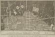
Maps of Islington

Handy Reference Atlas of London
Edinburgh : John Bartholomew & Co.,
Charles Booth's 'Descriptive Map of London Poverty'. Detail showing the City of London and the East End
The East End of London is the hell of poverty. Like one enormous black, motionless giant kraken, the poverty of London lies there in lurking silence and encircles with its mighty tentacles the life and wealth of the City. So wrote J H Mackay in 1891. It was acknowledged that the blame lay with overcrowded housing and with a surplus of labour, which kept wages low for those lucky enough to find work. Statistics for 1888 showed that the East End had 8,465 official paupers - people 'living rough'. According to Charles Booth's survey in 1889, over a third of its inhabitants lived on or below the margin of poverty. His 17-volume survey included this coloured-coded map indicating London's poverty and prosperity street by street. The key to the colours used is as follows: Gold: Upper-middle and Upper classes.Wealthy. Red: Well-to-do. Middle-class. Pink: Fairly comfortable. Good ordinary earning. Purple: Mixed. Some comfortable, others poor. Pale Blue: Poor. 18s. to 21s. a week for moderate family Dark blue: Very poor, casual. Chronic want. Black: Lowest class. Vicious, semi-criminal. Booth, Charles
Militärgeographische Angaben über England.
Generalstab des Heeres, Abteilung für Kriegskarten u. Vermessungswesen IV. Mil.-Geo
An Actual Survey of the Parish of St. Leonard in Shoreditch, Middlesex, taken in the Year 1745 by Peter Chassereau. 4
1 : 3000 Plan of the parish of St. Leonard in Shoreditch with title in cartouche at top left, compass at top right, scale bar at bottom centre and key to streets, courts, alleys, squares etc. in table at lower right. Each field in the parish is shown with the name of the landlord or tenant and the dimensions. Chassereau
London VII.NE - OS Six-Inch Map
1 : 10560 Topographic maps Ordnance Survey Ordnance Survey
PLAN of the CITY ROAD
1 : 4800 Survey of the City Road, London, from the Angel Inn in Islington to Finsbury Square with title and imprint at top left, compass in the centre, scale bar at bottom right and note on paving of Finsbury Square at lower right. Wickings, W.
The Jew in London. A study of racial character and present-day conditions.
Arkill, G.E. T. Fisher Unwin
A New and Accurate SURVEY of the PARISHES of St. Andrews Holbourn
Plan of the parishes of St. Andrew's, Holborn, St George's, Queen Square, St James's Clerkenwell, St Luke's, Old Street, St Mary's Islington and the Charterhouse Liberty. Cole, B.
Insurance Plan of London Vol. XI: Key Plan
1 : 4800 This "key plan" indicates coverage of the Goad 1890 series of fire insurance maps of London that were originally produced to aid insurance companies in assessing fire risks. The building footprints, their use (commercial, residential, educational, etc.), the number of floors and the height of the building, as well as construction materials (and thus risk of burning) and special fire hazards (chemicals, kilns, ovens) were documented in order to estimate premiums. Names of individual businesses, property lines, and addresses were also often recorded. Together these maps provide a rich historical shapshot of the commercial activity and urban landscape of towns and cities at the time. The British Library holds a comprehensive collection of fire insurance plans produced by the London-based firm Charles E. Goad Ltd. dating back to 1885. These plans were made for most important towns and cities of the British Isles at the scales of 1:480 (1 inch to 40 feet), as well as many foreign towns at 1:600 (1 inch to 50 feet). Chas E Goad Limited Chas E Goad Limited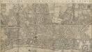
LARGE AND ACCURATE MAP OF THE CITY OF LONDON. Ichnographically describing all the Streets, Lanes, Alleys, Courts, Yards, Churches, Halls and Houses, &Amp;c
1 : 1200 Large map of London printed in 20 sheets featuring title along the top, city arms and dedication to the Lord Mayor, the Aldermen and Sheriffs of the city in cartouche at top left and arms of Sheldon, Lord Mayor at top right and with compass star and dividers at bottom centre. This is the first accurate and detailed map of London, with all the buildings represented in plan rather than as bird's eye views. Ogilby, John and Morgan, William
Insurance Plan of London: sheet 7
This detailed 1889 plan of London is one of a series of six sheets in an atlas originally produced to aid insurance companies in assessing fire risks. The building footprints, their use (commercial, residential, educational, etc.), the number of floors and the height of the building, as well as construction materials (and thus risk of burning) and special fire hazards (chemicals, kilns, ovens) were documented in order to estimate premiums. Names of individual businesses, property lines, and addresses were also often recorded. Together these maps provide a rich historical shapshot of the commercial activity and urban landscape of towns and cities at the time. The British Library holds a comprehensive collection of fire insurance plans produced by the London-based firm Charles E. Goad Ltd. dating back to 1885. These plans were made for most important towns and cities of the British Isles at the scales of 1:480 (1 inch to 40 feet), as well as many foreign towns at 1:600 (1 inch to 50 feet). Chas E Goad Limited Chas E Goad Limited
LONDINIUM
The author of this plan of Roman London, John Britton, was an antiquary and passionate advocate of the preservation of ancient monuments. The plan shows the Roman wall, gates, street plan and road network, with some prominent architectural and geographical features presented pictorially. Britton, John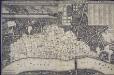
An exact Surveigh of the Streets, Lanes, and Churches contained within the ruines of the City of London, first described in six plats
N. Brooke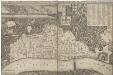
AN EXACT SURVEIGH OF THE STREETS LANES AND CHVRCHES CONTAINED WITHIN THE RVINES OF THE CITY OF LONDON FIRST DESCRIBED IN SIX PLATS
1 : 3620 This map was reduced by John Leake from a large-scale survey on six sheets produced in December 1666 to assess the damage caused by the great fire. No copy of this large scale survey has ever been found. This is the second edition of this map, Updated and issued in 1669 with a dedication to Sir William Turner, The Lord Mayor of London for that year. The map's title appears along the top of the manuscript, With the City arms and dedication at top centre. The key to buildings destroyed in the fire appears in a table at top right, With a compass star at bottom right, Scale bar and imprint at bottom left, And an illustration of the city on fire inset at top left. The location of livery halls destroyed in the fire is indicated by their respective coats of arms. Letters identify individual City wards, With ward boundaries indicated by a pecked line. Buildings outside the city walls, Undamaged by the fire, Are represented three dimensionally. Leake, John
A New and Plaine Mapp of the CITTY of LONDON Shewing the Streets, Lanes, Allies, Courts, Churches Halls and other remarkable places as they are now rebuilt
The title of this map of the City of London appears along the top, with tables of references at top left and right, a compass rose depicted along the river course. St Paul’s Cathedral, the Tower of London, the Roman wall and ships sailing along the Thames are all shown pictorially. The map's publisher, John Overton, had acquired Peter Stent's stock in the mid-17th Century. This stock included many maps by leading Tudor cartographers. His son Henry succeeded him in 1703 and continued the family's publishing business. Overton, John
the Cittie of London 32
This map has been attributed to Augustus Ryther, an engraver who prospered between 1572 and 1592, contributing to Saxton's Atlas of 1579. This plan was produced to satisfy a European market, and contains certain inaccuracies which a native Londoner would not have tolerated. The streets appear very much wider than they were in actuality. Houses are depicted as having large gardens, when these had, in fact, begun to disappear from London two centuries before. Due to the scarcity of maps of London this rather misleading map was printed several times. This is the second edition. The map-seller's imprint has been removed and a large compass rose has been inserted. The Globe playhouse has been omitted on this edition, because of the theatre's destruction in 1644. Hoge Lane, Bedlam and Finsbury Fields have also been added. The map is shows the water conduit near Fleet Bridge, an important link in the water supply line from St Pancras. Ryther, Augustus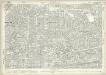
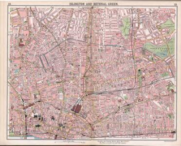
London (1915- Numbered sheets) V.7 (includes: Bethnal Green; Shoreditch; Stepney) - 25 Inch Map
1 : 2500 Topographic maps Ordnance Survey Ordnance Survey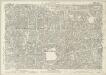
London (Edition of 1894-96) LI (includes: Bethnal Green; Shoreditch; Stepney) - 25 Inch Map
1 : 2500 Topographic maps Ordnance Survey Ordnance Survey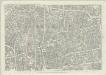
London (First Editions c1850s) XXVII (includes: Bethnal Green; Shoreditch; Stepney) - 25 Inch Map
1 : 2500 Topographic maps Ordnance Survey Ordnance Survey
Insurance Plan of London Vol. xi: sheet 372-1
1 : 480 This detailed 1891 plan of London is one of a series of forty seven sheets in an atlas originally produced to aid insurance companies in assessing fire risks. The building footprints, their use (commercial, residential, educational, etc.), the number of floors and the height of the building, as well as construction materials (and thus risk of burning) and special fire hazards (chemicals, kilns, ovens) were documented in order to estimate premiums. Names of individual businesses, property lines, and addresses were also often recorded. Together these maps provide a rich historical shapshot of the commercial activity and urban landscape of towns and cities at the time. The British Library holds a comprehensive collection of fire insurance plans produced by the London-based firm Charles E. Goad Ltd. dating back to 1885. These plans were made for most important towns and cities of the British Isles at the scales of 1:480 (1 inch to 40 feet), as well as many foreign towns at 1:600 (1 inch to 50 feet). Chas E Goad Limited Chas E Goad Limited
SCHOREDITCH, NORTON FALGATE and CRIPPLEGATE WITHOUT. Taken From y.e last Survey With Corrections 3A
1 : 4800 Plan of Shoreditch in the City of London, published in Strype's first annotated edition of Stow's 'Survey of England'. The plan features title in cartouche at the top of the plate, scale bar and compass at bottom left and key to streets, yards, squares, churches and public buildings in tables at top left and lower right. A dotted line marks the boundary between the parish of St. Leonard Shoreditch and St. Giles Cripple Gate. Hoxton Square, where the development of Shoreditch began in the 1680's is indicated at top right. Blome, Richard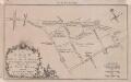
A PLAN OF THE ROADS AND STREETS From Islington to Dog House Bar Delineated to Show A NEW ROAD intended Cross the Fields from Islington to the said Dog House Bar 41 C
1 : 9600 This small plan was published in the London Magazine in 1760.The title appears at bottom left, with scale bars at bottom right and compass star at top right. The intended extension from Angel to Old Street is indicated by a double dotted line, with St. Luke's Church represented pictorially. Built by the Duke of Grafton in 1756 to drive cattle east to Smithfield Market, avoiding Holborn and Oxford Street, this was the capital's first bypass. London Magazine
A Map of the Parish of St. Dunstans Stepney, als. Stebunheath.
A. Churchill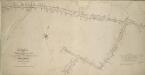
Plan of the Highways held under the Trustees of the OLD STREET TURNPIKE ROADS in the County of Middlesex
Survey of the streets in the Old Street Turnpike Roads Trust, London, from Goswell Street to Hackney Road with title and scale bar at lower left, compass in the centre and key to distances between junctions in table at bottom right. Wickings, W.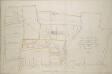
A PLAN of the MANOR of WENLOCK BARN in the Parishes of St. Leonard, Shoreditch & St. Luke, MIDDLESEX
1 : 4680 Drawn plan of the Manor of Wenlock Barn in Shoreditch, London, with title at lower right, scale bar at bottom centre and compass at the top of the sheet. The plan shows the the newly opened City Road and all the turnpikes on nearby roads. Pride, Thomas
London (1915- Numbered sheets) V.11 (includes: Bethnal Green; London; Shoreditch; Stepney) - 25 Inch Map
1 : 2500 Topographic maps Ordnance Survey Ordnance Survey
An Actual Survey of the Parish of St. Leonard in Shoreditch, Middlesex, taken in the Year 1745 by Peter Chassereau. 5
Survey of the roads from Old Street Church to Shoreditch Church with both churches shown pictorially, scale bar at lower right, orientation points marked on margins and key to distances between junctions in table at middle left.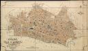
General Plan of the City of London
Haywood, William London
A Plan for Rebuilding the City of London after the Great Fire in 1666; Designed by that Great Architect Sr Chrisr. Wren; & approved by King and Parliament, but unhappily defeated by Faction.
1 : 31680 This is an 18th-Century copy of Sir Christopher Wren's plan for rebuilding London after the great fire destroyed seven-eighths of the city. Wren, at this point an Oxford astronomer with comparatively little architectural experience, was among the first to present a plan to Charles II after the catastrophe. The narrow streets which had helped the fire's progress are replaced on his plan by monumental avenues radiating from piazzas. The influence of the classical buildings and formal street plans which Wren had studied in Paris are a clear influence. He also proposes the construction of a Thameside quay from Bridewell to the Tower, replacing the ramshackle wooden wharfside buildings with warehouses. A vignette of 'Thamesis' (the putative river god) with London burning in the background has been added in the lower margin. Wren's plan was never used. Perhaps due to his eargerness to produce a plan quickly, he was inaccurate in making his ground plan and did not consider contours adequately. Neither king nor parliament were to ever take it seriously despite the title's assertion that it was an approved plan. Wren, Christopher