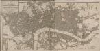
Maps of Hackney

Insurance Plan of London Vol. xi: sheet 383-3
1 : 480 This detailed 1891 plan of London is one of a series of forty seven sheets in an atlas originally produced to aid insurance companies in assessing fire risks. The building footprints, their use (commercial, residential, educational, etc.), the number of floors and the height of the building, as well as construction materials (and thus risk of burning) and special fire hazards (chemicals, kilns, ovens) were documented in order to estimate premiums. Names of individual businesses, property lines, and addresses were also often recorded. Together these maps provide a rich historical shapshot of the commercial activity and urban landscape of towns and cities at the time. The British Library holds a comprehensive collection of fire insurance plans produced by the London-based firm Charles E. Goad Ltd. dating back to 1885. These plans were made for most important towns and cities of the British Isles at the scales of 1:480 (1 inch to 40 feet), as well as many foreign towns at 1:600 (1 inch to 50 feet). Chas E Goad Limited Chas E Goad Limited
Insurance Plan of London Vol. xi: sheet 384-1
1 : 480 This detailed 1891 plan of London is one of a series of forty seven sheets in an atlas originally produced to aid insurance companies in assessing fire risks. The building footprints, their use (commercial, residential, educational, etc.), the number of floors and the height of the building, as well as construction materials (and thus risk of burning) and special fire hazards (chemicals, kilns, ovens) were documented in order to estimate premiums. Names of individual businesses, property lines, and addresses were also often recorded. Together these maps provide a rich historical shapshot of the commercial activity and urban landscape of towns and cities at the time. The British Library holds a comprehensive collection of fire insurance plans produced by the London-based firm Charles E. Goad Ltd. dating back to 1885. These plans were made for most important towns and cities of the British Isles at the scales of 1:480 (1 inch to 40 feet), as well as many foreign towns at 1:600 (1 inch to 50 feet). Chas E Goad Limited Chas E Goad Limited
London VII.38 - OS London Town Plan
1 : 1056 Topographic maps Ordnance Survey Ordnance Survey
Insurance Plan of London Vol. xi: sheet 385-2
1 : 480 This detailed 1891 plan of London is one of a series of forty seven sheets in an atlas originally produced to aid insurance companies in assessing fire risks. The building footprints, their use (commercial, residential, educational, etc.), the number of floors and the height of the building, as well as construction materials (and thus risk of burning) and special fire hazards (chemicals, kilns, ovens) were documented in order to estimate premiums. Names of individual businesses, property lines, and addresses were also often recorded. Together these maps provide a rich historical shapshot of the commercial activity and urban landscape of towns and cities at the time. The British Library holds a comprehensive collection of fire insurance plans produced by the London-based firm Charles E. Goad Ltd. dating back to 1885. These plans were made for most important towns and cities of the British Isles at the scales of 1:480 (1 inch to 40 feet), as well as many foreign towns at 1:600 (1 inch to 50 feet). Chas E Goad Limited Chas E Goad Limited
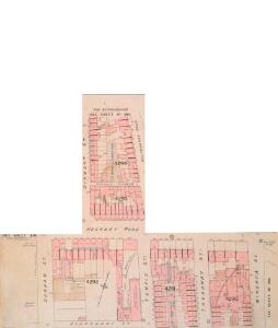
Insurance Plan of London Vol. xi Regent's Canal and Vicinity: Key Plan 1
1 : 4800 This "key plan" indicates coverage of the Goad 1891 series of fire insurance maps of London that were originally produced to aid insurance companies in assessing fire risks. The building footprints, their use (commercial, residential, educational, etc.), the number of floors and the height of the building, as well as construction materials (and thus risk of burning) and special fire hazards (chemicals, kilns, ovens) were documented in order to estimate premiums. Names of individual businesses, property lines, and addresses were also often recorded. Together these maps provide a rich historical shapshot of the commercial activity and urban landscape of towns and cities at the time. The British Library holds a comprehensive collection of fire insurance plans produced by the London-based firm Charles E. Goad Ltd. dating back to 1885. These plans were made for most important towns and cities of the British Isles at the scales of 1:480 (1 inch to 40 feet), as well as many foreign towns at 1:600 (1 inch to 50 feet). Chas E Goad Limited Chas E Goad Limited
London (1915- Numbered sheets) V.7 (includes: Bethnal Green; Shoreditch; Stepney) - 25 Inch Map
1 : 2500 Topographic maps Ordnance Survey Ordnance Survey
London (Edition of 1894-96) LI (includes: Bethnal Green; Shoreditch; Stepney) - 25 Inch Map
1 : 2500 Topographic maps Ordnance Survey Ordnance Survey
London (First Editions c1850s) XXVII (includes: Bethnal Green; Shoreditch; Stepney) - 25 Inch Map
1 : 2500 Topographic maps Ordnance Survey Ordnance Survey
An Actual Survey of the Parish of St. Leonard in Shoreditch, Middlesex, taken in the Year 1745 by Peter Chassereau. 4
1 : 3000 Plan of the parish of St. Leonard in Shoreditch with title in cartouche at top left, compass at top right, scale bar at bottom centre and key to streets, courts, alleys, squares etc. in table at lower right. Each field in the parish is shown with the name of the landlord or tenant and the dimensions. Chassereau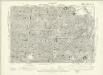
London VII.NE - OS Six-Inch Map
1 : 10560 Topographic maps Ordnance Survey Ordnance Survey
Handy Reference Atlas of London
Edinburgh : John Bartholomew & Co.,
Militärgeographische Angaben über England.
Generalstab des Heeres, Abteilung für Kriegskarten u. Vermessungswesen IV. Mil.-Geo
Insurance Plan of London North & North-East District Vol. E: Key Plan
1 : 21120 This "key plan" indicates coverage of the Goad 1899 series of fire insurance maps of London that were originally produced to aid insurance companies in assessing fire risks. The building footprints, their use (commercial, residential, educational, etc.), the number of floors and the height of the building, as well as construction materials (and thus risk of burning) and special fire hazards (chemicals, kilns, ovens) were documented in order to estimate premiums. Names of individual businesses, property lines, and addresses were also often recorded. Together these maps provide a rich historical shapshot of the commercial activity and urban landscape of towns and cities at the time. The British Library holds a comprehensive collection of fire insurance plans produced by the London-based firm Charles E. Goad Ltd. dating back to 1885. These plans were made for most important towns and cities of the British Isles at the scales of 1:480 (1 inch to 40 feet), as well as many foreign towns at 1:600 (1 inch to 50 feet). Chas E Goad Limited Chas E Goad Limited
Charles Booth's 'Descriptive Map of London Poverty'. Detail showing the City of London and the East End
The East End of London is the hell of poverty. Like one enormous black, motionless giant kraken, the poverty of London lies there in lurking silence and encircles with its mighty tentacles the life and wealth of the City. So wrote J H Mackay in 1891. It was acknowledged that the blame lay with overcrowded housing and with a surplus of labour, which kept wages low for those lucky enough to find work. Statistics for 1888 showed that the East End had 8,465 official paupers - people 'living rough'. According to Charles Booth's survey in 1889, over a third of its inhabitants lived on or below the margin of poverty. His 17-volume survey included this coloured-coded map indicating London's poverty and prosperity street by street. The key to the colours used is as follows: Gold: Upper-middle and Upper classes.Wealthy. Red: Well-to-do. Middle-class. Pink: Fairly comfortable. Good ordinary earning. Purple: Mixed. Some comfortable, others poor. Pale Blue: Poor. 18s. to 21s. a week for moderate family Dark blue: Very poor, casual. Chronic want. Black: Lowest class. Vicious, semi-criminal. Booth, Charles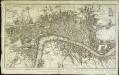
Plan nouveau et correct des villes et fauxbourgs de Londres et Westminster et du bourg de Southwark
1 Plan : Kupferdruck ; 28 x 48 cm Le Rouge Georges Louis le Rouge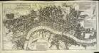
A pocket map of London, Westminster and Southwark
1 Plan : Kupferdruck ; 26 x 51 cm Hoole; Seale printed and sold by H. Overton and J. Hoole at the White Horse without Newgate
LONDON 206
This plan for a survey of London was published in Volume VIII of ‘Encyclopaedia Londinensis' in 1814. The plan's title appears above the plan, with a compass star at the top right. St. Paul's Cathedral and other prominent buildings are shown pictorially, with other places of interest indicated by numbers. Jones, George
A POCKET MAP OF LONDON, WESTMINSTER AND SOUTHWARK With ye New Buildings to ye Year 1739
The map's title appears in English and Dutch in a panel along the top. A descriptive note features below the title, with royal arms at top left, city arms at top right and fares of hackney coaches and water ferries in a panel below the plan. The map shows the new bridge at Westminster and represents prominent buildings and landmark three-dimensionally. De Leth, Hendrick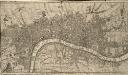
A Correct PLAN of the CITIES of LONDON & WESTMINSTER & BOROUGH of SOUTHWARK, including the BILLS of MORTALITY, with the ADDITIONAL BUILDINGS 118
This map of London was published as supplement to Volume 30 of the 'London Magazine' in 1761. Attributed to John Rocque, the map's title features in a panel below the plan, with the publisher’s imprint along the top. [Rocque, John]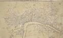
A New PLAN of LONDON WESTMINSTER and SOUTHWARK Engraved for Noorthouck's
This map highlights in red the boundaries of the old London Wall, built by the Romans. By the end of the 17th Century it had become an anachronistic nuisance. The first section (near Bishops Gate) was removed in 1707 and much of the rest was broken down or built over during the 18th Century. Most of the gates were pulled down in 1760/1, wtih Newgate, the last to survive, demolished in 1777. Noorthouck, John
PLATTE GRONDT DER STADT LONDON MET AENWYSINGHE HOE DIE AFGEBRANDT
This map was published in Amsterdam after the great fire of 1666. The title appears along the top of the manuscript, with the key to parish churches (in scrolls) at top left and top right, and dividers at top right. An engraving of the great fire is inset at bottom right, entitled "BRANDENT LONDON". Below the plan, the fire is described in Dutch and French. Wit, Frederick de
PLATTE GRONDT Der Verbrande Stadt LONDON
This map was published in Amsterdam aftermath the great fire of 1666. The title in a banner at top right, flanked by City and Royal arms. The design for rebuilding the City is inset in a panel at top left, with an engraved view of the fire in a banner at bottom centre. Below the plan is a description of the fire in Dutch, French and English with a key to streets and buildings. Doornick, Marcus Willemsz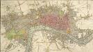
An IMPROVED PLAN of the CITIES of LONDON and WESTMINSTER and BOROUGH of SOUTHWARK, including the NEW BUILDINGS, ROADS &C.
This coloured map shows the built-up area of the City of London as a stippled pattern, with other built-up areas crosshatched. This map is a later edition of Kitching and Parker's 1765 plan, updated to include the new bridge and the approaches at Blackfriars as finally laid out. Designed by Robert Mylne, this third bridge spanning the Thames was built between 1760 and 69. The nine semi-elliptical Portland stone arches were replaced from 1860 to 69 by the present structure of five wrought-iron arches each faced with cast iron, and a granite pier designed by Cubitt and Carr. Kitching, Thomas and Parker, Henry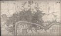
This Actual Survey Of London Westminster Southwark Is Humbly Dedicated To Ye Ld. Mayor & Court of Aldermen
Morden, Robert; Lea, Philip Covens et Mortier
The LONDON DIRECTORY, or a New & Improved PLAN of LONDON, WESTMINSTER, & SOUTHWARK;
This is a reissue of a map first published in 1771 by John Bowles. Bowles' name has been removed, with the imprint of there issuer, Robert Wilkinson, appearing instead. This map highlights the London Wall in red, showing with arrows the direction of water-flow in the Thames. Bowles, John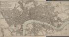
AN ENTIRE NEW PLAN OF THE CITIES OF LONDON AND WESTMINSTER WITH THE BOROUGH OF SOUTHWARK 205
The title and imprint of this folding map of London appear in a table at the top left, facing an advertisement for Mogg's "Survey of the Roads" at the top right. A compass star and scale bar feature at the bottom right. The river, open spaces and city boundaries are distinguished by colour use. A derivative of Cary’s plan of 1790, twenty editions of this map were published between 1803 and 1828. Mogg, Edward
A new PLAN of LONDON, WESTMINSTER and SOUTHWARK 85
This map of London, Westminster and Southwark was published in John Strype's 1720''Survey of the Cities of London and Westminster''. The map's title is at top centre in ornamental cartouche, surrounded by cherubs, fruits and mythological figures. Dedication to Sir George Thorold, Lord Mayor of London appears at top right, facing the city arms at top left. A compass star is depicted at middle right and a scale bar at bottom right. Strype, John
Rowe's map of London, westminster and Southwark, exhibiting the various improvements to the year 1804, detail showing the London and west india Docks
A canal and the two West India docks now cut across the neck of the Isle of Dogs to provide shipping with a shortcut across its marshy peninsular. A wall around its edge holds back the tidal Thames while windmills on the windy west side pump water from the marsh. As industry spreads, wealthy residents are lured away to the fashionable new suburbs rising to the west of London. Turnpikes appear, on the Hackney Road for example: an indication of the growing need for good roads and the money to maintain them. From the tangle of older streets, the line of the proposed new Commercial Road shoots straight across the open fields. Rowe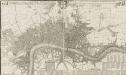
THIS ACTUAL SURVEY OF LONDON, WESTMINSTER & SOUTHWARK IS HUMBLY DEDICATED TO Ye LD MAYOR & COURT OF ALDERMEN
This map is a reissue of a 1690 plan. It features the title in a banner along the top with a compass rose and the city arms. The key to public offices, wards, parishes, halls and companies appear in tables at the bottom and lower right. Prominent buildings shown in elevation. This updated edition includes the Cavendish Square development, which began in 1717. Covens& Mortier was a successful publishing business, including in its output re-issues of general atlases by Jaillot, Delisle, Vichsscher and de Wit, whose stock they had acquired. Covens, Jean & Mortier, Corneille