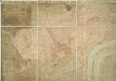
Maps of Westminster

A Plan of St Margarets Parish Westminster showing the improvements of Parliament Street & Bridge Street
This is a map showing the area south of King's Street before the development of Parliament Street. The building marked "A" was pulled down in 1806, with others, to create space around St Margaret's Church and the abbey. The dotted lines that are superimposed on the map show Parliament Street and Bridge Street. John Thomas Smith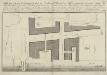
A PLAN of Part of Westminster, from the Hall to the Plantation Office, taken from an actual Survey
1 : 1143 The pricked lines show the boundary of Westminster as it was in 1738. Single pricked lines are houses to be pulled down, while double pricked lines are houses to remain as they are. Shaded blocks are the new houses, with the darker border of these indicating their frontage. Westminster Bridge is annotated ''if it is so approved by Parliament''.
Plan of Westminster Improvements - in Explanation of Report of Select Committee Ho. Co. 31st May 1810
1 : 1920 The printing of this plan was ordered by the House of Commons. It highlights an available premises on Princess Street in orange. Intersecting lines run from Whitehall Chapel to Westminster Abbey, indicating plans to widen the road. This area housed one of the worst tenement complexes (or 'rookeries') in London, something partly attributable to the custom of giving sanctuary to criminals within the abbey precints and the surrounding area. Broad Sanctuary St survives to this day as a testimony to this history. The widening of roads in the area and the construction of Victoria Street from 1845 to 51 resulted in the demolition of much of the rookery. Basire, J.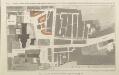
GENERAL OUTLINE OF THE PROPOSED IMPROVEMENTS IN WESTMINSTER ACCORDING TO MEMORIALS OF THE COMMISSIONERS DATED 15TH DEC.R 1813 & 11TH JUNE 1814
1 : 1920 The pink lines on this map show the extent to which King Street and an ''occassional carriageway'' (linking it to St Margaret's Street) are to be widened.& Property on Prince Street and in Old Palace Yard is also marked to be affected by the development.This plans part of a series printed by order of the House of Commons. This area contained one of the worst tenement complexes (or 'rookeries') in London, something partly attributable to the custom of giving sanctuary to criminals within the abbey precincts and the surrounding area. The name Broad Sanctuary Street is a surviving testimony to this history. The widening of roads in the area the construction of Victoria Street from 1845 to 51 resulted in the demolition of much of the rookery. Basire, J.
GROUND PLAN OF PART OF THE CITY OF WESTMINSTER, as it appeared at the CORONATION of KING GEORGE III.1761. (From Rocque''s scare plan of London,)
This is a proof plan details the procession platform, covered in blue cloth, that led from Westminster Hall to the Abbey and the Coronation Theatre within the Abbey. With 60 years as king, George III had the second longest reign in British history. He was third Hanoverian monarch, but the first to be born in England and use English as his first language. His reign was curtailed by bouts of mental instability, blamed by many contemporary commentators on the strain of the American conflict, but more likely caused by the160 hereditary physical disorder porphyria. He was a cultured monarch who donated to the nation a collection of books as the nucleus of a national library, now held in the King's Tower in the British Library. Major, John
A plan of part of the Parish of St Margaret's before the building of Great George Street
Great George Street was built between 1752 and 57 as the westward extension of Bridge Street. The layout of the new street is shown in pencil lines. Smith, John Thomas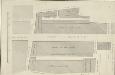
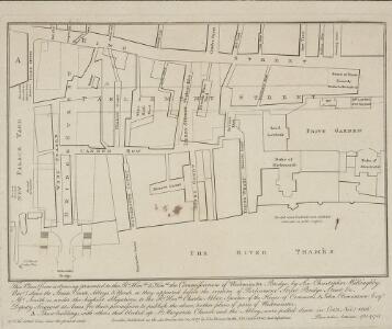
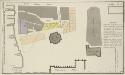
A Plan of the Improvements at Westminster
1 : 800 The building of Westminster Bridge involved replanning and rebuilding around the approaches. New buildings, stables and coach houses marked out on this plan.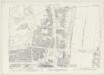
London VII.83 - OS London Town Plan
1 : 1056 Topographic maps Ordnance Survey Ordnance Survey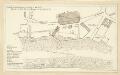
Schetch for the Situation of a Palace at Whitehall the better to Settle that of a Bridge and of a Road to it
Plan of a proposed new palace at Whitehall with key down the left side of the plate.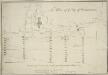
The Plan of ye City of Westminster [showing five locations proposed for the placing of a new bridge]
1 : 3600 Due to the growth of the area in the 18th century, a bridge at Westminster became necessary.This plan shows suggested locations for the building of a bridge. The five locations proposed are: "A", the Horse Ferry on Millbank; "B", College Street or the Slaughter House; "C", the wool stable opposite New Place Yard; "D", Stephen's Alley; "E", Whitehall. There are evident concerns about the Whitehall location being too near the 'elbow' of the river. Cole, B.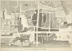
A PLAN of Part of the Ancient City of WESTMINSTER
1 : 1010 In the forty years prior to the publication of this map Sir Christopher Wren had been surveyor of the area around Westminster Abbey and had undertaken restoration work, while his assistant Nicholas Hawksmoor designed the West Towers. The layout of individual piers in Westminster Abbey is shown. C. Fourdrinier & Co,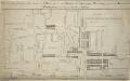
A PLAN of the Lower Parts of the Parishes of ST Margaret and ST JOHN the EVANGELIST, WESTMINSTER, from the HORSE FERRY to WHITEHALL, taken from an ACTUAL SURVEY
1 : 2286 This map shows developments around Westminster Abbey and on the bank of the Thames. Lediard, T.
A MAPP of the Parish of St MARGARETS Westminster taken from the last Survey with Corrections 7 B
This is John Strype's second edition of Stow's survey, published "due to Act of Parliament". This is a reference to the Copyright Act just passed in an effort to stop unauthorised copying of maps. John Stow was a retired sailor who dedicated his retirement to gathering information from records and residents of the Georgian city. The survey extended to include London and Westminster in their entirety, capturing London between Restoration and 18th-century developments. The land on Mill Bank is denoted "Marshy Ground". Renowned for its unhealthy damp atmosphere, it would become the site of the infamous Millbank Penitentiary, and later Tate Britain. Above this a "New Church" sin the process of completion. This would become St John's. Although the survey proved popular, Stow died in poverty at the age of 80,having been granted licence to beg by James I. Stow, John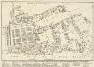
A reduced copy of FISHER'S GROUND PLAN of the ROYAL PALACE of WHITEHALL, taken in the Reign of CHARLES 2d 1680.
This plan of the Royal Palace was published in the early 19th century, but is actually a copy of a plan dating from 1680. A black star shows where King Charles I was beheaded in the January of 1649, after he was convicted of treason by Parliament. Smith, John Thomas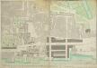
A PLAN of Part of the Ancient City of Westminster
1 : 1028 Thomas Lediard was the agent and surveyor for the Commission for Streets and Waterways.Westminster bridge, the first major bridge to be built across the Thames since the medieval London Bridge, is marked as "New Bridge".The expansion of Westminster in the 18th century necessitated an alternative to the timber Putney Bridge, the only river crossing west of the City.The grey blocks featured on this map are new buildings on the new streets near the approach to Westminster Bridge. Thomas Lediard Esq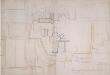
Manuscript] Procession of the Coronation of King George the Second and his Quee
1 : 900 This manuscript plan shows the route of the procession of George II's Coronation, from Westminster Hall to the Abbey. George II's reign was dominated by the Jacobin conflict, and his reign was threatened in 1745 by Charles Edward Stuart, the Young Pretender, who landed in Scotland. The Jacobite threat came to an end when Charles was defeated at the Battle of Culloden in April 1746.The country prospered greatly during George II's reign, with the coal and shipbuilding industries becoming more productive, an overall growth in the population, and the establishment of British control in Madras and Bengal.
Report from Commissioners under 46 Geo III. For Improvements in Westminster.
This plan was ordered by the House of Commons, showing the property that needed to be bought and demolished to make way for the improvements at Westminster Bridge. The watermen who were made largely redundant by this new structure were paid 163;25,000 in compensation. Basire, J.
A Groundplot of part of the Citty of WESTMINSTER [Showing the route of the Procession from the Hall to the Abbey of the Coronation of James II 23rd of April 1685]
1 : 912 The route of the Coronation of King James II in 1685 was lined with His Majesty's Troop of Horses and Regiments of Footguards, represented on this map by groups of circles. At the time there were standing armies of nearly 20,000 men in British kingdoms. The procession moved from Westminster Hall to Westminster Abbey. James converted to Catholicism in 1669, but despite this he succeeded to the throne peacefully at the age of 51. Aiming for religious toleration, James issued the Declaration of Indulgence in 1687. The following year his son, James Stuart, was born to his second wife, the Catholic Mary of Modena, arousing fear that a Roman Catholic dynasty would be established. The Protestant husband of James's elder daughter, William of Orange, invaded on 5 November 1688 and the army and the navy rallied to William, precipitating James' escape to France. James was defeated at the Battle of the Boyne, in Ireland, when he tried to reclaim the throne in 1690. He spent the rest of his life in exile in France, dying there in 1701.
A drawn Plan of the Palace at Whitehall, taken about 1680
MEMORIALS OF THE COMMISSIONERS FOR IMPROVING WESTMINSTER 1811
This plan was ordered by the House of Commons. Different colours are used to denote buildings to be affected by renovations in Westminster. John Nash was a driving force behind many improvements in the Regency period, and his ideas of widening streets continued to influence city planning after his retirement. The narrow streets around Westminster Abbey had long been a dangerous area, with its mixture of criminals, courtiers, pilgrims and the wealthy. This was compounded by the abbey precincts being historically afforded sanctuary from the law. The widening of streets in such areas aimed to disperse the slums and tenements, opening them to light, air and policing. The area covered by this plan is where the modern Victoria Street and Parliament Square would be placed in the 1850s and 60s. Basire, J.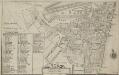
Plan of the Parish of St. Margaret, Westminster From Lea & Morden's Map
1 : 6336 The Abbey, Manchester House and the parish church are shown in elevation. The Decoy in St James' Park is shown. Robert Lea
Sketch of the Procession Usually Observed in the Coronation of our KINGS & QUEENS together with a PLAN pointing out Several new Paths and their Parts Adjacent
A sketch of individuals and their order in the coronation procession is featured at the top of the page.60 years as king, George III's was the second longest reign in British history. He was third Hanoverian monarch, but the first to be born in England and use English as his first language. His reign was curtailed by periodic bouts of mental instability,which many contemporary commentators ascribed to the strain of the American conflict,but was more likely caused by the hereditary physical disorder called porphyria. He was a cultured monarch who donated to the nation a royal collection of books as the nucleus of a national library, now held in the King's Tower;in the British Library.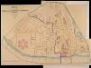
A PLAN of the Streets in the united Parishes of ST. MARGARET & ST. JOHN THE EVANGELIST, Westminster. From a Survey made by I.H. Taylor. No. 22 PARLIAMENT STREET 1828.
Plan of the parishes of St Margaret's, outlined in blue line, and St James', delineated in pink, Westminster. A thin red line shows the boundary of the Tothill Fields District. The large 6-petal structure depicted at lower left is Millbank Penitentiary, built in response to requests for prison reform and finally completed in 1821. Taylor, J. H.
Drawn plan of the Goring Estate] 3
This is a copy by Crace of a plam of the Goring Estate as it was in 1640. The drawing shows the site in Mulberry Garden Fields where Buckingham Palace was built. Crace, Frederick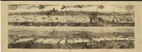
Views of London in 1616 and 1890
1 : 1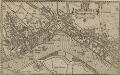
WESTMINSTER
This plan-view of Westminster was published in Norden's 'Speculum Britanniae' in 1593. The title appears at top right below the royal arms, with a compass rose at the foot of the plate. Under different jurisdiction than the City of London, Westminster had developed during the middle ages into a centre of royal administration. Along the Strand are the former residences of the Bishops deposed at the Reformation. By the late 16th Century, these properties were in the hands of the Queen's courtiers, statesmen and other people of influence. Norden, John
A Copy of Part of a Map of London from Newcourt
This is a copy of part of the Faithorne map. It is an example of a bird's-eye (or 'plan') view. Crace often had copies made of maps if he was unable to procure an original.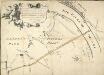
Plan of the Road through Westminster and Tutthill Fields & from St. James's Park Gate by Buckingham House & from Hyde Park Corner to a Bridge that is desired to be made over the Thames 1768 27
This engraved plan shows the road through Tutthill Fields in Westminster leading to the new bridge at Vauxhall.The plan's title features in banner at top left, with compass star at bottom right.The proposed new road stippled and highlighted in colour.
A MAPP of the Parish of St MARGARETS Westminster taken from the last Survey with Corrections 7A
1 : 3692 This is John Strype's first edition of Stow's survey. John Stow was a retired sailor who dedicated his retirement to gathering information from records and residents of the Georgian city.The survey extended to include London and Westminster in their entirety, capturing London between Restoration and 18th-century developments.The land on Mill Bank is denoted "Marshy Ground". Renowned for its unhealthy damp atmosphere,it would become the site of the infamous Millbank Penitentiary, and later Tate Britain. Above this a "New Church" is in the process of completion. This would become St John's. Although the survey proved popular, Stow died in poverty at the age of 80, having been granted licence to beg by James I. Stow, John