Maps of Westminster

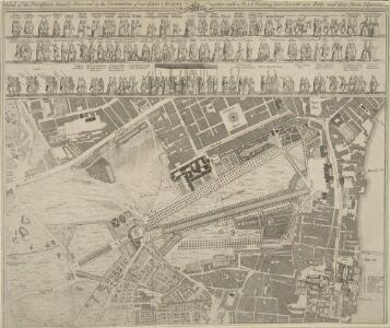
Sketch of the Procession Usually Observed in the Coronation of our KINGS & QUEENS together with a PLAN pointing out Several new Paths and their Parts Adjacent
A sketch of individuals and their order in the coronation procession is featured at the top of the page.60 years as king, George III's was the second longest reign in British history. He was third Hanoverian monarch, but the first to be born in England and use English as his first language. His reign was curtailed by periodic bouts of mental instability,which many contemporary commentators ascribed to the strain of the American conflict,but was more likely caused by the hereditary physical disorder called porphyria. He was a cultured monarch who donated to the nation a royal collection of books as the nucleus of a national library, now held in the King's Tower;in the British Library.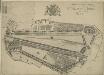
le Palais et Park de St. James. St James Palace and Park
St James's Palace was built by Henry VIII on the site of St James's Hospital, Westminster. It became the principal royal residence in London, after the destruction by fire of Whitehall Palace in 1698. This bird's-eye view shows in detail the palace and grounds, the elevation of the building and the layout of the ornamental gardens. The Admiralty Office is shown on the boundaries of the palace grounds. Kip, J.
London (1915- Numbered sheets) V.13 (includes: City Of Westminster) - 25 Inch Map
1 : 2500 Topographic maps Ordnance Survey Ordnance Survey
London (Edition of 1894-96) LXXV (includes: City Of Westminster) - 25 Inch Map
1 : 2500 Topographic maps Ordnance Survey Ordnance Survey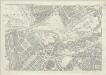
London (First Editions c1850s) XLIII (includes: City Of Westminster) - 25 Inch Map
1 : 2500 Topographic maps Ordnance Survey Ordnance Survey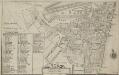
Plan of the Parish of St. Margaret, Westminster From Lea & Morden's Map
1 : 6336 The Abbey, Manchester House and the parish church are shown in elevation. The Decoy in St James' Park is shown. Robert Lea
A MAPP of the Parish of St MARGARETS Westminster taken from the last Survey with Corrections 7A
1 : 3692 This is John Strype's first edition of Stow's survey. John Stow was a retired sailor who dedicated his retirement to gathering information from records and residents of the Georgian city.The survey extended to include London and Westminster in their entirety, capturing London between Restoration and 18th-century developments.The land on Mill Bank is denoted "Marshy Ground". Renowned for its unhealthy damp atmosphere,it would become the site of the infamous Millbank Penitentiary, and later Tate Britain. Above this a "New Church" is in the process of completion. This would become St John's. Although the survey proved popular, Stow died in poverty at the age of 80, having been granted licence to beg by James I. Stow, John
A MAPP of the Parish of St MARGARETS Westminster taken from the last Survey with Corrections 7 B
This is John Strype's second edition of Stow's survey, published "due to Act of Parliament". This is a reference to the Copyright Act just passed in an effort to stop unauthorised copying of maps. John Stow was a retired sailor who dedicated his retirement to gathering information from records and residents of the Georgian city. The survey extended to include London and Westminster in their entirety, capturing London between Restoration and 18th-century developments. The land on Mill Bank is denoted "Marshy Ground". Renowned for its unhealthy damp atmosphere, it would become the site of the infamous Millbank Penitentiary, and later Tate Britain. Above this a "New Church" sin the process of completion. This would become St John's. Although the survey proved popular, Stow died in poverty at the age of 80,having been granted licence to beg by James I. Stow, John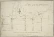
The Plan of ye City of Westminster [showing five locations proposed for the placing of a new bridge]
1 : 3600 Due to the growth of the area in the 18th century, a bridge at Westminster became necessary.This plan shows suggested locations for the building of a bridge. The five locations proposed are: "A", the Horse Ferry on Millbank; "B", College Street or the Slaughter House; "C", the wool stable opposite New Place Yard; "D", Stephen's Alley; "E", Whitehall. There are evident concerns about the Whitehall location being too near the 'elbow' of the river. Cole, B.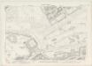
London VII.82 - OS London Town Plan
1 : 1056 Topographic maps Ordnance Survey Ordnance Survey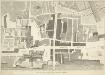
A PLAN of Part of the Ancient City of WESTMINSTER
1 : 1010 In the forty years prior to the publication of this map Sir Christopher Wren had been surveyor of the area around Westminster Abbey and had undertaken restoration work, while his assistant Nicholas Hawksmoor designed the West Towers. The layout of individual piers in Westminster Abbey is shown. C. Fourdrinier & Co,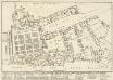
A reduced copy of FISHER'S GROUND PLAN of the ROYAL PALACE of WHITEHALL, taken in the Reign of CHARLES 2d 1680.
This plan of the Royal Palace was published in the early 19th century, but is actually a copy of a plan dating from 1680. A black star shows where King Charles I was beheaded in the January of 1649, after he was convicted of treason by Parliament. Smith, John Thomas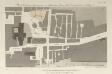
Plan of Westminster Improvements - in Explanation of Report of Select Committee Ho. Co. 31st May 1810
1 : 1920 The printing of this plan was ordered by the House of Commons. It highlights an available premises on Princess Street in orange. Intersecting lines run from Whitehall Chapel to Westminster Abbey, indicating plans to widen the road. This area housed one of the worst tenement complexes (or 'rookeries') in London, something partly attributable to the custom of giving sanctuary to criminals within the abbey precints and the surrounding area. Broad Sanctuary St survives to this day as a testimony to this history. The widening of roads in the area and the construction of Victoria Street from 1845 to 51 resulted in the demolition of much of the rookery. Basire, J.
A PLAN of Part of the Ancient City of Westminster
1 : 1028 Thomas Lediard was the agent and surveyor for the Commission for Streets and Waterways.Westminster bridge, the first major bridge to be built across the Thames since the medieval London Bridge, is marked as "New Bridge".The expansion of Westminster in the 18th century necessitated an alternative to the timber Putney Bridge, the only river crossing west of the City.The grey blocks featured on this map are new buildings on the new streets near the approach to Westminster Bridge. Thomas Lediard Esq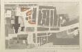
GENERAL OUTLINE OF THE PROPOSED IMPROVEMENTS IN WESTMINSTER ACCORDING TO MEMORIALS OF THE COMMISSIONERS DATED 15TH DEC.R 1813 & 11TH JUNE 1814
1 : 1920 The pink lines on this map show the extent to which King Street and an ''occassional carriageway'' (linking it to St Margaret's Street) are to be widened.& Property on Prince Street and in Old Palace Yard is also marked to be affected by the development.This plans part of a series printed by order of the House of Commons. This area contained one of the worst tenement complexes (or 'rookeries') in London, something partly attributable to the custom of giving sanctuary to criminals within the abbey precincts and the surrounding area. The name Broad Sanctuary Street is a surviving testimony to this history. The widening of roads in the area the construction of Victoria Street from 1845 to 51 resulted in the demolition of much of the rookery. Basire, J.
Plan of Duck Island in St. James's Park of which M. St. Evremond was appointed Governor by Charles 2d.
This is a plan of the Decoy in St James's Park, copied from a drawing made in 1734. A manuscript addition in the top left hand corner refers to a new pond. Smith, John Thomas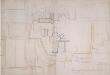
Manuscript] Procession of the Coronation of King George the Second and his Quee
1 : 900 This manuscript plan shows the route of the procession of George II's Coronation, from Westminster Hall to the Abbey. George II's reign was dominated by the Jacobin conflict, and his reign was threatened in 1745 by Charles Edward Stuart, the Young Pretender, who landed in Scotland. The Jacobite threat came to an end when Charles was defeated at the Battle of Culloden in April 1746.The country prospered greatly during George II's reign, with the coal and shipbuilding industries becoming more productive, an overall growth in the population, and the establishment of British control in Madras and Bengal.
Drawn plan of the freehold ground belonging to Sir Charles Sheffield
This is Crace's own copy of an 18th Century survey of the freehold ground belonging to Sir Charles Sheffield, Duke of Buckingham. The drawing depicts the site where Buckingham Palace now stands. Explanatory note at lower left gives terms of lease of various parts of the freehold. Evans, Charles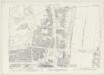
London VII.83 - OS London Town Plan
1 : 1056 Topographic maps Ordnance Survey Ordnance Survey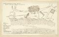
Schetch for the Situation of a Palace at Whitehall the better to Settle that of a Bridge and of a Road to it
Plan of a proposed new palace at Whitehall with key down the left side of the plate.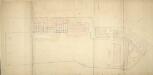
Plan of Carlton House and Garden, Warwick House and Other Houses on the South Side of Pall Mall and Cockspur Street
1 : 480 Built at the beginning of the 18th century for Henry Boyle, Baron Carlton, Carlton House house was purchased in 1732 by Frederick, Prince of Wales.It was in a poor state by the 1780s, and the Prince of Wales commissioned Henry Holland to reconstruct it.Work on the house began in 1783 and continued for 30 years, with neighbouring properties bought and demolished to make way for new wings.This plan shows the extensive walled garden laid out by William Kent along with the ground plots of other houses and stables in Pall Mall and Cockspur Street. Chawner, Thomas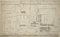
A PLAN of the Lower Parts of the Parishes of ST Margaret and ST JOHN the EVANGELIST, WESTMINSTER, from the HORSE FERRY to WHITEHALL, taken from an ACTUAL SURVEY
1 : 2286 This map shows developments around Westminster Abbey and on the bank of the Thames. Lediard, T.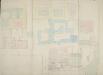
Plan of St. James's Palace, Marlborough House, York House, Bridgewater House and Improvements Intended in St. James's Street and Thatched House Court
1 : 480 The plan shows part of the garden of Marlborough House.The neighbouring St James Palace, Thatched House, Bridgewater House, York House and other properties on St James's Street are shown with their respective lease-expiry dates.Marlborough House was built for Sarah, Duchess of Marlborough, when Queen Anne granted a 50-year lease on the land adjoining St. James's Palace. The house remained in the Marlborough family until 1817 when it was returned to the Crown. Sir Christopher Wren had originally been commissioned to design the house, but the Duchess of Marlborough, unhappy with his work, took over the project herself. Work on the house started in 1709 and was completed by 1711. Chawner, Thomas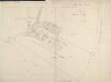
Drawn plan of the estate of Lord Berkley
1 : 768 This plan of Lord Berkley's Estate north of Piccadilly is based on a survey by Haynes in 1767. The plan shows the land from Tyburn Lane to Burlington House, including the Shoulder-of-Mutton Field, Audley Field and Great Brook Field, where the original May Fair was held. The plan also shows the new houses along Curzon Street. Haynes, John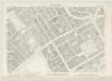
London VII.72 - OS London Town Plan
1 : 1056 Topographic maps Ordnance Survey Ordnance Survey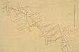
Drawn Plan of King Scholar's Sewer
1 : 1200 This tracing of the King Scholar's sewer in Mayfairis based on a survey carried out by the Commissioners of Sewers. The plan features a scale bar down the right side of the sheet, with boundaries of private properties outlined in red. Open spaces are depicted in green and watercourses in blue.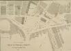
PLAN OF THE CHARING CROSS & STRAND IMPROVEMENTS 1832
Trafalgar Square is indicated in this plan of Charing Cross as King William Square. The National Gallery of Painting and Sculpture is also indicated on the plan. Founded in 1824, the National Gallery was initially housed in a building in Pall Mall until a more suitable one was built on the north side of Trafalgar Square in 1832-38 to a design by William Wilkins. Wyld, James
Report from Commissioners under 46 Geo III. For Improvements in Westminster.
This plan was ordered by the House of Commons, showing the property that needed to be bought and demolished to make way for the improvements at Westminster Bridge. The watermen who were made largely redundant by this new structure were paid 163;25,000 in compensation. Basire, J.
A Groundplot of part of the Citty of WESTMINSTER [Showing the route of the Procession from the Hall to the Abbey of the Coronation of James II 23rd of April 1685]
1 : 912 The route of the Coronation of King James II in 1685 was lined with His Majesty's Troop of Horses and Regiments of Footguards, represented on this map by groups of circles. At the time there were standing armies of nearly 20,000 men in British kingdoms. The procession moved from Westminster Hall to Westminster Abbey. James converted to Catholicism in 1669, but despite this he succeeded to the throne peacefully at the age of 51. Aiming for religious toleration, James issued the Declaration of Indulgence in 1687. The following year his son, James Stuart, was born to his second wife, the Catholic Mary of Modena, arousing fear that a Roman Catholic dynasty would be established. The Protestant husband of James's elder daughter, William of Orange, invaded on 5 November 1688 and the army and the navy rallied to William, precipitating James' escape to France. James was defeated at the Battle of the Boyne, in Ireland, when he tried to reclaim the throne in 1690. He spent the rest of his life in exile in France, dying there in 1701.