Maps of Islington
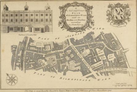
A New and Corrected PLAN of LIMESTREET WARD with its Divisions into Parishes according to a NEW Survey
1 : 3600 This plan was published in William Maitland's 'History of London from its Foundation to the Present Day'. The title features in a cartouche at top centre, with the Arms of John Porter, Alderman of Lime Street, at top right. The scale bar is at bottom right, compass star at bottom left, and an illustrated view of the facade of Leaden Hall market at top left. Maitland's ward plans were largely derived from Strype's plans, with the illustrations copied from West Tow's 'Prospect Views of Ancient Churches' of 1736. Cole, B.
A MAPP OF LIME STREET WARD taken from ye last Survey & Corrected
1 : 3600 This plan was published in Strype's annotated 1720 edition of Stow's "Survey of England". The title features in banner at top left, with compass star at middle left, scale bar at bottom right and key to streets, yards, squares and public places in panel at top right. Leaden Hall market and other prominent buildings are shown pictorially. Blome, Richard
London VII.66 - OS London Town Plan
1 : 1056 Topographic maps Ordnance Survey Ordnance Survey
BROADSTREET WARD Divided into Parishes accoording to a NEW SURVEY CORNHILL WARD Divided into Parishes accoording to a NEW SURVEY.
1 : 1440 This plan was published in William Maitland's 'History of London from its Foundation to the Present Time'. Its title appears on the left side of the plate, along with an illustrated view of the parish church of St Christopher, and the heraldic arms of Francis Cokaine, Alderman of Cornhill ward. Illustrated views of the churches of St Bartholomew and St Bennet Finch appear down the right side of the plate. Maitland's ward plans were largely derived from Strype's, with the illustrations copied from West & Tow's 1736 'Prospect Views of Ancient Churches'. Cole, B.
Insurance Plan of City of London Vol. III: sheet 67
1 : 480 This detailed 1887 plan of London is one of a series of twenty-three sheets in an atlas originally produced to aid insurance companies in assessing fire risks. The building footprints, their use (commercial, residential, educational, etc.), the number of floors and the height of the building, as well as construction materials (and thus risk of burning) and special fire hazards (chemicals, kilns, ovens) were documented in order to estimate premiums. Names of individual businesses, property lines, and addresses were also often recorded. Together these maps provide a rich historical shapshot of the commercial activity and urban landscape of towns and cities at the time. The British Library holds a comprehensive collection of fire insurance plans produced by the London-based firm Charles E. Goad Ltd. dating back to 1885. These plans were made for most important towns and cities of the British Isles at the scales of 1:480 (1 inch to 40 feet), as well as many foreign towns at 1:600 (1 inch to 50 feet). Chas E Goad Limited Chas E Goad Limited
Insurance Plan of City of London Vol. III: sheet 66
1 : 480 This detailed 1887 plan of London is one of a series of twenty-three sheets in an atlas originally produced to aid insurance companies in assessing fire risks. The building footprints, their use (commercial, residential, educational, etc.), the number of floors and the height of the building, as well as construction materials (and thus risk of burning) and special fire hazards (chemicals, kilns, ovens) were documented in order to estimate premiums. Names of individual businesses, property lines, and addresses were also often recorded. Together these maps provide a rich historical shapshot of the commercial activity and urban landscape of towns and cities at the time. The British Library holds a comprehensive collection of fire insurance plans produced by the London-based firm Charles E. Goad Ltd. dating back to 1885. These plans were made for most important towns and cities of the British Isles at the scales of 1:480 (1 inch to 40 feet), as well as many foreign towns at 1:600 (1 inch to 50 feet). Chas E Goad Limited Chas E Goad Limited
Site of Gresham House and Gardens, London
This drawing shows the site of Gresham House and gardens. It is a copy of a section taken from the so-called Copperplate Map of 1555-8 which was copied by and tampered with by Vertue. It shows the site of the old mansion of Sir Thomas Gresham, which he erected in the 16th century in Bishopsgate Street in the City of London. Gresham’s will dictated that the house be used as a college and it was used and known as Gresham College from the year of Gresham’s death in 1579 until 1768. Notes in the margins state that the drawing dates from the time that the house was a college. The plan also shows a section of crenellated London Wall which was built to surround Londinium in the late 2nd century and enclosed 330 acres was 6-9ft wide and 18ft high. Bishops gate is shown here, it takes its name from Eorconweald, Bishop of London, who rebuilt the Roman original in the 7th century. It was demolished in 1760, along with other city gates. Sir Thomas Gresham, a successful merchant, appointed to the King, was instrumental in the creation of the old Royal Exchange.
Insurance Plan of City of London Vol. III: sheet 68
1 : 480 This detailed 1887 plan of London is one of a series of twenty-three sheets in an atlas originally produced to aid insurance companies in assessing fire risks. The building footprints, their use (commercial, residential, educational, etc.), the number of floors and the height of the building, as well as construction materials (and thus risk of burning) and special fire hazards (chemicals, kilns, ovens) were documented in order to estimate premiums. Names of individual businesses, property lines, and addresses were also often recorded. Together these maps provide a rich historical shapshot of the commercial activity and urban landscape of towns and cities at the time. The British Library holds a comprehensive collection of fire insurance plans produced by the London-based firm Charles E. Goad Ltd. dating back to 1885. These plans were made for most important towns and cities of the British Isles at the scales of 1:480 (1 inch to 40 feet), as well as many foreign towns at 1:600 (1 inch to 50 feet). Chas E Goad Limited Chas E Goad Limited
Insurance Plan of City of London Vol. III: sheet 61
1 : 480 This detailed 1887 plan of London is one of a series of twenty-three sheets in an atlas originally produced to aid insurance companies in assessing fire risks. The building footprints, their use (commercial, residential, educational, etc.), the number of floors and the height of the building, as well as construction materials (and thus risk of burning) and special fire hazards (chemicals, kilns, ovens) were documented in order to estimate premiums. Names of individual businesses, property lines, and addresses were also often recorded. Together these maps provide a rich historical shapshot of the commercial activity and urban landscape of towns and cities at the time. The British Library holds a comprehensive collection of fire insurance plans produced by the London-based firm Charles E. Goad Ltd. dating back to 1885. These plans were made for most important towns and cities of the British Isles at the scales of 1:480 (1 inch to 40 feet), as well as many foreign towns at 1:600 (1 inch to 50 feet). Chas E Goad Limited Chas E Goad Limited
Insurance Plan of City of London Vol. III: sheet 60
1 : 480 This detailed 1887 plan of London is one of a series of twenty-three sheets in an atlas originally produced to aid insurance companies in assessing fire risks. The building footprints, their use (commercial, residential, educational, etc.), the number of floors and the height of the building, as well as construction materials (and thus risk of burning) and special fire hazards (chemicals, kilns, ovens) were documented in order to estimate premiums. Names of individual businesses, property lines, and addresses were also often recorded. Together these maps provide a rich historical shapshot of the commercial activity and urban landscape of towns and cities at the time. The British Library holds a comprehensive collection of fire insurance plans produced by the London-based firm Charles E. Goad Ltd. dating back to 1885. These plans were made for most important towns and cities of the British Isles at the scales of 1:480 (1 inch to 40 feet), as well as many foreign towns at 1:600 (1 inch to 50 feet). Chas E Goad Limited Chas E Goad Limited
Insurance Plan of City of London Vol. III: sheet 65
1 : 480 This detailed 1887 plan of London is one of a series of twenty-three sheets in an atlas originally produced to aid insurance companies in assessing fire risks. The building footprints, their use (commercial, residential, educational, etc.), the number of floors and the height of the building, as well as construction materials (and thus risk of burning) and special fire hazards (chemicals, kilns, ovens) were documented in order to estimate premiums. Names of individual businesses, property lines, and addresses were also often recorded. Together these maps provide a rich historical shapshot of the commercial activity and urban landscape of towns and cities at the time. The British Library holds a comprehensive collection of fire insurance plans produced by the London-based firm Charles E. Goad Ltd. dating back to 1885. These plans were made for most important towns and cities of the British Isles at the scales of 1:480 (1 inch to 40 feet), as well as many foreign towns at 1:600 (1 inch to 50 feet). Chas E Goad Limited Chas E Goad Limited
Insurance Plan of City of London Vol. III: sheet 55
1 : 480 This detailed 1887 plan of London is one of a series of twenty-three sheets in an atlas originally produced to aid insurance companies in assessing fire risks. The building footprints, their use (commercial, residential, educational, etc.), the number of floors and the height of the building, as well as construction materials (and thus risk of burning) and special fire hazards (chemicals, kilns, ovens) were documented in order to estimate premiums. Names of individual businesses, property lines, and addresses were also often recorded. Together these maps provide a rich historical shapshot of the commercial activity and urban landscape of towns and cities at the time. The British Library holds a comprehensive collection of fire insurance plans produced by the London-based firm Charles E. Goad Ltd. dating back to 1885. These plans were made for most important towns and cities of the British Isles at the scales of 1:480 (1 inch to 40 feet), as well as many foreign towns at 1:600 (1 inch to 50 feet). Chas E Goad Limited Chas E Goad Limited
Insurance Plan of City of London Vol. III: sheet 59
1 : 480 This detailed 1887 plan of London is one of a series of twenty-three sheets in an atlas originally produced to aid insurance companies in assessing fire risks. The building footprints, their use (commercial, residential, educational, etc.), the number of floors and the height of the building, as well as construction materials (and thus risk of burning) and special fire hazards (chemicals, kilns, ovens) were documented in order to estimate premiums. Names of individual businesses, property lines, and addresses were also often recorded. Together these maps provide a rich historical shapshot of the commercial activity and urban landscape of towns and cities at the time. The British Library holds a comprehensive collection of fire insurance plans produced by the London-based firm Charles E. Goad Ltd. dating back to 1885. These plans were made for most important towns and cities of the British Isles at the scales of 1:480 (1 inch to 40 feet), as well as many foreign towns at 1:600 (1 inch to 50 feet). Chas E Goad Limited Chas E Goad Limited
Insurance Plan of City of London Vol. III: sheet 56
1 : 480 This detailed 1887 plan of London is one of a series of twenty-three sheets in an atlas originally produced to aid insurance companies in assessing fire risks. The building footprints, their use (commercial, residential, educational, etc.), the number of floors and the height of the building, as well as construction materials (and thus risk of burning) and special fire hazards (chemicals, kilns, ovens) were documented in order to estimate premiums. Names of individual businesses, property lines, and addresses were also often recorded. Together these maps provide a rich historical shapshot of the commercial activity and urban landscape of towns and cities at the time. The British Library holds a comprehensive collection of fire insurance plans produced by the London-based firm Charles E. Goad Ltd. dating back to 1885. These plans were made for most important towns and cities of the British Isles at the scales of 1:480 (1 inch to 40 feet), as well as many foreign towns at 1:600 (1 inch to 50 feet). Chas E Goad Limited Chas E Goad Limited
Insurance Plan of City of London Vol. III: sheet 62
1 : 480 This detailed 1887 plan of London is one of a series of twenty-three sheets in an atlas originally produced to aid insurance companies in assessing fire risks. The building footprints, their use (commercial, residential, educational, etc.), the number of floors and the height of the building, as well as construction materials (and thus risk of burning) and special fire hazards (chemicals, kilns, ovens) were documented in order to estimate premiums. Names of individual businesses, property lines, and addresses were also often recorded. Together these maps provide a rich historical shapshot of the commercial activity and urban landscape of towns and cities at the time. The British Library holds a comprehensive collection of fire insurance plans produced by the London-based firm Charles E. Goad Ltd. dating back to 1885. These plans were made for most important towns and cities of the British Isles at the scales of 1:480 (1 inch to 40 feet), as well as many foreign towns at 1:600 (1 inch to 50 feet). Chas E Goad Limited Chas E Goad Limited
A PLAN of all the HOUSES destroyed and damaged by the GREAT FIRE which began in BISHOPSGATE STREET on Thursday Nov.r 7th 1765.
1 : 540 Small plan of the part of Cornhill damaged by the fire of November 1765. The plan features title along the top, scale bar at top left and imprint below the plan. The fire which broke out in the early hours of the morning in Mr. Rutland's peruke making shop in Bishopsgate Street, destroyed forty nine houses damaging a further fifteen. Nicol, William & Jeffrey, Thomas
A PLAN OF THE CHURCH OF ST. PETER UPON CORNHILL, ITS CEMETERY &c.
1 : 72 The title of this plan runs down the right side of the plate, with the scale bar at bottom centre and the names of the parishioners reported on their seats they in the church pews. Erected on the site of an old Roman basilica in AD179, St Peter's church burned down in the great fire of 1666 and was rebuilt by Christopher Wren in the years 1675/81. In the Middle Ages the church housed a large library and a grammar school. Wilkinson, Robert
A Plan of Adams Court on the west side of Broad Street
This plan comes from the archives of the Mercers' Company, a City livery firm that dealt in textiles. The livery companies were guilds of tradesmen that banded together to promote their interests. As the companies were intimately linked with trade they were capable of amassing great wealth and thus to own property.
BISHOPSGATE STREET WARD Taken from the last Survey and Corrected 8A
1 : 3840 This map was published in Strype's first annotated edition of Stow's 'Survey of England'. The plan's title features in ornamental cartouche to the right of the plan, with a compass star at top left and scale bar at bottom right.The keys to streets, yards, halls, courts and private properties appear in tables along both sides of the plate. Blome, Richard
BISHOPSGATE WARD within and without According to a NEW SURVEY.
1 : 3000 This plan was published in William Maitland's 'History of London from its Foundation to the Present Time'. The map's title features in ornamental cartouche near top right, with the arms of dedicatee Mathew Blakiston, the ward's alderman, at top left. An illustrated view of St Ethelburga's church is at bottom left, with Great St Hellen's Church at bottom right. The compass star and scale bar appear at bottom centre. Engraved by Cole, Maitland's ward plans were largely derived from Strype's original plans, with the illustrations copied from West Tow's 'Prospect Views of Ancient Churches' of 1736. Cole, B.
ALDGATE WARD with its Division into Parishes. Taken from the last Survey with Corrections & Alterations 4A
1 : 2400 This map was published in Strype's first annotated edition of Stow's 'Survey of England'. The map's title features in ornamental cartouche at top left, with key to streets, yards, halls, courts and private properties in a table at top centre. The compass star appears at bottom left and scale bar at bottom right. Blome, Richard
A Plan for a Street from MOORGATE to the LONDON BRIDGE.
1 : 6000 This is a plan showing an intended street from Moorgate to London Bridge. Higgins, J.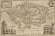
ALDGATE
1 : 2173 This plan was published in William Maitland's 'History of London from Its Foundation to the Present Time'. The plan's title features in cartouche at top left, with the arms of Alderman Robert Scott, to whom the plan is dedicated, at top right. The compass star is included at middle left, with a view of St James' Duke Place at bottom right. The scale bar is at bottom centre with a view of the Church of St Catherine Coleman at bottom right. Engraved by Cole, Maitland's ward plans were largely derived from Strype's plans, with the illustrations copied from West : Tow's 1736 'Prospect Views of Ancient Churches'. Cole, B.
PORTSOKEN WARD with its Divisions into Parishes According to a New SURVEY.
1 : 3360 This plan was published in William Maitland's 'History of London from its Foundations to the Present Day'. The plan's title features in cartouche at bottom left, with the heraldic arms of William Calvert, Alderman of Portsoken, at top right, scale bar at top left and compass star at bottom right. Maitland's ward plans were largely derived from Strype's plans produced for the 'Survey of England'. Cole, B.
BROADSTREET Ward with its divisions into Parishes taken from the last Survey with Corrections and Additions CORNHILL Ward with its divisions into Parishes taken from the last Survey 12A
1 : 1656 This map was published in Strype's first annotated edition of Stow's "Survey of England". The plan's title features in banner at top left and in cartouche at bottom right. The compass star is at bottom left, with scale bar at bottom right and a key to streets, yards, halls, courts and private properties in tables down both sides of the plan.The Royal Exchange and other prominent buildings are shown pictorially. Blome, Richard
BROADSTREET Ward with its divisions into Parishes taken from the last Survey with Corrections and Additions CORNHILL Ward with its divisions into Parishes taken from the last Survey 12B
1 : 1656 This map is taken from Strype's 1755 annotated edition of Stow's 'Survey of England'. The plan's title features in banner at top left and in cartouche at bottom right. The compass star appears at bottom left, with scale bar at bottom right and the keys to streets, yards, halls, courts and private properties in tables down both sides of the plan. The Royal Exchange and other prominent buildings are shown pictorially. First published in 1720, Strype's ward plans were carefully updated for this edition. Blome, Richard
LANGBORNE WARD AND CANDLEWICK WARD with their Divisions into Parishes According to a New SURVEY
1 : 2760 This plan was published in William Maitland's 'History of London from its Foundation to the Present Day'. The plan's title features at top centre, flanked by the heraldic arms of Joseph Kankey, Alderman of Longborn, and Charles Asgill, Alderman of Candlewick. Illustrated views of St Alhallon's church appear at top and bottom left, with a view of St Clement's church at bottom centre and St Mary's church at bottom right. Maitland's ward plans were largely derived from Strype's plans, with the illustrations copied from West & Tow's 1736 'Prospect Views of Ancient Churches'. Cole, B.
PORTSOKEN WARD being part of the Parish of St. Buttolph's Aldgate taken from the last Survey with corrections and Additions. 33A
1 : 3600 This plan was published in Strype's first annotated edition of Stow's 'Survey of England'. The title features in cartouche at the top left, with compass star and scale bar at bottom left. A key to streets, yards, halls and churches appears in panel at lower left. Blome, Richard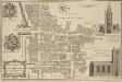
BILLINSGATE WARD AND BRIDGE WARD WITHIN with their Divisions into PARISHES According to a new SURVEY
1 : 1800 This plan was published in William Maitland's 'History of London from its Foundation to the Present Time'. The plan's title features in cartouche at bottom left, with the arms of William Beckford, Alderman of Billinsgate, and William Stephenson, Aldermen of Bridge Ward, down the left side of the plate. The compass star and scale bar are at top centre. At top left and bottom right are illustrated views of the churches of St Mary and St. Botolph. Engraved by Cole, Maitand's ward plans were largely derived from Strype's plans, with the illustrations copied from West Tow's 'Prospect Views of Ancient Churches' of 1736. Cole, B.