Maps of London
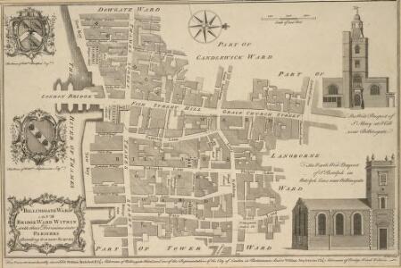
BILLINSGATE WARD AND BRIDGE WARD WITHIN with their Divisions into PARISHES According to a new SURVEY
1 : 1800 This plan was published in William Maitland's 'History of London from its Foundation to the Present Time'. The plan's title features in cartouche at bottom left, with the arms of William Beckford, Alderman of Billinsgate, and William Stephenson, Aldermen of Bridge Ward, down the left side of the plate. The compass star and scale bar are at top centre. At top left and bottom right are illustrated views of the churches of St Mary and St. Botolph. Engraved by Cole, Maitand's ward plans were largely derived from Strype's plans, with the illustrations copied from West Tow's 'Prospect Views of Ancient Churches' of 1736. Cole, B.
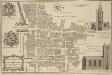
BILLINSGATE and BRIDGE WARD Within with its Division into Parishes taken from the last Survey. 6a
1 : 2400 This map is taken from Strype's first annotated edition of Stow's 'Survey of England'. The map's title appears in ornamental cartouche at top centre, with a key to streets, yards, halls, courts and private properties in a table below the title. The plan also features compass star at bottom left and scale bar at bottom right. Prominent buildings and ships sailing along the Thames are represented pictorially. Blome, Richard
LANGBORNE WARD AND CANDLEWICK WARD with their Divisions into Parishes According to a New SURVEY
1 : 2760 This plan was published in William Maitland's 'History of London from its Foundation to the Present Day'. The plan's title features at top centre, flanked by the heraldic arms of Joseph Kankey, Alderman of Longborn, and Charles Asgill, Alderman of Candlewick. Illustrated views of St Alhallon's church appear at top and bottom left, with a view of St Clement's church at bottom centre and St Mary's church at bottom right. Maitland's ward plans were largely derived from Strype's plans, with the illustrations copied from West & Tow's 1736 'Prospect Views of Ancient Churches'. Cole, B.
Insurance Plan of City of London Vol. III: sheet 50
1 : 480 This detailed 1887 plan of London is one of a series of twenty-three sheets in an atlas originally produced to aid insurance companies in assessing fire risks. The building footprints, their use (commercial, residential, educational, etc.), the number of floors and the height of the building, as well as construction materials (and thus risk of burning) and special fire hazards (chemicals, kilns, ovens) were documented in order to estimate premiums. Names of individual businesses, property lines, and addresses were also often recorded. Together these maps provide a rich historical shapshot of the commercial activity and urban landscape of towns and cities at the time. The British Library holds a comprehensive collection of fire insurance plans produced by the London-based firm Charles E. Goad Ltd. dating back to 1885. These plans were made for most important towns and cities of the British Isles at the scales of 1:480 (1 inch to 40 feet), as well as many foreign towns at 1:600 (1 inch to 50 feet). Chas E Goad Limited Chas E Goad Limited
PLAN Shewing the Site of ST. MICHAEL'S CHURCH, together with the Ancient line of ROADS and BUILDINGS previous to their removal for the Approaches to the NEW LONDON BRIDGE in 1831
1 : 3600 This is a plan of the proposed new streets on the approach to New London Bridge. Also shown is Old London Bridge, which was taken down when the new bridge reached completion. A pecked line shows the boundary of St. Michael's Parish. All the properties in the immediate vicinity of renovations are numbered. Some of these would need to be removed to allow for the building of the new street approaching the bridge. Knight, William
Insurance Plan of City of London Vol. III: sheet 54
1 : 480 This detailed 1887 plan of London is one of a series of twenty-three sheets in an atlas originally produced to aid insurance companies in assessing fire risks. The building footprints, their use (commercial, residential, educational, etc.), the number of floors and the height of the building, as well as construction materials (and thus risk of burning) and special fire hazards (chemicals, kilns, ovens) were documented in order to estimate premiums. Names of individual businesses, property lines, and addresses were also often recorded. Together these maps provide a rich historical shapshot of the commercial activity and urban landscape of towns and cities at the time. The British Library holds a comprehensive collection of fire insurance plans produced by the London-based firm Charles E. Goad Ltd. dating back to 1885. These plans were made for most important towns and cities of the British Isles at the scales of 1:480 (1 inch to 40 feet), as well as many foreign towns at 1:600 (1 inch to 50 feet). Chas E Goad Limited Chas E Goad Limited
Insurance Plan of City of London Vol. III: sheet 60
1 : 480 This detailed 1887 plan of London is one of a series of twenty-three sheets in an atlas originally produced to aid insurance companies in assessing fire risks. The building footprints, their use (commercial, residential, educational, etc.), the number of floors and the height of the building, as well as construction materials (and thus risk of burning) and special fire hazards (chemicals, kilns, ovens) were documented in order to estimate premiums. Names of individual businesses, property lines, and addresses were also often recorded. Together these maps provide a rich historical shapshot of the commercial activity and urban landscape of towns and cities at the time. The British Library holds a comprehensive collection of fire insurance plans produced by the London-based firm Charles E. Goad Ltd. dating back to 1885. These plans were made for most important towns and cities of the British Isles at the scales of 1:480 (1 inch to 40 feet), as well as many foreign towns at 1:600 (1 inch to 50 feet). Chas E Goad Limited Chas E Goad Limited
Insurance Plan of City of London Vol. III: sheet 55
1 : 480 This detailed 1887 plan of London is one of a series of twenty-three sheets in an atlas originally produced to aid insurance companies in assessing fire risks. The building footprints, their use (commercial, residential, educational, etc.), the number of floors and the height of the building, as well as construction materials (and thus risk of burning) and special fire hazards (chemicals, kilns, ovens) were documented in order to estimate premiums. Names of individual businesses, property lines, and addresses were also often recorded. Together these maps provide a rich historical shapshot of the commercial activity and urban landscape of towns and cities at the time. The British Library holds a comprehensive collection of fire insurance plans produced by the London-based firm Charles E. Goad Ltd. dating back to 1885. These plans were made for most important towns and cities of the British Isles at the scales of 1:480 (1 inch to 40 feet), as well as many foreign towns at 1:600 (1 inch to 50 feet). Chas E Goad Limited Chas E Goad Limited
Insurance Plan of City of London Vol. III: sheet 51
1 : 480 This detailed 1887 plan of London is one of a series of twenty-three sheets in an atlas originally produced to aid insurance companies in assessing fire risks. The building footprints, their use (commercial, residential, educational, etc.), the number of floors and the height of the building, as well as construction materials (and thus risk of burning) and special fire hazards (chemicals, kilns, ovens) were documented in order to estimate premiums. Names of individual businesses, property lines, and addresses were also often recorded. Together these maps provide a rich historical shapshot of the commercial activity and urban landscape of towns and cities at the time. The British Library holds a comprehensive collection of fire insurance plans produced by the London-based firm Charles E. Goad Ltd. dating back to 1885. These plans were made for most important towns and cities of the British Isles at the scales of 1:480 (1 inch to 40 feet), as well as many foreign towns at 1:600 (1 inch to 50 feet). Chas E Goad Limited Chas E Goad Limited
Insurance Plan of City of London Vol. I: sheet 7
1 : 480 This detailed 1886 plan of London is one of a series of twenty-five sheets in an atlas originally produced to aid insurance companies in assessing fire risks. The building footprints, their use (commercial, residential, educational, etc.), the number of floors and the height of the building, as well as construction materials (and thus risk of burning) and special fire hazards (chemicals, kilns, ovens) were documented in order to estimate premiums. Names of individual businesses, property lines, and addresses were also often recorded. Together these maps provide a rich historical shapshot of the commercial activity and urban landscape of towns and cities at the time. The British Library holds a comprehensive collection of fire insurance plans produced by the London-based firm Charles E. Goad Ltd. dating back to 1885. These plans were made for most important towns and cities of the British Isles at the scales of 1:480 (1 inch to 40 feet), as well as many foreign towns at 1:600 (1 inch to 50 feet). Chas E Goad Limited Chas E Goad Limited
Insurance Plan of London Vol. 1: sheet 7
1 : 480 This detailed 1904 plan of London is one of a series of twenty-five sheets in an atlas originally produced to aid insurance companies in assessing fire risks. The building footprints, their use (commercial, residential, educational, etc.), the number of floors and the height of the building, as well as construction materials (and thus risk of burning) and special fire hazards (chemicals, kilns, ovens) were documented in order to estimate premiums. Names of individual businesses, property lines, and addresses were also often recorded. Together these maps provide a rich historical shapshot of the commercial activity and urban landscape of towns and cities at the time. The British Library holds a comprehensive collection of fire insurance plans produced by the London-based firm Charles E. Goad Ltd. dating back to 1885. These plans were made for most important towns and cities of the British Isles at the scales of 1:480 (1 inch to 40 feet), as well as many foreign towns at 1:600 (1 inch to 50 feet). Chas E Goad Limited Chas E Goad Limited
Plan of CORNHILL WARD Surveyed October 1833
1 : 3000 This plan's title and imprint appear at bottom left, with scale bar at bottom centre and compass star at bottom left. It shows part of the ground plans of the Royal Exchange, and St Michael's and St Peter's churches. Agnell, Samuel
Insurance Plan of London Vol. 1: sheet 14
1 : 480 This detailed 1904 plan of London is one of a series of twenty-five sheets in an atlas originally produced to aid insurance companies in assessing fire risks. The building footprints, their use (commercial, residential, educational, etc.), the number of floors and the height of the building, as well as construction materials (and thus risk of burning) and special fire hazards (chemicals, kilns, ovens) were documented in order to estimate premiums. Names of individual businesses, property lines, and addresses were also often recorded. Together these maps provide a rich historical shapshot of the commercial activity and urban landscape of towns and cities at the time. The British Library holds a comprehensive collection of fire insurance plans produced by the London-based firm Charles E. Goad Ltd. dating back to 1885. These plans were made for most important towns and cities of the British Isles at the scales of 1:480 (1 inch to 40 feet), as well as many foreign towns at 1:600 (1 inch to 50 feet). Chas E Goad Limited Chas E Goad Limited
Insurance Plan of City of London Vol. I: sheet 14
1 : 480 This detailed 1886 plan of London is one of a series of twenty-five sheets in an atlas originally produced to aid insurance companies in assessing fire risks. The building footprints, their use (commercial, residential, educational, etc.), the number of floors and the height of the building, as well as construction materials (and thus risk of burning) and special fire hazards (chemicals, kilns, ovens) were documented in order to estimate premiums. Names of individual businesses, property lines, and addresses were also often recorded. Together these maps provide a rich historical shapshot of the commercial activity and urban landscape of towns and cities at the time. The British Library holds a comprehensive collection of fire insurance plans produced by the London-based firm Charles E. Goad Ltd. dating back to 1885. These plans were made for most important towns and cities of the British Isles at the scales of 1:480 (1 inch to 40 feet), as well as many foreign towns at 1:600 (1 inch to 50 feet). Chas E Goad Limited Chas E Goad Limited
Insurance Plan of City of London Vol. III: sheet 59
1 : 480 This detailed 1887 plan of London is one of a series of twenty-three sheets in an atlas originally produced to aid insurance companies in assessing fire risks. The building footprints, their use (commercial, residential, educational, etc.), the number of floors and the height of the building, as well as construction materials (and thus risk of burning) and special fire hazards (chemicals, kilns, ovens) were documented in order to estimate premiums. Names of individual businesses, property lines, and addresses were also often recorded. Together these maps provide a rich historical shapshot of the commercial activity and urban landscape of towns and cities at the time. The British Library holds a comprehensive collection of fire insurance plans produced by the London-based firm Charles E. Goad Ltd. dating back to 1885. These plans were made for most important towns and cities of the British Isles at the scales of 1:480 (1 inch to 40 feet), as well as many foreign towns at 1:600 (1 inch to 50 feet). Chas E Goad Limited Chas E Goad Limited
PLAN of the FREEHOLD and LEASEHOLD ESTATES late the Establishment of the GENERAL-POST OFFICE for the Sale in 14 Lots by Mr HOGGART
1 : 216 This is a plan of freehold and leasehold property to be sold at auction. The premises were previously occupied by the Post Office and were sold when the office moved from Lombard Street to St Martin le Grand in 1829. The estate is divided into 14 lots, delineated by pecked lines and colour. A note towards the lower right states that the lease of Lot 4 is held by the Drapers Company. Firth, C. M.
A PLAN OF THE CHURCH OF ST. PETER UPON CORNHILL, ITS CEMETERY &c.
1 : 72 The title of this plan runs down the right side of the plate, with the scale bar at bottom centre and the names of the parishioners reported on their seats they in the church pews. Erected on the site of an old Roman basilica in AD179, St Peter's church burned down in the great fire of 1666 and was rebuilt by Christopher Wren in the years 1675/81. In the Middle Ages the church housed a large library and a grammar school. Wilkinson, Robert
Plan of all the Houses destroyed and damaged by the GREAT FIRE which began in Exchange Alley Cornhill, on Friday March 25, 1748.
1 : 540 This is a plan of part of Cornhill Ward in the City of London damaged by the fire of 1748. The plan features a scale bar at top right with a title in panel below the plan. Beside the title is a note giving an account of the events and a key to distinguishing properties destroyed or damaged by the fire. Jeffrey, Thomas
A PLAN for A STREET Eighty Feet wide, and Fifty Feet deep, on each side, between the ROYAL EXCHANGE AND LONDON BRIDGE
1 : 7200 This is a plan for a new street connecting the Royal Exchange to London Bridge. The different colours used on this plan denote the property of the different wards of Cornhill, Langbourn, Candlewick and Bridge. In the top left corner is a manuscript note about the ''peers'' (supporting piers) of Southwark Bridge. Luffman, John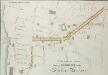
A Plan for a Street from MOORGATE to the LONDON BRIDGE.
1 : 6000 This is a plan showing an intended street from Moorgate to London Bridge. Higgins, J.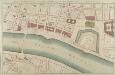
PART of LONDON shewing the IMPROVEMENTS propos'd about LONDON-BRIDGE, the CUSTOM HOUSE, TOWER &c.
The proposed renovations of this new plan are superimposed on the layout of the old. Red lines show new streets in a grid-like formation replacing the older, narrower streets and buildings. A red line across the front of the Tower of London complex possibly indicates a new wall. Gwynn, John
London VII.76 - OS London Town Plan
1 : 1056 Topographic maps Ordnance Survey Ordnance Survey
London VII.66 - OS London Town Plan
1 : 1056 Topographic maps Ordnance Survey Ordnance Survey
WALBROOK WARD and DOWGATE WARD with its Division into Parishes taken from the last Survey 40A
1 : 2040 This plan was published in Strype's first annotated edition of Stowe's 'Survey of England'. Its title features in cartouche at top centre, with compass star at bottom left and scale bar at bottom right. A key to streets, churches and halls appears in a panel down the right side of the plate. Blome, Richard
TOWER STREET WARD with their Division into Parishes according to a New Survey.
1 : 1560 This plan was published in William Maitland's 'History of London from its Foundations to the Present Day'. Its title features in cartouche at top left, with the arms of Thomas Chitty, Alderman of Tower Street ward, at middle left. Inset views of East India House and Westminster Hall appear in panel below the plan. Maitland's ward plans were largely derived from Strype's, with the illustrations copied from West Tow's 1736 'Prospect Views of Ancient Churches'. Cole, B.
TOWER STREET WARD With its Division into Parishes Taken from the last Survey with Corrections. 37A
1 : 1200 This plan was published in Strype's first annotated edition of Stow's 'Survey of England'. Its title features in cartouche at top right, with scale bar at bottom right and compass star at middle left. The key to streets, yards, halls and churches appears in panel down the right side of the plate, with the Navy Office and other prominent buildings shown pictorially. Blome, Richard
WALBROOK WARD AND DOWGATE WARD with their Divisions into Parishes according to a New SURVEY.
1 : 2040 This plan was published in William Maitland's 'History of London from its Foundation to the Present Day'. The title features in cartouche at bottom centre, next to the arms of ward alderman Richard Glynn and the Lord Mayor of London Hingsby Bethall. Thecompass star appears at top centre with views of the parish churches of St Stephen and St Michael down the right side of the plate. Maitland's ward plans were largely derived from Strype's, with the illustrations copied from West Tow's 1736 Prospect Views of Ancient Churches'. Cole, B.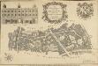
A New and Corrected PLAN of LIMESTREET WARD with its Divisions into Parishes according to a NEW Survey
1 : 3600 This plan was published in William Maitland's 'History of London from its Foundation to the Present Day'. The title features in a cartouche at top centre, with the Arms of John Porter, Alderman of Lime Street, at top right. The scale bar is at bottom right, compass star at bottom left, and an illustrated view of the facade of Leaden Hall market at top left. Maitland's ward plans were largely derived from Strype's plans, with the illustrations copied from West Tow's 'Prospect Views of Ancient Churches' of 1736. Cole, B.
Insurance Plan of City of London Vol. III: sheet 56
1 : 480 This detailed 1887 plan of London is one of a series of twenty-three sheets in an atlas originally produced to aid insurance companies in assessing fire risks. The building footprints, their use (commercial, residential, educational, etc.), the number of floors and the height of the building, as well as construction materials (and thus risk of burning) and special fire hazards (chemicals, kilns, ovens) were documented in order to estimate premiums. Names of individual businesses, property lines, and addresses were also often recorded. Together these maps provide a rich historical shapshot of the commercial activity and urban landscape of towns and cities at the time. The British Library holds a comprehensive collection of fire insurance plans produced by the London-based firm Charles E. Goad Ltd. dating back to 1885. These plans were made for most important towns and cities of the British Isles at the scales of 1:480 (1 inch to 40 feet), as well as many foreign towns at 1:600 (1 inch to 50 feet). Chas E Goad Limited Chas E Goad Limited