Maps of Islington

A plan of the property belonging to the Duke of Norfolk in the Strand
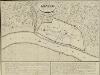
This plan shows Arundel House and its garden as they appeared in 1720. Arundel House had been used as a garrison since 1646, but was returned to Henry, the sixth Duke of Norfolk, at the Reformation.
Insurance Plan of London Vol. VIII: sheet 186
1 : 480 This detailed 1888 plan of London is one of a series of twenty-six sheets in an atlas originally produced to aid insurance companies in assessing fire risks. The building footprints, their use (commercial, residential, educational, etc.), the number of floors and the height of the building, as well as construction materials (and thus risk of burning) and special fire hazards (chemicals, kilns, ovens) were documented in order to estimate premiums. Names of individual businesses, property lines, and addresses were also often recorded. Together these maps provide a rich historical shapshot of the commercial activity and urban landscape of towns and cities at the time. The British Library holds a comprehensive collection of fire insurance plans produced by the London-based firm Charles E. Goad Ltd. dating back to 1885. These plans were made for most important towns and cities of the British Isles at the scales of 1:480 (1 inch to 40 feet), as well as many foreign towns at 1:600 (1 inch to 50 feet). Chas E Goad Limited Chas E Goad Limited
Insurance Plan of City of London Vol. II: sheet 30-2
1 : 480 This detailed 1886 plan of London is one of a series of twenty sheets in an atlas originally produced to aid insurance companies in assessing fire risks. The building footprints, their use (commercial, residential, educational, etc.), the number of floors and the height of the building, as well as construction materials (and thus risk of burning) and special fire hazards (chemicals, kilns, ovens) were documented in order to estimate premiums. Names of individual businesses, property lines, and addresses were also often recorded. Together these maps provide a rich historical shapshot of the commercial activity and urban landscape of towns and cities at the time. The British Library holds a comprehensive collection of fire insurance plans produced by the London-based firm Charles E. Goad Ltd. dating back to 1885. These plans were made for most important towns and cities of the British Isles at the scales of 1:480 (1 inch to 40 feet), as well as many foreign towns at 1:600 (1 inch to 50 feet). Chas E Goad Limited Chas E Goad Limited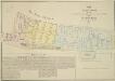
MAP OF THE Manor of the Savoy AND OF THE LIBERTY OF THE DUCHY OF LANCASTER CALLED The Savoy Liberty, In the County of Middlesex. 1830
1 : 1128 The Savoy Liberty is divided into four wards which are delineated by different pastle shades, an explanation of which appears in the table. St Mary-le-Strand and the Site of the Lyceum Theatre, now in ruins, are shown, as is the ancient site of Burliegh House. Madeley, G. E.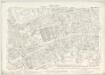
London VII.64 - OS London Town Plan
1 : 1056 Topographic maps Ordnance Survey Ordnance Survey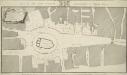
PLAN OF THE CITYS INTENDED IMPROVEMENT AT TEMPLE BAR.
1 : 336 The church of St Mary le Strand is shown. Buildings outlined in red and numbered are those to be purchased and then destroyed to widen the roads and ease traffic. The renovation was completed in 1878. Metcalf, R.
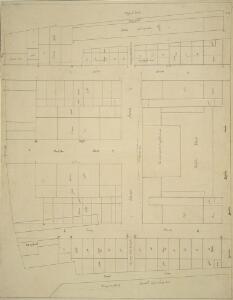
Insurance Plan of London Vol. VIII: sheet 185
1 : 480 This detailed 1888 plan of London is one of a series of twenty-six sheets in an atlas originally produced to aid insurance companies in assessing fire risks. The building footprints, their use (commercial, residential, educational, etc.), the number of floors and the height of the building, as well as construction materials (and thus risk of burning) and special fire hazards (chemicals, kilns, ovens) were documented in order to estimate premiums. Names of individual businesses, property lines, and addresses were also often recorded. Together these maps provide a rich historical shapshot of the commercial activity and urban landscape of towns and cities at the time. The British Library holds a comprehensive collection of fire insurance plans produced by the London-based firm Charles E. Goad Ltd. dating back to 1885. These plans were made for most important towns and cities of the British Isles at the scales of 1:480 (1 inch to 40 feet), as well as many foreign towns at 1:600 (1 inch to 50 feet). Chas E Goad Limited Chas E Goad Limited
Insurance Plan of City of London Vol. II: sheet 30-1
1 : 480 This detailed 1886 plan of London is one of a series of twenty sheets in an atlas originally produced to aid insurance companies in assessing fire risks. The building footprints, their use (commercial, residential, educational, etc.), the number of floors and the height of the building, as well as construction materials (and thus risk of burning) and special fire hazards (chemicals, kilns, ovens) were documented in order to estimate premiums. Names of individual businesses, property lines, and addresses were also often recorded. Together these maps provide a rich historical shapshot of the commercial activity and urban landscape of towns and cities at the time. The British Library holds a comprehensive collection of fire insurance plans produced by the London-based firm Charles E. Goad Ltd. dating back to 1885. These plans were made for most important towns and cities of the British Isles at the scales of 1:480 (1 inch to 40 feet), as well as many foreign towns at 1:600 (1 inch to 50 feet). Chas E Goad Limited Chas E Goad Limited
Plan of the improvements in the Strand near St Clements Church
1 : 336 Plan showing the area around St Clement's Church after the improvements in the Strand.
A Mapp of the Parishes of {ST.CLEMENTS DANES, ST. MARY SAVOY; with the Rolls Liberty and Lincolns Inn. taken From the last Survey with Corrections and Additions 50
1 : 2616 This is the second edition of Blome's map. His name was removed from the cartouche because Strype had taken over as editor of the project. The map shows in elevation the Savoy, Somerset House and gardens, Exeter Exchange and temple, and Lincoln's Inn. The church, St Mary-le-Strand, opposite Somerset House was absent from the earlier edition. It is shown here in plan, but is unnamed and not referred to in the numerical key. Blome, Richard
Plan of Kingsway, From Report of the Royal Commission on cross-river traffic in London, Plate XVIII

Legal London
Hoffman, G.
Insurance Plan of London Vol. VIII: Key Plan
1 : 480 This "key plan" indicates coverage of the Goad 1888 series of fire insurance maps of London that were originally produced to aid insurance companies in assessing fire risks. The building footprints, their use (commercial, residential, educational, etc.), the number of floors and the height of the building, as well as construction materials (and thus risk of burning) and special fire hazards (chemicals, kilns, ovens) were documented in order to estimate premiums. Names of individual businesses, property lines, and addresses were also often recorded. Together these maps provide a rich historical shapshot of the commercial activity and urban landscape of towns and cities at the time. The British Library holds a comprehensive collection of fire insurance plans produced by the London-based firm Charles E. Goad Ltd. dating back to 1885. These plans were made for most important towns and cities of the British Isles at the scales of 1:480 (1 inch to 40 feet), as well as many foreign towns at 1:600 (1 inch to 50 feet). Chas E Goad Limited Chas E Goad Limited
London (1915- Numbered sheets) V.10 (includes: City Of Westminster; Finsbury; Holborn; Inner Temple; Lambeth St Mary; London; Southwark) - 25 Inch Map
1 : 2500 Topographic maps Ordnance Survey Ordnance Survey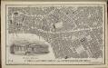
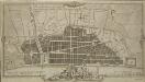
Collins' Illustrated Atlas of London with 7000 references, in 36 plates of the principal routes between St. Paul's and the suburbs, from a survey made expressly for this work, by R. Jarman
Views of London in 1616 and 1890
1 : 1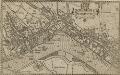
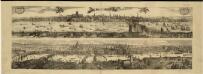
WESTMINSTER
This plan-view of Westminster was published in Norden's 'Speculum Britanniae' in 1593. The title appears at top right below the royal arms, with a compass rose at the foot of the plate. Under different jurisdiction than the City of London, Westminster had developed during the middle ages into a centre of royal administration. Along the Strand are the former residences of the Bishops deposed at the Reformation. By the late 16th Century, these properties were in the hands of the Queen's courtiers, statesmen and other people of influence. Norden, John
Insurance Plan of London: sheet 6
This detailed 1889 plan of London is one of a series of six sheets in an atlas originally produced to aid insurance companies in assessing fire risks. The building footprints, their use (commercial, residential, educational, etc.), the number of floors and the height of the building, as well as construction materials (and thus risk of burning) and special fire hazards (chemicals, kilns, ovens) were documented in order to estimate premiums. Names of individual businesses, property lines, and addresses were also often recorded. Together these maps provide a rich historical shapshot of the commercial activity and urban landscape of towns and cities at the time. The British Library holds a comprehensive collection of fire insurance plans produced by the London-based firm Charles E. Goad Ltd. dating back to 1885. These plans were made for most important towns and cities of the British Isles at the scales of 1:480 (1 inch to 40 feet), as well as many foreign towns at 1:600 (1 inch to 50 feet). Chas E Goad Limited Chas E Goad Limited
A Map of the Surrey Side the Thames from Westminster Bridge to the Borough. With a Plan for laying out the Roads, to BLACK FRYARS BRIDGE
The title of this map of St. George's Fields, Southwark, appears below the plan with key at bottom right. Alternative plans for laying out Blackfriars Road are indicated by double-dotted and pricked lines. The mile-long road was finally finished in the last quarter of the 18th Century.
LABYRINTHUS LONDINENSIS or THE EQUESTRIAN PERPLEXED
The author of this small plan of London invites his readers to find their way around the city, from the Strand to St. Paul's, avoiding the many roads closed for repair. The plan's title appears at the top, with the royal Arms at the top left, the city arms at the top right, the arms of Bridge House at the bottom right and the arms of Westminster at the bottom left. A note explains the rules of the puzzle in the panel below the plan. Ingrey, Charles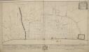
A "plan of the city of London after the great fire in the year of our Lord 1666; with the modell of the new city according to the design and proposal of Sir Christopher Wren, Knt., etc., for rebuilding thereof;"
A Plan for Rebuilding the City of London after the Great Fire in 1666; Designed by that Great Architect Sr Chrisr. Wren; & approved by King and Parliament, but unhappily defeated by Faction.
1 : 31680 This is an 18th-Century copy of Sir Christopher Wren's plan for rebuilding London after the great fire destroyed seven-eighths of the city. Wren, at this point an Oxford astronomer with comparatively little architectural experience, was among the first to present a plan to Charles II after the catastrophe. The narrow streets which had helped the fire's progress are replaced on his plan by monumental avenues radiating from piazzas. The influence of the classical buildings and formal street plans which Wren had studied in Paris are a clear influence. He also proposes the construction of a Thameside quay from Bridewell to the Tower, replacing the ramshackle wooden wharfside buildings with warehouses. A vignette of 'Thamesis' (the putative river god) with London burning in the background has been added in the lower margin. Wren's plan was never used. Perhaps due to his eargerness to produce a plan quickly, he was inaccurate in making his ground plan and did not consider contours adequately. Neither king nor parliament were to ever take it seriously despite the title's assertion that it was an approved plan. Wren, Christopher
A Copy of Part of a Map of London from Newcourt
This is a copy of part of the Faithorne map. It is an example of a bird's-eye (or 'plan') view. Crace often had copies made of maps if he was unable to procure an original.
A MAP or GROVNDPLOT OF THE CITTY OF LONDON, WITH THE SVBVRBES THEREOF
1 : 9386 Engraved map of London with title along the top, reference table with key to the city's landmarks and churches at top right and bottom left respectively and with compass star and scale bar at bottom right. The map shows the extent of the damage to the city caused by the great fire of 1666; the barren city wards contrasting with birds eye views of surviving buildings just outside the city. This small map was probably the basis for the many variations on the theme of the "London Verbrandt" which were published in Amsterdam by Venckel and De Wit in the aftermath of the fire. The fire broke out at a bakers shop on Pudding Lane near London Bridge on the 2nd of September 1666. The fire destroyed nearly the whole city 13.000 buildings circa and though the casualties were few only eight people died because of the fire thousands were made homeless. Hollar, Wenceslaus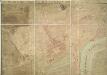
A PLAN OF HIS MAJESTY'S BAYLIWICK OF ST. JAMES IN THE COUNTY OF MIDDLESEX
1 : 2400 This drawn survey of the West of London extends from Knightsbridge to Temple Bar and from Marylebone Gardens to Buckingham Palace. Buildings are indicated in red, open spaces and park land in green and watercourses in blue. Symbols are used to distinguish land use. Gough, William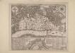
An Exact Map representing the conditions of the late famous and flourishing City of London
1 : 6336 Engraved map of London and suburbs (including Lincoln Inn Fields, Finsbury Fields, Smith Fields and Bankside in Southwark) in which barren city wards contrast with birds eye views of surviving buildings outside the city, showing at a glancethe extent of the damage to the city caused by the great fire of 1666. The map features title along the top, with arms of the city and compass rose depicted at top left and right respectively. Also by Pricke is the inset map in the panel at the foot of the plate. Entitled "A map of the Whole City of London and Westminster with the Suburbs, Whearein May Be Judged What Proportion is Burnt and What Remains Standing", this smaller scale map (two inches to the mile) is flanked by reference tables with key to churches and halls of the London Livery companies. Pricke, Robert
A guide for Cuntrey men In the famous Cittey of LONDON by the helpe of wich plot they shall be able to know how farr it is to any Street...
This 1593 map is the direct forbear of the modern London A-Z. This copy comes from the 1653 edition of John Norden's 'Speculum Britainiae' (literally: 'Mirror of Britain'), re-issued after Norden's death and sold by Peter Stent of Newgate. Around the edges of the map appear the coats of arms of the twelve most influential and wealthy city guilds: the 'Great Liveries'. Guild members became known as liverymen because they wore a distinctive livery or uniform. At top right is the Merchant Tailors company, which made tents and padded tunics during the middle ages. This is reflected by the tent motif on the coat of arms. Norden, John
the Cittie of London 32
This map has been attributed to Augustus Ryther, an engraver who prospered between 1572 and 1592, contributing to Saxton's Atlas of 1579. This plan was produced to satisfy a European market, and contains certain inaccuracies which a native Londoner would not have tolerated. The streets appear very much wider than they were in actuality. Houses are depicted as having large gardens, when these had, in fact, begun to disappear from London two centuries before. Due to the scarcity of maps of London this rather misleading map was printed several times. This is the second edition. The map-seller's imprint has been removed and a large compass rose has been inserted. The Globe playhouse has been omitted on this edition, because of the theatre's destruction in 1644. Hoge Lane, Bedlam and Finsbury Fields have also been added. The map is shows the water conduit near Fleet Bridge, an important link in the water supply line from St Pancras. Ryther, Augustus
LONDINIUM Augusta
1 : 11019 The title of this engraved map of Roman London appears along the top, with compass rose at top right.The arms of the Count of Pembroke, to whom the map is dedicated, are depicted at bottom right. Published in 'Itinerarium Curiosum' by William Stukeley, an antiquarian with a scholarly interest in sacred history, the plan shows the Roman street plan and road network, with illustrated views of the city wall and other prominent architectural and geographical features. Stukeley, Dr. William