Maps of Islington
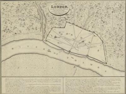
The City of LONDON in the Time of the Saxons (about the Year 1000) compiled from the most authentic DOCUMENTS
Map of London in the reign of the Saxon King Ethelred II, with the history of Roman and Saxon London written in a panel below the plan. The map shows the Roman wall still standing, but the street plan suggests that, compared to the Roman period, the built-up area occupied a much smaller part of the walled city and that the population was in rapid decline. Wallis
LONDON and WESTMINSTER in the Reign of QUEEN ELIZABETH Anno Dom. 1563
This is a retrospective map of Elizabethan London, giving us an idea of how people in the late 18th Century viewed the Elizabethan capital. The present-day Covent Garden is an area of fields named "Convent Garden”, indicating that the area belonged to the Abbey of St Peter's at Westminster before the dissolution of monasteries in the reign of Henry VIII. The location of Tower Bridge is marked, although the actual bridge was not planned until 1879. This indicates that Londoners were thinking about bridging the river at this point one hundred years before the decisive plan to do so. Wallis, J.
LONDINIUM Augusta
1 : 11019 The title of this engraved map of Roman London appears along the top, with compass rose at top right.The arms of the Count of Pembroke, to whom the map is dedicated, are depicted at bottom right. Published in 'Itinerarium Curiosum' by William Stukeley, an antiquarian with a scholarly interest in sacred history, the plan shows the Roman street plan and road network, with illustrated views of the city wall and other prominent architectural and geographical features. Stukeley, Dr. William
Englands glory, or, the glory of England being a new mapp of the city of London : shewing the remarkable streets, lanes, alleyes, churches, halls courts, and other places as they are now rebuilt, the which will therefore be a guide to strangers, and such as are not well acquainted herein to direct them from place to place : diverse faults y[t] are in y[e] former are in this amended, allsoe the severall figures y[t] stand up and downe in the mapp are explained in y[e] 2 tables at y[e] upper corners hereof.
Walton, Robert, 1618-1688 Robert Walton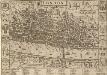
LONDON 21
This map was published in Norden's 1593 'Speculum Britanniae. The first parte. An historical and chronographical description of Middlesex'. The map is flanked by the arms of the twelve great livery companies and features title at the top with royal and city arms. The scale bar is at top right and a key to inns, churches, halls and other prominent places feature in a panel below the plan. The map was intended for countrymen visiting the city and was reissued in 1623 and 1653 with enlarged tables of reference. Norden, John
LONDON and WESTMINSTER in the Reign of QUEEN ELIZABETH, Anno Dom. 1563 25
This retrospective map of Elizabethan London was produced in the 1820s. It provides us with an idea of how people in the19th century viewed the Elizabethan city. The location of Tower Bridge is indicated on this map, even though plans for the actual bridge were not made until 1879. Neele, George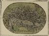
LONDON 20
A miniature map of London and Westminster with title at the foot of the plate and areas outside the built-up area coloured green.
the Cittie of London 31
This map has been attributed to Augustus Ryther, an engraver who prospered between 1572 and 1592, contributing to Saxton's Atlas of 1579. This plan was produced to satisfy a European market, and contains certain inaccuracies which a native Londoner would not have tolerated. The streets appear very much wider than they were in actuality. Houses are depicted as having large gardens, when these had, in fact, begun to disappear from London two centuries before. The map details the gap at the north end of London Bridge, caused by a fire in 1632. Ryther, Augustus
the Cittie of London 32
This map has been attributed to Augustus Ryther, an engraver who prospered between 1572 and 1592, contributing to Saxton's Atlas of 1579. This plan was produced to satisfy a European market, and contains certain inaccuracies which a native Londoner would not have tolerated. The streets appear very much wider than they were in actuality. Houses are depicted as having large gardens, when these had, in fact, begun to disappear from London two centuries before. Due to the scarcity of maps of London this rather misleading map was printed several times. This is the second edition. The map-seller's imprint has been removed and a large compass rose has been inserted. The Globe playhouse has been omitted on this edition, because of the theatre's destruction in 1644. Hoge Lane, Bedlam and Finsbury Fields have also been added. The map is shows the water conduit near Fleet Bridge, an important link in the water supply line from St Pancras. Ryther, Augustus
LONDON FERACISSIMI ANGLIAE REGNI METROPOLIS
The title of this map of London appears at the top of the plate, flanked by Tudor and city arms. A note on the history of London features at bottom left and on the Steelyard at bottom right. Illustrated figures of merchants appear at bottom centre. Published in 'Civitates Orbis Terrarum', the map is similar in detail to the 'Copperplate Map', the earliest printed map of London of which no complete copy survives. Merchant ships, cranes, mills, bull and bear baiting pits, the large tennis courts at Westminster and the stags in St. James’s are examples of London business and leisure activities. Walled gardens, elegant churches and livery halls testify to the high quality of life enjoyed by its citizens. Braun, Georg & Hogenberg, Frans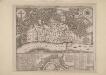
An Exact Map representing the conditions of the late famous and flourishing City of London
1 : 6336 Engraved map of London and suburbs (including Lincoln Inn Fields, Finsbury Fields, Smith Fields and Bankside in Southwark) in which barren city wards contrast with birds eye views of surviving buildings outside the city, showing at a glancethe extent of the damage to the city caused by the great fire of 1666. The map features title along the top, with arms of the city and compass rose depicted at top left and right respectively. Also by Pricke is the inset map in the panel at the foot of the plate. Entitled "A map of the Whole City of London and Westminster with the Suburbs, Whearein May Be Judged What Proportion is Burnt and What Remains Standing", this smaller scale map (two inches to the mile) is flanked by reference tables with key to churches and halls of the London Livery companies. Pricke, Robert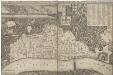
AN EXACT SURVEIGH OF THE STREETS LANES AND CHVRCHES CONTAINED WITHIN THE RVINES OF THE CITY OF LONDON FIRST DESCRIBED IN SIX PLATS
1 : 3620 This map was reduced by John Leake from a large-scale survey on six sheets produced in December 1666 to assess the damage caused by the great fire. No copy of this large scale survey has ever been found. This is the second edition of this map, Updated and issued in 1669 with a dedication to Sir William Turner, The Lord Mayor of London for that year. The map's title appears along the top of the manuscript, With the City arms and dedication at top centre. The key to buildings destroyed in the fire appears in a table at top right, With a compass star at bottom right, Scale bar and imprint at bottom left, And an illustration of the city on fire inset at top left. The location of livery halls destroyed in the fire is indicated by their respective coats of arms. Letters identify individual City wards, With ward boundaries indicated by a pecked line. Buildings outside the city walls, Undamaged by the fire, Are represented three dimensionally. Leake, John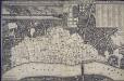
An exact Surveigh of the Streets, Lanes, and Churches contained within the ruines of the City of London, first described in six plats
N. Brooke
A guide for Cuntrey men In the famous Cittey of LONDON by the helpe of wich plot they shall be able to know how farr it is to any Street...
This 1593 map is the direct forbear of the modern London A-Z. This copy comes from the 1653 edition of John Norden's 'Speculum Britainiae' (literally: 'Mirror of Britain'), re-issued after Norden's death and sold by Peter Stent of Newgate. Around the edges of the map appear the coats of arms of the twelve most influential and wealthy city guilds: the 'Great Liveries'. Guild members became known as liverymen because they wore a distinctive livery or uniform. At top right is the Merchant Tailors company, which made tents and padded tunics during the middle ages. This is reflected by the tent motif on the coat of arms. Norden, John
A MAP or GROVNDPLOT OF THE CITTY OF LONDON, WITH THE SVBVRBES THEREOF
1 : 9386 Engraved map of London with title along the top, reference table with key to the city's landmarks and churches at top right and bottom left respectively and with compass star and scale bar at bottom right. The map shows the extent of the damage to the city caused by the great fire of 1666; the barren city wards contrasting with birds eye views of surviving buildings just outside the city. This small map was probably the basis for the many variations on the theme of the "London Verbrandt" which were published in Amsterdam by Venckel and De Wit in the aftermath of the fire. The fire broke out at a bakers shop on Pudding Lane near London Bridge on the 2nd of September 1666. The fire destroyed nearly the whole city 13.000 buildings circa and though the casualties were few only eight people died because of the fire thousands were made homeless. Hollar, Wenceslaus
LONDINIUM
The author of this plan of Roman London, John Britton, was an antiquary and passionate advocate of the preservation of ancient monuments. The plan shows the Roman wall, gates, street plan and road network, with some prominent architectural and geographical features presented pictorially. Britton, John
A New and Plaine Mapp of the CITTY of LONDON Shewing the Streets, Lanes, Allies, Courts, Churches Halls and other remarkable places as they are now rebuilt
The title of this map of the City of London appears along the top, with tables of references at top left and right, a compass rose depicted along the river course. St Paul’s Cathedral, the Tower of London, the Roman wall and ships sailing along the Thames are all shown pictorially. The map's publisher, John Overton, had acquired Peter Stent's stock in the mid-17th Century. This stock included many maps by leading Tudor cartographers. His son Henry succeeded him in 1703 and continued the family's publishing business. Overton, John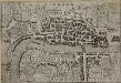
LONDRA
This small Italian etching is one of the earliest surviving maps of the city of London. It appeared in a book by Francesco Velagio entitled 'Raccolta di le piu` illustri et famose citta di tutto il mondo'. Published in Venice around 1595, the book depicts the main Italian and European cities. The map was copied for a fresco in a church in the Italian city of Mantua. Velagio, Francesco
A MAP or GROVNDPLOT of the Citty of London within the Suburbes thereof
Engraved map of London with title in square tablet at top right and reference table with key to churches and other landmarks at bottom right. The map clearly shows the extent of the damage to the city caused by the great fire of 1666: the barren city wards in contrast with bird’s eye views of surviving buildings just outside the city. Also by Hollar is the inset map at bottom left entitled A General Map of the Whole Citty of London, Westminster and all the Suburbs. Smaller in scale but more extensive in coverage, the inset map shows at a glance the extent of the damage caused by the fire. This small map was probably the basis for the many variations on the theme of the London Verbrandt which were published in Amsterdam by Venckel and De Wit in the aftermath of the fire. The fire destroyed nearly the whole city 13,000 buildings circa and though the casualties were few 8 people only died directly because of the fire thousands were made homeless. Hollar, Wenceslaus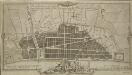
A Plan for Rebuilding the City of London after the Great Fire in 1666; Designed by that Great Architect Sr Chrisr. Wren; & approved by King and Parliament, but unhappily defeated by Faction.
1 : 31680 This is an 18th-Century copy of Sir Christopher Wren's plan for rebuilding London after the great fire destroyed seven-eighths of the city. Wren, at this point an Oxford astronomer with comparatively little architectural experience, was among the first to present a plan to Charles II after the catastrophe. The narrow streets which had helped the fire's progress are replaced on his plan by monumental avenues radiating from piazzas. The influence of the classical buildings and formal street plans which Wren had studied in Paris are a clear influence. He also proposes the construction of a Thameside quay from Bridewell to the Tower, replacing the ramshackle wooden wharfside buildings with warehouses. A vignette of 'Thamesis' (the putative river god) with London burning in the background has been added in the lower margin. Wren's plan was never used. Perhaps due to his eargerness to produce a plan quickly, he was inaccurate in making his ground plan and did not consider contours adequately. Neither king nor parliament were to ever take it seriously despite the title's assertion that it was an approved plan. Wren, Christopher
A "plan of the city of London after the great fire in the year of our Lord 1666; with the modell of the new city according to the design and proposal of Sir Christopher Wren, Knt., etc., for rebuilding thereof;"
LARGE AND ACCURATE MAP OF THE CITY OF LONDON. Ichnographically describing all the Streets, Lanes, Alleys, Courts, Yards, Churches, Halls and Houses, &Amp;c
1 : 1200 Large map of London printed in 20 sheets featuring title along the top, city arms and dedication to the Lord Mayor, the Aldermen and Sheriffs of the city in cartouche at top left and arms of Sheldon, Lord Mayor at top right and with compass star and dividers at bottom centre. This is the first accurate and detailed map of London, with all the buildings represented in plan rather than as bird's eye views. Ogilby, John and Morgan, William
A new and exact plan of the city of London and suburbs thereof, 2
1 Blatt : 60 x 51 cm Henry Overton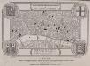
LABYRINTHUS LONDINENSIS or THE EQUESTRIAN PERPLEXED
The author of this small plan of London invites his readers to find their way around the city, from the Strand to St. Paul's, avoiding the many roads closed for repair. The plan's title appears at the top, with the royal Arms at the top left, the city arms at the top right, the arms of Bridge House at the bottom right and the arms of Westminster at the bottom left. A note explains the rules of the puzzle in the panel below the plan. Ingrey, Charles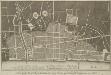
Sr. Cristopher Wren's Plan for Rebuilding the City after the dreadfull Conflagration in 1666
1 : 31680 This is an eighteenth-century copy of Sir Christopher Wren's plan for rebuilding London after the great fire destroyed seven-eighths of the city. This reduced plan seems to have been published a number of times. This latest edition has a textual explanation beneath the map. When Wren made his plan for rebuilding he was an Oxford astronomer with comparatively little architectural experience, but he was among the first to present a reconstruction plan after the catastrophe. On this plan the narrow streets which had helped spread the fire are replaced by monumental avenues. The influence of the classical buildings and formal street plans which Wren had studied in Paris are a clear influence. Wren also proposed constructing a Thameside quay from Bridle to the Tower, replacing the ramshackle wooden wharfside buildings with warehouses. A vignette of 'Thamesis' (a putative river god), a female personification of the city, and London burning in the background have been added to the border. Wren's plan was never used. Perhaps due to his eagerness to produce a plan quickly, he was inaccurate in making his ground plan and did not consider contours adequately. Neither king nor parliament were ever to take it seriously, despite title's the assertion that it was 'unhappily defeated by faction.' Wren, Christopher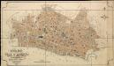
General Plan of the City of London
Haywood, William London
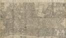
PLAN OF THE CITY OF LONDON DIVIDED INTO WARDS
This plan was published in Allen's 'History of London' of 1828. Its title and a list of the city wards feature below the plan, with ward boundaries indicated by a dotted line. City wards were created in the Norman era with aldermen elected for life for the purpose of government. Ward 'beadles' were employed fulltime with responsibility for the "preservation of peace, supervision of trading, sanitation and local upkeep". Allen, Thomas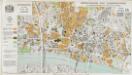
Greater London Plan 1944. By Patrick Abercrombie
Abercrombie, Patrick His Majesty's Stationery Office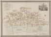
GENERAL PLAN OF THAT PART OF THE CITY OF LONDON THAT WAS DESTROYED BY THE GREAT FIRE OF 1666; SHOWING THE PRESENT STATE THEREOF
1 : 2431 This retrospective map compares pre-fire London with the city of the 1830s. The title and publisher's imprint appear at top left, with a reference table at bottom right, scale bar at bottom centre, and woodcut view of the Temple at top right. The map shows churches, halls and public buildings destroyed in the fire in grey,with contemporary buildings in pink. Wishaw, Francis