Maps of Kent

A Coloured Chart of the Course of the Rivers Thames and Medway, and of the Coasts of Kent and Sussex to Shoreham, with an Account of the Tides
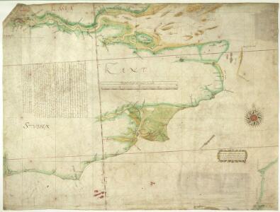
This manuscript map of the south-east coast of England can be dated to around 1596. Although unsigned the handwriting suggests a possible attribution to [William] Borough who is known for his work as a harbour consultant .The map is concerned with the defence of the Thames and of London itself which was threatened by the Anglo-Spanish war. Raids on transatlantic shipping by English seamen such as Francis Drake and England’s support of the Protestant rebellion in the Spanish ruled Netherlands had induced the Catholic Philip II to plan an invasion of England. Although the Spanish armada was defeated by the English in 1588, England remained at war with Spain for many years and further attempts to invade were made by Philip of Spain. It is thought that this map was drawn between the dispersal of the "second Armada" in October 1596 and the assembly of the third Armada’ in the following spring. The draughtsman has borrowed topographical and hydrographic information from contemporary sources, maps by Symonson and Robert Norman. The careful attention given to the coast line around Rye and the differentiation between the original line of the cliffs and the deposits which created Romney Marsh is striking. [Borough, William]
Carte du comté de Kent et du pas de Calais
1 Karte : Kupferdruck ; 55 x 82 cm Bellin s.n.
Ordnance Survey of England and Wales (Aeronautical map)
Great Britain. War Office. General Staff. Geographical Section [London] : [Air Ministry],
England and Wales[OS civil air edition]
Ordnance Survey
Sheet 12 England, South East & London, uit: Maps of England & Wales : scale 4 miles to 1 inch / Ordnance Survey
1 : 253440 titelvariant: Maps of England and Wales; Annotatie: Titel op cassette; Met bladoverzicht op de achterzijde van de cassette; Annotatie geografische gegevens: Hoogtelijneninterval 200 ft Ordnance Survey, United Kingdom Southampton : Ordnance Survey Office
A new travelling map of the country round London, 4
1 Blatt : 49 x 60 cm J. Andrews & A. Drury
Cantium Vernacule Kent. [Karte], in: Theatrum orbis terrarum, sive, Atlas novus, Bd. 4, S. 211.
1 Karte aus Atlas Blaeu, Joan Blaeu, Willem Janszoon
Cantium Vernacule Kent. [Karte], in: Le théâtre du monde, ou, Nouvel atlas contenant les chartes et descriptions de tous les païs de la terre, Bd. 4, S. 187.
1 Karte aus Atlas Blaeu, Willem Janszoon und Blaeu, Joan Blaeu, Willem Janszoon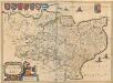
Cantium Vernacule Kent. [Karte], in: Theatrum orbis terrarum, sive, Atlas novus, Bd. 4, S. 211.
1 Karte aus Atlas Blaeu, Joan Blaeu, Willem Janszoon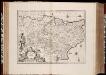
Cantium vernacule Kent / [Joannes Janssonius]
1 : 200000 Annotatie: Oorspr. verschenen in: Ioannis Ianssonii Atlas Novus ... - Amstelodami : apud Iohannem Ianssonium, 1646; Origineel is Blad 29 in atlas factice Janssonius, Joannes (jr.) (1588-1664) Amstelodami : apud Ioannem Ianssonium
Cantium Vernacule Kent. [Karte], in: Novus atlas absolutissimus, Bd. 7, S. 122.
1 Karte aus Atlas Janssonius Offizin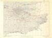
Britain, defences South of England and Wales
[London] : Ministry of Home Security
Kent
Stent, Peter, Symonson, Philip and Whitwell, Charles Ordnance Survey
Der Kanal
1 : 150000 Dover (Anglie) Reichs-Marine-Amt
[Paskaert vande Zeeuse Vlaemse en Engelse Kusten [...]] [nordwestlicher Küstenabschnitt mit Teil der südöstlichen englischen Küste] [Karte], in: De Nieuwe Groote Vermeerderde Zee-Atlas ofte Water-Werelt, S. 37.
1 Karte aus Atlas Doncker, Hendrick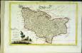
Provincia di Kent
1 Karte : Kupferdruck ; 18 x 29 cm Zatta; Zuliani; Pitteri presso Antonio Zatta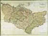
A map of the county of Kent
1 Karte : Kupferdruck ; 49 x 70 cm Kitchin; Dury; Andrews; Herbert A. Dury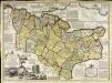
An accurate map of the county of Kent
1 Karte : Kupferdruck ; 50 x 69 cm Bowen; Hinton sold by J. Hinton at the Kings Arms in St. Pauls Church Yard
Cantivm vernacule Kent
1 Karte : Kupferdruck ; 37 x 51 cm Blaeu Joan Blaeu
CANTIVM | Vernacule | KENT.
[Amsterdam : Joan Blaeu]
Cantium vernacule Kent
1 : 130000 Amstelodami : apud Joannem Janssonium

Kent, Sheet 31 - Bartholomew's "Half Inch to the Mile Maps" of England & Wales
1 : 126720 Topographic maps Bartholomew, John George John Bartholomew & Co
Sheets 17-18. (Cary's England, Wales, and Scotland).
1 : 360000 Cary, John, ca. 1754-1835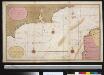
Een gedeelte van het Kanaal van de Hoofden tot den hoek van Bevesier als meede een gedeelte van de cust van Vrankrijk
English Channel Gerard van Keulen
Suthsexia. Vernacule Sussex. [Karte], in: Novus atlas absolutissimus, Bd. 7, S. 137.
1 Karte aus Atlas Janssonius Offizin
Bouche de la Tamise
1 Karte : Kupferdruck ; 22 x 28 cm Le Rouge Georges Louis Le Rouge
Suthsexia vernacule Sussex
1 : 240000 Amstelodami : apud Joannem Janssonium

Suthsexia vernacule Sussex
1 Karte : Kupferdruck ; 36 x 49 cm Valck; Schenk apud Gerardum Valk et Petrum Schenk