Maps of Kent

Kent
Stent, Peter, Symonson, Philip and Whitwell, Charles Ordnance Survey
Cantium Vernacule Kent. [Karte], in: Novus atlas absolutissimus, Bd. 7, S. 122.
1 Karte aus Atlas Janssonius Offizin
Cantium Vernacule Kent. [Karte], in: Theatrum orbis terrarum, sive, Atlas novus, Bd. 4, S. 211.
1 Karte aus Atlas Blaeu, Joan Blaeu, Willem Janszoon
Cantium Vernacule Kent. [Karte], in: Le théâtre du monde, ou, Nouvel atlas contenant les chartes et descriptions de tous les païs de la terre, Bd. 4, S. 187.
1 Karte aus Atlas Blaeu, Willem Janszoon und Blaeu, Joan Blaeu, Willem Janszoon
Cantium Vernacule Kent. [Karte], in: Theatrum orbis terrarum, sive, Atlas novus, Bd. 4, S. 211.
1 Karte aus Atlas Blaeu, Joan Blaeu, Willem Janszoon
Cantium vernacule Kent
1 : 130000 Amstelodami : apud Joannem Janssonium
Cantium vernacule Kent / [Joannes Janssonius]
1 : 200000 Annotatie: Oorspr. verschenen in: Ioannis Ianssonii Atlas Novus ... - Amstelodami : apud Iohannem Ianssonium, 1646; Origineel is Blad 29 in atlas factice Janssonius, Joannes (jr.) (1588-1664) Amstelodami : apud Ioannem Ianssonium
CANTIVM | Vernacule | KENT.
[Amsterdam : Joan Blaeu]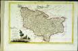
Provincia di Kent
1 Karte : Kupferdruck ; 18 x 29 cm Zatta; Zuliani; Pitteri presso Antonio Zatta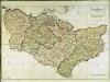
A map of the county of Kent
1 Karte : Kupferdruck ; 49 x 70 cm Kitchin; Dury; Andrews; Herbert A. Dury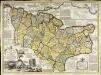
An accurate map of the county of Kent
1 Karte : Kupferdruck ; 50 x 69 cm Bowen; Hinton sold by J. Hinton at the Kings Arms in St. Pauls Church Yard
Cantivm vernacule Kent
1 Karte : Kupferdruck ; 37 x 51 cm Blaeu Joan Blaeu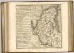

A Coloured Chart of the Course of the Rivers Thames and Medway, and of the Coasts of Kent and Sussex to Shoreham, with an Account of the Tides
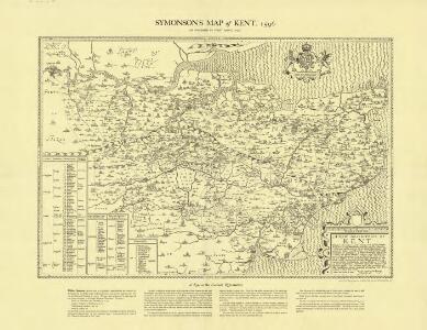
This manuscript map of the south-east coast of England can be dated to around 1596. Although unsigned the handwriting suggests a possible attribution to [William] Borough who is known for his work as a harbour consultant .The map is concerned with the defence of the Thames and of London itself which was threatened by the Anglo-Spanish war. Raids on transatlantic shipping by English seamen such as Francis Drake and England’s support of the Protestant rebellion in the Spanish ruled Netherlands had induced the Catholic Philip II to plan an invasion of England. Although the Spanish armada was defeated by the English in 1588, England remained at war with Spain for many years and further attempts to invade were made by Philip of Spain. It is thought that this map was drawn between the dispersal of the "second Armada" in October 1596 and the assembly of the third Armada’ in the following spring. The draughtsman has borrowed topographical and hydrographic information from contemporary sources, maps by Symonson and Robert Norman. The careful attention given to the coast line around Rye and the differentiation between the original line of the cliffs and the deposits which created Romney Marsh is striking. [Borough, William]
Bouche de la Tamise
1 Karte : Kupferdruck ; 22 x 28 cm Le Rouge Georges Louis Le Rouge
Kent, Sheet 31 - Bartholomew's "Half Inch to the Mile Maps" of England & Wales
1 : 126720 Topographic maps Bartholomew, John George John Bartholomew & Co
London SE - OS One-Inch Map
1 : 63360 Topographic maps Ordnance Survey Ordnance Survey
Chatham and Maidstone - OS One-Inch Map
1 : 63360 Topographic maps Ordnance Survey Ordnance Survey
East Kent - OS One-Inch Map
1 : 63360 Topographic maps Ordnance Survey Ordnance Survey
To the Right Honorable the Master, Wardens, and Elder Brethren, of the Trinity House, this chart of the Downs and Margate Roads is ... dedicated
1 : 56000 Heather, W. (William) Heather, W. (William)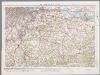
[Kaart], uit: S.E. London & Sevenoaks
1 : 64000 titelvariant: Ordnance Survey contoured road map of S.E. London and Sevenoaks; Annotatie: Omslagtitel: Ordnance Survey contoured road map of S.E. London and Sevenoaks Ordnance Survey Southampton : The Director General, at the Ordnance Survey Office
London passenger transport map
Ordnance Survey
London passenger transport map
Ordnance Survey
A sketch of the roads within fourteen miles of Tunbridge Wells
1 : 100000 Brackett, William Clifford, J J. Clifford
Hastings - OS One-Inch Map
1 : 63360 Topographic maps Ordnance Survey Ordnance Survey
The description of Romney Marsh, Walland, Marshy, Denge and Gulforde marsh, with the divisions of their waterings, heads, armes, principal sewers and their gutts
This is a map of the Romney Marsh area, dating from around 1590. It shows the network of sewers and waterways in the area and is principally concerned with drainage. The locations of bridges are carefully recorded. The topography of the landscape is depicted with hills, trees, churches, towns, villages and windmills shown pictorially. A small island in the sea records the location where a village once stood. Camber castle is shown and the draughtsman has attempted to indicate the actual architectural features of the castle.
Partie de l'Angleterre
1 : 110000 Anglie jižní Fricx, Eugene Henry Harrewyn, Jacques chez Eugene Henry Fricx
Croydon
1 : 31680 Woodland and agricultural land dominate this plan, which covers an area from Beckenham and Croydon at the top, to Felbridge, Hackenham and Gotwick at the bottom. Buildings are infilled and blocked together at Croydon, the largest settlement shown.
A Chart of Rye Harbour, the Island of Oxney, and the Adjacent Country
This is a map of Rye Harbour and the Isle of Oxney, dating from around 1600. Positioned on the estuary of the River Rother, Rye affords a clear view of the Romney Marches, making it a valuable post for coastal defence. Places are represented by elevation views of buildings. The concern with coastal defence at this date was due to England’s continuing war with Spain. Although the Spanish Armada was defeated in 1588 Philip II attempted further invasions during the 1590’s. A scale bar showing ‘myles and furlonges’ is included. The practical use of this map is hinted at by the differentiation in the presentation of domestic townscape views, shown in pictorial elevation, and the plan form that represents Camber Castle, a defensive military structure. A scale bar showing ‘myles and furlonges’ is included.