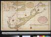
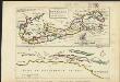
Mappa ÆSTIVARVM Insularum, | alias BARMVDAS dictarum, ad Ostia | Mexicani æstuarij jacentium in latitudine Gra- | duum 32 Minutorum 25. Ab Anglia, Londino | Scilicet versus Libonotum 3300 Miliaribus | Anglicanis, et a Roanoack (qui locus est | in Virginia) versus Euronotum 500 Mill. | accurate descripta
Amstelodami, Guiljelm. Blaeuw excudit

Mappa Aestivarum Insularum, alias Barmudas dictarum [...] accurate descripta. [Karte], in: Theatrum orbis terrarum, sive, Atlas novus, Bd. 2, S. 324.
1 Karte aus Atlas
Blaeu, Joan
Blaeu, Willem Janszoon
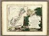
Mappa Aestivarum Insularum, alias Barmudas dictarum [...] accurate descripta. [Karte], in: Gerardi Mercatoris et I. Hondii Newer Atlas, oder, Grosses Weltbuch, Bd. 2, S. 389.
1 Karte aus Atlas
Mercator, Gerhard und Hondius, Jodocus
Jansson, Jan

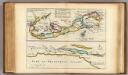
Mappa Aestivarum Insularum, alias Barmudas dictarum, ad Ostia Mexicani [...] [Karte], in: Novus Atlas, das ist, Weltbeschreibung, Bd. 2, S. 322.
1 Karte aus Atlas
Blaeu, Joan
Blaeu, Willem Janszoon

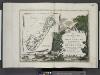
Mappa Aestivarum Infularum, alias Barmudas dictarum, ad Ostia Mexicani estuary jacentium in latitudine Graduum 32 Minutorum 25. Ab Anglia, Londino Scilicet versus Libonotum 3300 Miliaribus Anglicanis, ...
from America: being the latest, and most accurate description of the Nevv vvorld; containing the original of the inhabitants, and the remarkable voyages thither. The conquest of the vast empires of Mexico and Peru, and other large provinces and territories, with the several European plantations in those parts. Also their cities, fortresses, towns, temples, mountains, and rivers. Their habits, customs, manners, and religions. Their plants, beasts, birds, and serpents. With an appendix, containing, besides several other considerable additions, a brief survey of what hath been discover'd of the vnknown south-land and the Arctick region. Collected from most authentick authors, augmented with later observations, and adorn'd with maps and sculptures, by John Ogilby ...

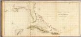
A Map of the British and French settlements in North America: (part the second) containing part of New York, Pensilvania, New Jersey, Mary Land, Virginia, North & South Carolina, Georgia, Louisiana, and all the countries westward in the same parellels so far as discovered, shewing the course of the Rivers Ohio, Missisipi &c. exhibiting the just boundaries & the French encroachments laid down from authentic surveys / T. Bowen, sc.
from Parts
T. Bowen,