Maps of Dukes County
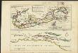
The island of Bermudos divided into its tribes, with the castles, forts &c. ; [Part of Providence Island]
1 : 1
Siasconset
1 : 100000
Siasconset
1 : 100000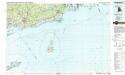
Block Island
1 : 100000
From Monomoy and Nantucket Shoals to Muskeget Channel, Mass.
1 : 80000 U.S. Coast and Geodetic Survey U.S. Coast and Geodetic Survey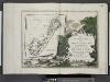
Le colonie unite dell' America settentrle ... [Title page]; Le Isole Bermude.
from Le colonie unite dell' America settentrle : di nuova projezione a s.s.e.e. li Signori Riformatori dello Studio di Padova.
Martha's Vineyard : Dukes County, Massachusetts
1 : 85000 Tripp, B. Ashburton, 1887-1955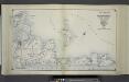
Index Map No. 2 of a part of Suffolk County. South Side - Ocean Shore, Long Island. Easthampton. Published by E. Belcher Hyde. 97 Liberty Street, Brooklyn. 5 Beekman Street, Manhattan. 1916. Volume Two.
from Atlas of ... Suffolk County, Long Island, New York ... : based upon actual measurements by our own corps of engineers, maps on file at county offices, also maps from actual surveys furnished by individual owners / under the supervision of Merritt B. Hyde.
Heathers, improved chart of the Bermudas, drawn from the best surveys
1 : 141000 Heather, W. (William) Heather, W. (William)
Newport
1 : 125000
Nantucket
1 : 125000
Mappa Aestivarum Infularum, alias Barmudas dictarum, ad Ostia Mexicani estuary jacentium in latitudine Graduum 32 Minutorum 25. Ab Anglia, Londino Scilicet versus Libonotum 3300 Miliaribus Anglicanis, ...
from America: being the latest, and most accurate description of the Nevv vvorld; containing the original of the inhabitants, and the remarkable voyages thither. The conquest of the vast empires of Mexico and Peru, and other large provinces and territories, with the several European plantations in those parts. Also their cities, fortresses, towns, temples, mountains, and rivers. Their habits, customs, manners, and religions. Their plants, beasts, birds, and serpents. With an appendix, containing, besides several other considerable additions, a brief survey of what hath been discover'd of the vnknown south-land and the Arctick region. Collected from most authentick authors, augmented with later observations, and adorn'd with maps and sculptures, by John Ogilby ...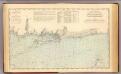
Niantic Bay-Rocky Pt.
1 : 80000 United States Coast Survey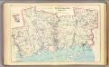
New London Co. S.
1 : 72000 D.H. Hurd & Co.
Southold and Shelter Island, Suffolk Co. L.I. - Village, North of Greensport, Town of Southold, Suffolk Co. - Part of Town of Southold.
from Atlas of Long Island, New York. From recent and actual surveys and records.
British West Indian Possessions, Northern.
Fullarton, A. & Co.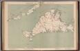
Massachusetts. Atlas Plate No. 11.
1 : 63360 Walker, O.W.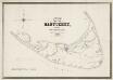
Map of the island of Nantucket : including Tuckernuck
1 : 40000 Mitchell, William, 1791-1868 E.W. Bouvé's drawing and lithography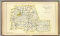
Middlesex Co. N.
1 : 60000 D.H. Hurd & Co.
Nantucket quadrangle, Massachusetts
1 : 62500 Geological Survey (U.S.) U.S. Geological Survey
Gay Head quadrangle, Massachusetts
1 : 62500 Geological Survey (U.S.) U.S. Geological Survey
Martha's Vineyard quadrangle, Massachusetts
1 : 62500 Geological Survey (U.S.) U.S. Geological Survey
Muskeget quadrangle, Massachusetts
1 : 62500 Geological Survey (U.S.) U.S. Geological Survey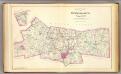
New London Co. N.
1 : 72000 D.H. Hurd & Co.
Mappa Aestivarum Insularum, alias Barmudas dictarum, ad Ostia Mexicani [...] [Karte], in: Novus Atlas, das ist, Weltbeschreibung, Bd. 2, S. 322.
1 Karte aus Atlas Blaeu, Joan Blaeu, Willem Janszoon
Mappa Aestivarum Insularum, alias Barmudas dictarum [...] accurate descripta. [Karte], in: Gerardi Mercatoris et I. Hondii Newer Atlas, oder, Grosses Weltbuch, Bd. 2, S. 389.
1 Karte aus Atlas Mercator, Gerhard und Hondius, Jodocus Jansson, Jan
Mappa Aestivarum Insularum, alias Barmudas dictarum [...] accurate descripta. [Karte], in: Theatrum orbis terrarum, sive, Atlas novus, Bd. 2, S. 324.
1 Karte aus Atlas Blaeu, Joan Blaeu, Willem Janszoon
Mappa Aestivarum Insularum, alias Barmudas dictarum [...] accurate descripta. [Karte], in: Novus atlas absolutissimus, Bd. 6, S. 213.
1 Karte aus Atlas Janssonius Offizin
East Hampton, Suffolk Co. L.I.
from Atlas of Long Island, New York. From recent and actual surveys and records.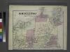
![The island of Bermudos divided into its tribes, with the castles, forts &c. ; [Part of Providence Island]](https://images-2.georeferencer.com/images/iiif/539360203915/full/,300/0/native.jpg)

