Maps of Languedoc-Roussillon

Galliae Narbonensis Ora Marittima Recenter descripta. [Karte], in: Theatrum orbis terrarum, S. 37.
1 Karte aus Atlas Ortelius, Abraham
GVBERNATIO GENERALIS LANGVEDOCIAE OCCITANIA olim dictae
1 : 670000 Languedoc (Francie) Nolin, Jean-Baptiste studio Homannianorum Heredum
GVBERNATIO GENERALIS LANGVEDOCIAE OCCITANIA olim dictae
1 : 670000 Languedoc (Francie) Nolin, Jean-Baptiste studio Homannianorum Heredum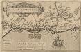
Gallia Narbonens. [Karte], in: Theatrum orbis terrarum, S. 146.
1 Karte aus Atlas Ortelius, Abraham Vrients, Jan Baptista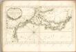

Languedoc, orientale.
1 : 570000 Covens et Mortier
Carte de France, 11
2 Blätter : Kupferdruck ; 53 x 45 cm Crepy
Partie orientale du gouvernement general de Languedoc
1 Karte : Kupferdruck ; 57 x 45 cm chez I. Covens et C. Mortier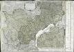
Gouvernemens généraux de Languedoc, de Foix, et de Roussillon
1 Karte : Kupferdruck ; 51 x 65 cm Robert de Vaugondy; Arrivet; Fortin chéz Fortin ing.r mécanicien du roy pour les globes et sphères rue de la Harpe pres la rue du Foin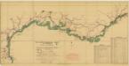
France [Mediterranean coast of]
The Mediterranean Coast of France, from the Spanish frontier to the Italian frontier. Beaches & landrings. Compiled and drawn by Inter-Service Topographical Department. G.S.G.S Misc. 50. [London] : War Office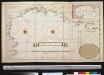
De kust van Provence en de Golf van Narbonne int groot
France Gerard van Keulen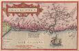
Gallia Narbonens. [Karte], in: Theatrum orbis terrarum, S. 89.
1 Karte aus Atlas Ortelius, Abraham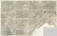
Composite 15: Carte de France.
1 : 86400 Cassini family; Cassini, Cesar-Francois, 1714-1784
[Languedoc]
Languedoc (Francie) Valk, Gerhard G. Valk

Galliae Narbonensis ora maritima recenter descripta
1 Karte : Kupferdruck ; 29 x 21 cm Ortelius s.n.
Gouvernement general de Languedoc qui comprend deux generalitéz sçavoir la generalité de Toulouse et celle de Montpellier, 2
1 Blatt : 79 x 48 cm Jaillot
Gouvernement general de Languedoc qui comprend deux generalitéz sçavoir la generalité de Toulouse et celle de Montpellier, 2
1 Blatt : 81 x 49 cm Jaillot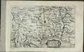
Langvedocia
1 Karte : Kupferdruck ; 15 x 22 cm Lambert Andreae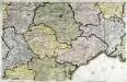
Carte de la France, no. 15
1 Blatt : 58 x 90 cm s.n.
Carte dv Languedoc
1 Karte : Kupferdruck ; 11 x 15 cm Sebastian Cramoisy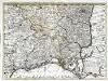
Partie des Sevennes, et le bas Vivarais, le diocese de Monpelliers, et de Nismes [et]c
1 Karte : Kupferdruck ; 42 x 57 cm chez I. Cóvens et C. Mortier
France Géologie
Vidal de La Blache, Paul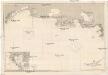
Mittelmeer
1 : 150000 Marseille (Francie) Reichs-Marine-Amt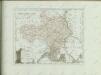

41) XII.S.O. ''Marseille'', uit: Carte géologique de France
1 : 500000 Annotatie: Voor aanwezige bladen zie bladoverzicht [S.l : s.n.]
Partie orientale du gouvernement general de Languedoc
1 Karte : Kupferdruck ; 58 x 46 cm Fer; Starckman; Bénard chez Benard dans l'isle du Palais a la sphere royale
Département de l'Herault
1 Karte : Kupferdruck ; 48 x 53 cm Houdan; Dumez chez Dumez directeur de l'Atlas national rue de la Harpe no. 26, et au dépôt de cet atlas placé au cabinet bibliograph. rue de la Monnoye no. 5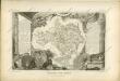

![Galliae Narbonensis Ora Marittima Recenter descripta. [Karte], in: Theatrum orbis terrarum, S. 37.](https://images-2.georeferencer.com/images/iiif/693488689657/full/,300/0/native.jpg)

