Maps of March

Nova descriptio ditionis Tigurinae regionumque finitimarum
1 : 95000 1 Karte auf 6 Bl. Joh. Conradus Gygerus, P. delineavit ; Joh. Georgius Gygerus, F. in aes incidi ; curavit per Johannem Meyerum Ao. 1685
Nova descriptio ditionis Tigurinæ, regionumque finitimarum, 2
1 Blatt : 50 x 36 cm Johann Jost Hiltensperger
Nova descriptio ditionis Tigurinæ, regionumque finitimarum, 2
1 Blatt : 50 x 36 cm s.n.
Unklare Grenze zwischen dem Zürcher und dem Schwyzer Gebiet bei Richterswil und auf der Altmatt; Übersichtsplan
1 : 42000 Ohne Datumsangabe (Datierung gemäss Angabe Samuel Wyders in: Grenz-, Zehnten- und Befestigungspläne des Zürcher Gebiets von Hans Conrad Gyger, S. 26-28). Gyger, Hans Conrad, andere Schreibweisen: Geiger, Geyger, (1599-1674), Kartograf, Ingenieur und Amtmann des Amts Kappelerhof, von Zürich
Nr. 7: Militärquartier Wädenswil; Übersichtskarte von 1659
Handgezeichnete Kopie der von Hans Conrad Gyger, andere Schreibweisen: Geiger, Geyger, (1599-1674), Kartograf, Ingenieur und Amtmann des Amts Kappelerhof, von Zürich, verfertigten Originalkarte. Spitteler, Sigmund (1732-1818), Ingenieur und Strassenbauinspektor des Kantons Zürich, von Läufelfingen BL und Hottingen
Wädenswil: Militärquartier samt den nächstangrenzenden Orten in den Schwyzer und Zuger Gebieten; Übersichtskarte
Originaltitel: Wedenschweiler Quartier-Carte samt denen nächst angrentzenden Orthen in dem Schweytzer und Züger-Gebiet bis auf zwey und drey Stunden weit: Situation und Beschaffenheit der Dörferen, Höfen, Stegen und Wegen, Flüssen, Bächen, Seen und Wälderen, in und umb dieselben herumb. Mit Illustrationen von Schanzen, Handels- und Kriegsschiffen. Mit Legende. Vogler, Joh. Felix, Pfarrer, in Richterswil
Nr. 7: Militärquartier Wädenswil; Übersichtskarte
1 : 45000 Originaltitel: Dess Wedischwyler Quartiers eygentliche verzeychnus, sammbt anderen nechst anstossenden Quartieren, vnnd Landtschafftenn. Gyger, Hans Conrad, andere Schreibweisen: Geiger, Geyger, (1599-1674), Kartograf, Ingenieur und Amtmann des Amts Kappelerhof, von Zürich
Topographische Karte des Kantons St. Gallen mit Einschluss des Kantons Appenzell (Eschmann-Karte): Blatt Rapperswil
1 : 25000 Aufnahme: Eberle, Joseph Meinrad (1809-1896), Ingenieur Stich: Steiner, P.; Leuzinger, Rudolf (1826-1896), Kartograf und Lithograf, von Netstal GL und Mollis GL Gebirgszeichnung und Leitung des Stichs: Ziegler, Jakob Melchior (1801-1883), Kartograf Stich und Druck: Joh. Wurster und Comp., in Winterthur
Kanton Zürich: Staats-, Gemeinde- und Genossenschaftswaldungen: Blatt 15: Gegend bei Rüti; Situationsplan
1 : 25000 Auf Ausgangskarten angebrachte farbige Eintragungen und Einzeichnungen. Ohne Erstellungsdatumsangabe. Ausgangskarten: Blätter 229 (Rapperswil), 232 (Schmerikon), 243 (Lachen) und 246 (bis Schübelbach) des Topographischen Atlasses der Schweiz (Siegfried-Karte). Hartmann, Karl, Forstadjunkt im Zürcher Oberforstamt, von Aarau, in Unterstrass
Hans Konrad Gyger's Züricher-Cantons-Carte 1667
1 : 32000 1 Karte in 56 Teilen Hans Konrad Gyger
Topographische Karte des Cantons St. Gallen mit Einschluss des Cantons Appenzell
1 : 25000 Blatt 10 Eschmann, Johannes ; Steiner, P. ; Randegger, Johannes ; Ziegler, Jakob Melchior Topographische Anstalt v. Joh. Wurster & Comp.
Landeskarte der Schweiz 1 : 25000: Den Kanton Zürich betreffende Blätter: Blatt 1132: Einsiedeln SZ
1 : 25000 Erstausgabe 1954; Nachführung 1953. Eidgenössische Landestopographie, in Köniz-Wabern
Landeskarte der Schweiz 1 : 25000: Den Kanton Zürich betreffende Blätter: Blatt 1132: Einsiedeln SZ
1 : 25000 Erstausgabe 1954; Nachführungen 1960, 1971, 1978, 1983, 1989, 1996, 2002. Bundesamt für Landestopografie swisstopo, in Köniz-Wabern
Landeskarte der Schweiz 1 : 25000: Den Kanton Zürich betreffende Blätter: Blatt 1132: Einsiedeln SZ
1 : 25000 Erstausgabe 1954; Nachführungen 1960, 1971. Eidgenössische Landestopographie, in Köniz-Wabern
Richtersweil
1 : 25000 1 Karte [Lithographie: Johann Jakob Brack]
Lachen
1 : 25000 1 Karte [Lithographie: Johann Jakob Brack]
Richtersweil
1 : 25000 1 Karte [Lithographie: Josef Graf]
Landeskarte der Schweiz 1 : 25000: Den Kanton Zürich betreffende Blätter: Blatt 1132: Einsiedeln SZ
1 : 25000 Erstausgabe 1954; Nachführungen 1960, 1971, 1978, 1983. Bundesamt für Landestopographie, in Köniz-Wabern
Landeskarte der Schweiz 1 : 25000: Den Kanton Zürich betreffende Blätter: Blatt 1132: Einsiedeln SZ
1 : 25000 Stand des Karteninhalts: 2013. Bundesamt für Landestopografie swisstopo, in Köniz-Wabern
Landeskarte der Schweiz 1 : 25000: Den Kanton Zürich betreffende Blätter: Blatt 1132: Einsiedeln SZ
1 : 25000 Erstausgabe 1954; Nachführungen 1960, 1971, 1978, 1983, 1989, 1996. Bundesamt für Landestopographie, in Köniz-Wabern
Topographische Karte des Cantons St. Gallen mit Einschluss des Cantons Appenzell
1 : 25000 16 Karten aufgenommen von J. Eschmann ... [et al.] ; gestochen von P. Steiner ; Gebirg von J. Randegger ; Gebirgszeichnung u. Leitung des Stiches durch J.M. Ziegler Topographische Anstalt v. Joh. Wurster & Comp., Winterthur
Landeskarte der Schweiz 1 : 25000: Den Kanton Zürich betreffende Blätter: Blatt 1132: Einsiedeln SZ
1 : 25000 Erstausgabe 1954; Nachführungen 1960, 1971, 1978, 1983, 1989, 1996, 2002, 2007, 2008. Bundesamt für Landestopografie swisstopo, in Köniz-Wabern
Topographische Karte des Cantons St. Gallen mit Einschluss des Cantons Appenzell
1 : 25000 Blatt 9 Eschmann, Johannes ; Steiner, P. ; Randegger, Johannes ; Ziegler, Jakob Melchior Topographische Anstalt v. Joh. Wurster & Comp.
Landeskarte der Schweiz 1 : 25000: Den Kanton Zürich betreffende Blätter: Blatt 1132: Einsiedeln SZ
1 : 25000 Erstausgabe 1954; Nachführungen 1960, 1971, 1978, 1983, 1989. Bundesamt für Landestopographie, in Köniz-Wabern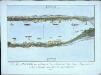
Le lac de Zürich avec ses environs, du côté de l'orient depuis Üetikon jusqua à Rapperschweil, du côte de l'occident depuis lisle de Au jusqua à Rapperschweil
1 Blatt : 35 x 47 cm Johannes Hofmeister
Vue des environs et situation entre Rapperschweil et Richtenschweil
1 : 20000 1 Karte
Projektierte Eisenbahnstrecke Wädenswil-Einsiedeln; Übersichtskarte
Ausgangskarte: Ausschnitt aus der Topographischen Karte der Schweiz (Dufour-Karte). Benzinger, in Einsiedeln Ausgangskarte: Leitung: Dufour, Guillaume-Henri (1787-1875), General, Politiker, Ingenieur und Kartograf, von Genf; Eidgenössisches Topographisches Bureau, Genf
Hans Konrad Gyger's Züricher-Cantons-Carte 1667
1 : 32000 1 Karte in 56 Teilen Hans Konrad Gyger
Original-Messtischaufnahmen für die Topographische Karte des Kantons Zürich (Wild-Karte): Blatt 5: Wädenswil
1 : 25000 Wetli, Kaspar, andere Schreibweise: Wethli, (1822-1889), Ingenieur, von Männedorf


