Maps of India

[Decima Asie tabula] [Karte], in: Clavdii Ptholomei Viri Alexandrini Cosmographie, S. 185.
1 Karte aus Atlas Nicolaus Germanus [und Ptolemaeus, Claudius]
Decima Asie Tabula [Karte], in: [Clavdii Ptholomei Cosmographi ...], S. 329.
1 Karte aus Atlas Nicolaus Germanus [und Ptolemaeus, Claudius]
Inde. Asie Centrale.
1 : 10806700 Migeon, J.
Atlas für Handel und Industrie: Für Kaufleute, Fabrikante u. Gewerbetreibende, Handlungs- u. Gewerbe-Schulen

Hindoostan.
1 : 34000000 Fenner, Rest.
93-94. India.
1 : 7500000 Touring club italiano
Composite: Indien, Inner-Asien in 2 Blattern.
1 : 7500000 Petermann, A.
Centralasien, Ostindien.
1 : 10000000 Andree, Richard
Central Asia, India.
1 : 10000000 Andree, Richard; Times (London, England)
Composite: India.
1 : 5448960 Stanford, Edward
134-135. India, Pakistan, Ceylon, Nepal, Political. The World Atlas.
1 : 7500000 USSR (Union of Soviet Socialist Republics).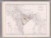
India and Adjacent Countries. Coal Resources of the World.
1 : 8553600 McInnes, William; Leach, W.W.; Dowling, D.B.
Density of the population in Peninsular India
Tabula Asiae X. [Karte], in: Claud. Ptolemaeus. Geographia lat. cum mappis [...], S. 323.
1 Karte aus Atlas Münster, Sebastian [und Ptolemaeus, Claudius]
1 Partie de la nouvelle grande carte des Indes Orientales, contenant les terres du Mogol, Surate, Malabar, Cormandel, Bengale, Aracan, Pegu, Siam, Camboje, Tonquin & une partie de la Chine
1 : 8000000 dressée avec soin, sur plusieurs cartes munuscrites, par un habile connoisseur, & publiée A Amsterdam : par R. & J. Ottens
Decima Asiae Tabula [Karte], in: Claudii Ptolemei viri Alexandrini mathematice discipline philosophi doctissimi geographie opus [...], S. 220.
1 Karte aus Atlas Waldseemüller, Martin [und Ptolemaeus, Claudius] Übelin, Georg
India, 34
1 : 8500000 Appleton, D. & Co.
Language Map of India and ist Border Lands
India and Indochina. Pergamon World Atlas.
1 : 10000000 Polish Army Topography Service
India
1 : 15000000 J.W. Clement Co.
Hindoostan or India.
1 : 20000000 Seaman, James V.
The British Possessions In The East Indies.
1 : 6969600 Fullarton, A. & Co.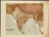
The Indian Empire and Ceylon
1 : 7500000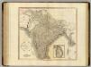
Hindoostan, Ceylon.
1 : 6900000 Cary, John, ca. 1754-1835
India
1 : 8000000 Afghánistán James, J. O. N. Surveyor general's office
India.
1 : 9000000 Colton, G.W.
Tabula Asiae X. [Karte], in: Geographia universalis vetus et nova complectens Claudii Ptolemaei Alexandrini enarrationis libros VIII, S. 293.
1 Karte aus Atlas Münster, Sebastian [und Ptolemaeus, Claudius]
Ost-Indien oder Vorder-Indien
Schul-Atlas in 36 Karten Völter, Daniel Verlag der J.M. Dannheimer'schen Buchhandlung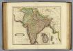
Hindostan.
1 : 8500000 Lizars, Daniel
![[Decima Asie tabula] [Karte], in: Clavdii Ptholomei Viri Alexandrini Cosmographie, S. 185.](https://images-2.georeferencer.com/images/iiif/011862069741/full/,300/0/native.jpg)

