Maps of Bezirk Baden
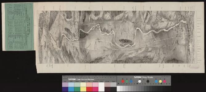
<<Die>> Schweizerische Nordbahn
1 Vogelschaukarte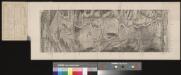
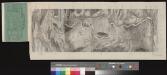
<<Die>> Schweizerische Nordbahn
1 Vogelschaukarte
Geometrischer Grund-Riss aller Marken der Gerichts-Herrlikeit dess Gottshauses Wettingen
1 : 30000 1 Karte ex Joh. Conr. Gygeri tabula majore delineavit et hanc in formam traduxit P. Eugenius Speth ; Joh. Meyer chalco-graphus sculpsit
<<Die>> Schweizerische Nordbahn
1 Vogelschaukarte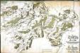
Die Graffschafft Baden, samt dem unteren Theil des Freÿen=Amts
1 Manuskriptkarte auf 12 Blatt : 80 x 120 cm Riediger s.n.
Schlacht bei Zürich am 22 September 1799
1 : 79000 1 Karte
Geometrischer Grund-Riss aller Marken der Gerichts-Herrlikeit dess Gottshauses Wettingen
1 : 30000 1 Karte ex Joh. Conr. Gygeri tabula majore delineavit et hanc in formam traduxit P. Eugenius Speth ; Joh. Meyer chalco-graphus sculpsit
Uibergang der Franzosen über die Limmat und Schlacht bey Zürich am 25ten September 1799
1 : 30000 1 Karte gezeichnet von Ioseph Krottendorfer
Kanton Zürich: Wasserbenutzungsrechtkataster; Übersichtskarten: Bezirk Zürich
1 : 25000 Ausgangskarten (zusammengesetzt): Ausschnitte der Blätter 158 (Schlieren), 160 (Birmensdorf), 161 (Zürich) und 175 (Thalwil) des Topographischen Atlasses der Schweiz (Siegfried-Karte). Ausgangskarten Leitung: Siegfried, Hermann (1819-1879), Topograf und Kartograf, von Zofingen AG; Eidgenössisches Topographisches Bureau, in Bern
Triangulation entlang der Grenze zwischen den Kantonen Zürich und Aargau von Kaiserstuhl AG bis zur Reuss; Übersichtsplan
1 : 25000 Schlegel, A.; Stambach, J., Ingenieur
Nr. 9: Militärquartier Regensberg; Übersichtskarte von 1644
Handgezeichnete Kopie der von Hans Conrad Gyger, andere Schreibweisen: Geiger, Geyger, (1599-1674), Kartograf, Ingenieur und Amtmann des Amts Kappelerhof, von Zürich, verfertigten Originalkarte. Spitteler, Sigmund (1732-1818), Ingenieur und Strassenbauinspektor des Kantons Zürich, von Läufelfingen BL und Hottingen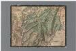
Nr. 9: Militärquartier Regensberg; Übersichtskarte
1 : 43500 Originaltitel: Dess Rägensperger Quartiers, Eygentliche verzeychnuss. Sampt den nechst daran gräntzenden Landtschafften. Gyger, Hans Conrad, andere Schreibweisen: Geiger, Geyger, (1599-1674), Kartograf und Ingenieur, von Zürich
Geometrischer Grund-Riss aller Marken der Gerichts-Herrlikeit dess Gottshauses Wettingen
1 : 30000 1 Karte ex Joh. Conr. Gygeri tabula majore delineavit et hanc in formam traduxit P. Eugenius Speth ; Joh. Meyer chalco-graphus sculpsit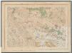
Kanton Zürich: Staats-, Gemeinde- und Genossenschaftswaldungen: Blatt 7: Gegend bei der Lägern, bei Boppelsen, Dällikon, Regensdorf, Schlieren und Urdorf; Situationsplan
1 : 25000 Auf Ausgangskarten angebrachte farbige Eintragungen und Einzeichnungen. Ohne Erstellungsdatumsangabe. Ausgangskarten: Blätter 39 (Baden), 42 (Dielsdorf), 155 (Rohrdorf) und 158 (Schlieren) des Topographischen Atlasses der Schweiz (Siegfried-Karte). Hartmann, Karl, Forstadjunkt im Zürcher Oberforstamt, von Aarau, in Unterstrass
Dampfomnibusbahn am rechten Limmatufer, I. Sektion: Zürich-Höngg; Übersichtsplan
1 : 100000 Eidgenössisches Stabsbüro
[Gegend zwischen Limmat und Glatt]
1 : 45000 1 Karte Lith. Inst. v. C. Gust. Wenng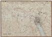
Kanton Zürich: Wassernutzungskataster; Übersichtskarten: Bezirk Zürich
1 : 25000 Ausgangskarten (zusammengesetzt): Ausschnitte der Blätter 39 (Baden), 42 (Dielsdorf), 43 (Kloten), 155 (Rohrdorf), 158 (Schlieren), 159 (Schwamendingen), 160 (Birmensdorf), 161 (Zürich) und 175 (Thalwil) des Topographischen Atlasses der Schweiz (Siegfried-Karte). Ausgangskarten Leitung: Siegfried, Hermann (1819-1879), Topograf und Kartograf, von Zofingen AG; Eidgenössisches Topographisches Bureau, in Bern
Geometrischer Grund-Riss aller Marken der Gerichts-Herrlikeit dess Gottshauses Wettingen
1 : 30000 1 Karte ex Joh. Conr. Gygeri tabula majore delineavit et hanc in formam traduxit P. Eugenius Speth ; Joh. Meyer chalco-graphus sculpsit
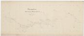
Der under Theil des Freyenamts
1 Manuskriptkarte : 40 x 52 cm Steiger; Riediger s.n.
Geometrischer Grund-riss aller Marcken der Gerichts-Herligkeit dess Gottshauss Wettingen
1 : 45000 1 Karte F. Joseph M. Maristellanus delineavit ; Johannes Meyer aeri incidit
Plan der Gegend von Zürich
1 : 31800 1 Karte gezeichnet von [Johannes] Wieland ; lith. von Sixtus in Basel
Hans Konrad Gyger's Züricher-Cantons-Carte 1667
1 : 32000 1 Karte in 56 Teilen Hans Konrad Gyger
Gewässergebiete des Kantons Zürich; Situationspläne: Affoltern bei Zürich, Boppelsen, Buchs, Dällikon, Dänikon, Dietlikon, Dübendorf, Geroldswil, Höngg, Hüttikon, Kloten, Niederhasli, Oberengstringen, Oetwil an der Limmat, Oerlikon, Opfikon, Otelfingen, Regensdorf, Rieden, Rümlang, Schwamendingen, Seebach, Unterengstringen, Wallisellen, Wangen, Weinin
1 : 2500 Mit Gemeindenummerierung. Ohne Datumsangabe.
Grenzen der Gerichtsherrschaft des Klosters Wettingen in der Grafschaft Baden; Übersichtsplan
1 : 30000 Originaltitel: Geometrischer Grund-Riss aller Marken der Gerichts-Herrlikeit dess Gottshauses Wettingen: Auss bewehrten Documentis dess Archivs aussgezogen An. 1657 und von H. Abbt Udalrico II. in dise Form eingericht, An. 1693. Erstellt auf der Grundlage eines in den 1650er und 1660er Jahren von Hans Conrad Gyger, andere Schreibweisen: Geiger, Geyger, (1599-1674), Kartograf, Ingenieur und Amtmann des Amts Kappelerhof, von Zürich, verfertigten Übersichtsplans. Zeichnung: Speth, Eugenius, Ordenspriester Stich: Meyer, Johannes, Kupferstecher
[Gegend zwischen Limmat und Glatt]
1 : 45000 1 Karte Lith. Inst. v. C. Gust. Wenng
Dietikon
1 : 25000 1 Karte [Lithographie: Josef Graf]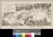
Carte topographique d'une partie du cours de la Limmat
1 : 42400 1 Karte dessiné sous la direction du chef de brigade d'artillerie Dedon; gravé par Tardieu l'ainé
Regensberg
1 : 25000 1 Karte [Lithographie: Josef Graf]