Maps of Asia

Orbis Typus Universalis Iuxta Hydrographorum Traditionem [Karte], in: Claudii Ptolemei viri Alexandrini mathematice discipline philosophi doctissimi geographie opus [...], S. 230.
1 Karte aus Atlas Waldseemüller, Martin [und Ptolemaeus, Claudius] Übelin, Georg
Übersichts-Karte für die wichtigsten Culturpflanzen der Erde, mit Angabe ihres Vaterlandes und ihrer geographischen Verbreitung
Atlas der Pflanzengeographie über alle Theile der Erde Rudolphi, Ludwig Verlag der Nicolaischen Buchhandlung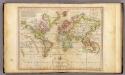
The World on Mercator's Projection.
1 : 135000000 Melish, John
Planiglob zur Übersicht der Geographischen Verbreitung der vornehmsten Krankheiten, denen der Mensch auf der ganzen Erde ausgesetzt ist
Zweiter Band, enthaltend in vier Abtheilungen die Vertheilung der Organismen: 5. Pflanzen-Geographie, 6. Thier-Geographie, 7. Anthropographie, 8. Ethnographie Humboldt, Alexander von Verlag von Justus Perthes
World On Mercator's Projection.
1 : 150000000 Finley, Anthony
Plain map (World)
1 : 100000000 Wauthier, J. M.
Mean Annual Temperature of the Earth's Surface.
1 : 110000000 Hughes, William
Isothermal, winds; Religions Europe.
Andree, Richard; Times (London, England)
Isothermen- u. Windkarte; Religionskarte v. Europa.
Andree, Richard
Planiglob zur Ubersicht der Verbreitung der Deutschen
1 : 140000000 Berghaus, Heinrich
Planiglob Zur Ubersicht der Geographischen Verbreitung Der Vornehmsten Krankheiten.
1 : 140000000 Berghaus, Heinrich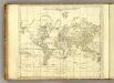
World.
1 : 94000000 Jefferys, Thomas
World (blank)
1 : 94000000 Jefferys, Thomas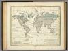
Alexander von Humboldt's System Der Isotherm-Kurven.
1 : 110000000 Humboldt, Alexander von, 1769-1859
Geographische Verbreitung und Vertheilung der Raubthiere, Carnivora.
1 : 115000000 Berghaus, Heinrich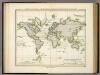
Ubersicht Der Mittleren Barometerstande Am Meere Und Der Oscillationen.
1 : 110000000 Berghaus, Heinrich
Geographische Verbreitung und Vertheilung der Raubthiere, Carnivora
Zweiter Band, enthaltend in vier Abtheilungen die Vertheilung der Organismen: 5. Pflanzen-Geographie, 6. Thier-Geographie, 7. Anthropographie, 8. Ethnographie Humboldt, Alexander von Verlag von Justus Perthes
Chart of the world on Mercators projection : exhibiting all the new discoveries to the present time, with the tracks of the most distinguished navigators since the year 1700 carefully collected from the best charts, maps, voyages, &c. extant and regulated from the accurate astronomical observations made in three voyages performed under the command of Captn. James Cook in the years 1768, 69, 70, 71, 72, 73, 74, 75, 76, 77, 78, 79 & 80
1 : 20000000 Arrowsmith, Aaron, 1750-1823 A. Arrowsmith
Map Of The World.
1 : 20000000 Stanford, Edward
Planiglob in Mercators Projection, zur Uebersicht der Erdfläche und der Seereisen
Hand-Atlas über alle Theile der Erde nach dem neuesten Zustande und über das Weltgebäude Stieler, Adolf bei Justus Perthes
Typus Orbis A Ptol. Descriptus [Karte], in: Geographia universalis vetus et nova complectens Claudii Ptolemaei Alexandrini enarrationis libros VIII, S. 219.
1 Karte aus Atlas Münster, Sebastian [und Ptolemaeus, Claudius]
World Mercators proj.
1 : 70000000 Johnston, Alexander Keith, 1804-1871
World.
1 : 45000000 Robert Laurie & James Whittle
World, Mercator's projection.
1 : 82000000 Hall, S. (Sidney)
The World on Mercator's projection.
1 : 40000000 Pinkerton, John, 1758-1826
[Recto], uit: Noord- en Zuid-Amerika / [aardrijksk. medew. G.J. de Vries]
1 : 76000000 titelvariant: Landen van Amerika met de hoofdsteden; Amerika; Annotatie: Titel boven krt.: Landen van Amerika met de hoofdsteden; Titel op keerzijde: Amerika; Verso: statistische gegevens betreffende de voornaamste staatkundige gebieden; Annotatie geografische gegevens: Inzet: Aruba; Curaçao; Willemstad; Suriname Gerben Johannes de Vries 1886-1968 Sneek : Tonnema
An accurate chart of the world with the new discoveries : also a view of the general &c coasting trade winds, monsoons or shifting trade winds & the variations of the compass ; from the latest and best authorities
1 : 90000000 Kitchin, Thomas, d. 1784 s.n.
Humboldt's System of Isothermal Lines
The physical atlas Johnston, Alexander Keith William Blackwood & Sons
The World
A new general atlas of modern geography, consisting of a complete collection of maps of the four quarters of the globe Wyld, James James Wyld
![Orbis Typus Universalis Iuxta Hydrographorum Traditionem [Karte], in: Claudii Ptolemei viri Alexandrini mathematice discipline philosophi doctissimi geographie opus [...], S. 230.](https://images-2.georeferencer.com/images/iiif/739084629348/full/,300/0/native.jpg)

