Maps of Padova

Patavini Territorii Corographia [Karte], in: Theatrum orbis terrarum, S. 305.
1 Karte aus Atlas Ortelius, Abraham Vrients, Jan Baptista
Patavini Territorii Corographia [Karte], in: Theatrum orbis terrarum, S. 210.
1 Karte aus Atlas Ortelius, Abraham
Territorio Padouano [Karte], in: Le théâtre du monde, ou, Nouvel atlas contenant les chartes et descriptions de tous les païs de la terre, Bd. 3, S. 123.
1 Karte aus Atlas Blaeu, Willem Janszoon und Blaeu, Joan Blaeu, Willem Janszoon
Territorio Padovano [Karte], in: Novus Atlas, das ist, Weltbeschreibung, Bd. 3, S. 127.
1 Karte aus Atlas Blaeu, Joan Blaeu, Willem Janszoon
Territorio Padovano [Karte], in: Theatrum orbis terrarum, sive, Atlas novus, Bd. 3, S. 107.
1 Karte aus Atlas Blaeu, Joan Blaeu, Willem Janszoon
TERRITORIO | PADOVANO
[Amsterdam : Joan Blaeu]
Territorio Padovano. [Karte], in: Novus atlas absolutissimus, Bd. 5, S. 47.
1 Karte aus Atlas Janssonius Offizin

Territorio Padovano. [Karte], in: Gerardi Mercatoris et I. Hondii Newer Atlas, oder, Grosses Weltbuch, Bd. 2, S. 255.
1 Karte aus Atlas Mercator, Gerhard und Hondius, Jodocus Jansson, Jan
Territorio Padovano
1 : 247000 Padova (Itálie : provincie) Hondius, Henricus apud Henricum Hondium
Le Padouan et le Polsin de Rovigo de la Republique de Venise
1 : 450000 Mollova mapová sbírka Nolin, Jean-Baptiste Nolin, Jean Baptiste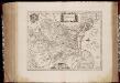
Territorio Padovano
1 : 256000 Annotatie: Kaart uitgegeven in de periode tussen 1644-1658; Origineel is Blad 159 in atlas factice; Annotatie geografische gegevens: Schaalstokken op kaart: 8 Milliaria Italica (=5,8 cm), en: 2 Milliaria Germanica communia (=5,8 cm) Amstelodami : Apud Ioannem Ianssonium
Territorio Padovano
1 : 242600 Padova (Itálie : provincie) Janssonius, Johannes apud Ioannem Ianßonium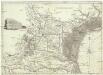
Il Padovano e la parte media del Dogado
1 : 164000 Benátsko (Itálie) Scattaglia, Pietro Pietro Scattaglia
Carte nouvelle du Padouan, et le Polsin de Rovigo, de la République de Venise : levée par ordre exprès à l'usage des armées en Italie, où sont exactement marqués les grands chemins, les routes des imperiaux &c
1 : 220000 par le Sr. Sanson A Amsterdam : chez Pierre Mortier
Mappa del Padovano del Polesine di Rovigo del Dogado della parte meridionale del Vicento del Trevigiano e della parte settentrionale del Ferrarese
1 : 145000 Benátsko (Itálie) Valle, Giovanni Viani, Mattio Mattio Viani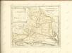
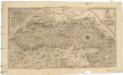
Golfo di Venetia
1 : 2830000 Benátky-oblast (Itálie) Forlani, Paolo Badoero, Piero Paolo Forlani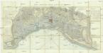
Mappa generale delle lagune di Venezia
1 : 58800 Benátky-oblast (Itálie) Gombatti, B. Moretti, Dionisio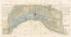
Mappa generale delle lagune di Venezia
1 : 60000 Benátky-oblast (Itálie) Gombatti, B. Moretti, Dionisio
Veronae Vicentiae et Patavii ditiones
1 Karte : Kupferdruck ; 35 x 47 cm Mercator s.n.
Veronae Vicentiae et Patavii ditiones
1 Karte : Kupferdruck ; 35 x 48 cm Mercator s.n.
Patavini territorii corographia
1 Karte : Kupferdruck ; 31 x 22 cm Gastaldi; Ortelius s.n.
Patavini territorii corographia
1 Karte : Kupferdruck ; 31 x 22 cm Gastaldi; Ortelius s.n.

Diocesi Padovana con tutta la sua Estensione ne Vicini Territori
1 : 150000 Mollova mapová sbírka Clarici, Paolo Bartolommeo
Cours du Po, Ferrare-Venise.
1 : 250000 Placide de Sainte Helene, Father
Carta topografica della Laguna Veneta
1 : 74000 Benátky-oblast (Itálie) Tonegutti, Giovanni Battista Paleocapa, Pietro Gio. Batta. Tonegutti
Polesine di Rovigo

![Patavini Territorii Corographia [Karte], in: Theatrum orbis terrarum, S. 305.](https://images-2.georeferencer.com/images/iiif/366298977174/full/,300/0/native.jpg)

