Maps of Southern Finland

Oost-Zee Streckende van Dageroort tot Wyborgh [Karte in 2 Teilen], in: De Nieuwe Groote Vermeerderde Zee-Atlas ofte Water-Werelt, S. 27.
1 Karte aus Atlas Doncker, Hendrick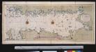
Nieuwe afteekening van de Finlandse Golff
Gulf of Finland Abraham Maas Gerard van Keulen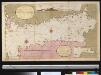
Afteekening van t agterste gedeelte van de Oost Zee van t eijlant Dago tot Schansternij
Gulf of Finland Gerard van Keulen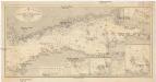
Ostsee
1 : 400000 Baltské moře Reichs-Marine-Amt
Afteekening van de Oostzee of Oost Finsche Boodem vertoonende de vaart van Revel tot St. Petersburgh int groot
Gulf of Finland Gerard van Keulen
Trigonometrisk grunnlag, vedlegg 65, 10-13: Grunnlagspunkter for Struves meridianbue fra Finnland og Estland
1 : 200000 de Struve
Kronstadt, Wiborg, Wesenberg
1 : 750000 Kronštadt (Rusko) K. u. k. Militärgeographisches Institut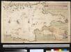
Afteekening van de Finsche Boodem in de Ost Zee of vaarweg van 't Hoogland tot voor St. Petersborgh
Gulf of Finland Gerard van Keulen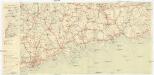
Finnland Straßenkarte
1 : 200000 Finsko Gen St d H Abt f Kr Kart u Verm W IV Mil Geo
Ostsee
1 : 150000 Baltské moře Reichs-Marine-Amt
Narva
1 : 200000 KV. ST. Topo-Hüdrograafia Osakonna Väljaanne
Kaart van de Zweedse en Russische krygs-verrigtingen in Finland A° 1788
1 : 155000 P. v. Eeusom jnr. sculp.
Ostsee
1 : 50000 Baltské moře Reichs-Marine-Amt
Afteekening van de rivier van Narva
Estonia Gerard van Keulen
Schema k dějstvījam u Ganguta v ījulě 1714 g.
Finnland Hanko Nordischer Krieg <1700-1721>
Ostsee
1 : 50000 Baltské moře Reichs-Marine-Amt
Proryv galernago flota 26 ījulja 1714 goda.
Ostsee Nordischer Krieg <1700-1721> Seeschlacht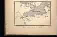
Proryv galernago flota 27 ījulja 1714 goda.
Ostsee Nordischer Krieg <1700-1721> Seeschlacht
Kr. Sveaborg i okrestnosti putej vokrug Gel'singforsa
Finnland Suomenlinna Russisch-Schwedischer Krieg <1808-1809>
Kaart van de krygs-verrigtingen der Zweeden en Russen in Finland A°. 1789
1 : 123000 door Roos
Sraženīe pod Narvoj 19 nojabrja 1700 g.
Estland Narva Nordischer Krieg <1700-1721>
Plan de Narva assiégé par 80000 Moscovites qui furent attaqués dans leurs lignes par Charles Xll
1 Karte : Kupferdruck ; 23 x 32 cm Aa, Pieter van der [Pieter van der Aa]
Nieuwe kaart van de Finnissche Golf benevens de omliggende provintien : naar de beste kaarten en sterrekundige waarnemingen geteekend in 't Konigl. Landmeeters Comtoir te Stockholm
1 : 1200000 C. van Baarsel sculp. te Amsterdam : bij J. Covens en Zoon
Sinus Finnici delineatio geographica / ex quam plurimis subsidiis novissimis stereographice tradita
1 : 1000000 1 Karte auf 2 Blatt : Kupferdruck ; 44 x 81 cm Mayer, Tobias [Homännische Erben]
Von Riga nach St. Petersburg
1 : 2600000 Baltikum
Ost-See Provinzen.
1 : 1370000 Grassl, J. (Joseph)

DVCATVVM LIVONIAE et CVRLANDIAE cum vicinis Insulis Nova Exhibitio Geographica
1 : 917000 Estonsko Homann, Johann Baptist Ioh. Baptista Homanno
Dvcatvvm Livoniae et Cvrlandiae cum vicinis insulis nova exhibitio geographica
1 : 895000 Estonsko Homann, Johann Baptist Ioh. Baptista Homanno
![Oost-Zee Streckende van Dageroort tot Wyborgh [Karte in 2 Teilen], in: De Nieuwe Groote Vermeerderde Zee-Atlas ofte Water-Werelt, S. 27.](https://images-2.georeferencer.com/images/iiif/949983507328/full/,300/0/native.jpg)

