Maps of Tyrol

Comitatus Tirolensis. [Karte], in: Novus atlas absolutissimus, Bd. 2, S. 220.
1 Karte aus Atlas Janssonius Offizin
Gefürstete Graffschafft Tyrol im Oesterreichischen Creiße Teutschlandes mit ihren Gräntzen
Weigel, Johann Christoph
Karte der gefürsteten Grafschaft Tyrol nach den vortrefflichen Karten des Peter Anich und Blasius Huber
Tyrolsko (Rakousko) Kipferling, Karl Joseph Anich, Peter im Verlage des Kunst und Industrie Comptoirs
Karte der gefürsteten Grafschaft Tyrol
Tyrolsko (Rakousko) Kipferling, Karl Joseph Anich, Peter im Verlage des Kunst und Industrie Comptoirs
Tyrol, Vorarlberg, Liechtenstein.
1 : 800000 Flemming, Carl
Die gefürstete Grafschaft Tyrol nebst Vorarlberg und dem Fürstenthum Liechtenstein nach der, vom Kaiserl. Oesterreichischen General Quartiermeisterstabe herausgegebenen Specialkarte
Weiland, [Karl Ferdinand] Geograph. Inst.
Die gefürstete Grafschaft Tyrol nebst Vorarlberg und dem Fürstenthum Liechtenstein : nach der vom Kaiserlich Oesterreichischen General Quartiermeisterstabe herausgegebene Specialkarte
Weiland, [Karl Ferdinand] Verlag d. Geograph. Inst.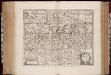
Comitatus Tirolensis
1 : 530000 Annotatie: Origineel is Blad 122 in atlas factice; In rechterbovenhoek: IV; Annotatie geografische gegevens: Schaalstokken linksonder: Milliaria Germanica communia, en Milliaria Italica Moses Pitt ca. 1654-1696; Stephanus Swart; Johannes Janssonius van Waesberge -1681? [Oxford] : [Moses Pitt, Steven Swart, Johannes Janssonius van Waesbergen]
Charte von Tirol und Vorarlberg
1 : 520000 nach den besten Hülfsquellen und neuesten astronomischen Orts-Bestimmungen entworfen von F. W. Streit nach den neuesten äusseren Grenzen berichtiget 1817 Weimar : Verlag des Geograph. Instituts
Comitatus Tyrolis tabula
1 : 1040000 Tyrolsko (Rakousko) Granelli, Carlo Engelbrecht, Christian Pfeffel et Engelbrecht
Wandkarte von Tirol und Vorarlberg : für Volks- und Mittelschulen
Kaler, G. v. Wagner
Karte von der gefürsteten Grafschaft Tyrol
1 Karte : Kupferdruck ; 47 x 56 cm Walch zufinden in Kunst u. Landkarten Verlag des I. Walch
Karte von der gefürsteten Grafschaft Tyrol
1 Karte : Kupferdruck ; 46 x 55 cm Walch zufinden in Kunst u. Landkarten Verlag des I. Walch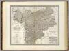
Tyrol, Voralberg, Liechtenstein.
1 : 500000 Weiland, C. F. (Carl Ferdinand), d. 1847
Tyrol, Voralberg, Lichtenstein.
1 : 810000 Radefeld, Carl Christian Franz, 1788-1874
Die gefuerstete Grafschaft Tyrol nebst Vorarlberg und dem Fürstenthum Liechtenstein
1 : 500000 Innsbruck (Rakousko : oblast) Weiland, Karl Ferdinand im Verlage des Geograph. Instituts
Die gefuerstete Grafschaft Tyrol nebst Vorarlberg und dem Fürstenthum Liechtenstein
1 : 500000 Innsbruck-oblast (Rakousko) Weiland, Karl Ferdinand Mädel im Verlage des Geograph. Instituts
Die gefürstete Grafschaft Tyrol nebst Vorarlberg und dem Fürstenthum Liechtenstein
1 : 500000 Lichtenštejnsko Weiland, Karl Ferdinand Geograph. Institut
Generalkarte von Tirol und Vorarlberg
Steinhauser, Anton
Il Tirolo con li Vescovati di Trento e Brixen e la Città Imperiale di Costanza che sono in protezione de Conti del Tirolo, le Contee di Bregentz e Pludentz che sono incorporate allo stesso e li Feudi e Dependenze che li sono soggetti
Cantelli, Giacomo Giacomo de Rossi
Reise-Karte von Tyrol u. Vorarlberg mit den angränzenden Ländertheilen
1 : 600000 Salcburské Alpy (Rakousko) Mayr, Georg Obernetter, Johann Verlag der liter. artistischen Anstalt

Die gefürstete Grafschaft Tirol nebst Vorarlberg, und dem Fürstenthum Lichtenstein
Lichtenštejnsko Marco Berra
Status Tirolensis; qui Complectitur Ipsissimum eiusdem Nominis, et Anexum ei Brigantinae Comitatus; Simul atque Tridentini Dioecesin : Tabula Planè Nova
Valk, Gerard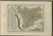

Comitatus Principalis Tirolis in quo Episc. Tridentinus et Brixensis, Comitatus Brigantinus, Feldkirchiae, Sonnebergae et Pludentii
Homann, Johann Baptist Homann
Comitatus Principalis Tirolis in quo Episc. Tridentinus et Brixensis, Comitatus Brigantinus, Feldkirchiae, Sonnebergae et Pludentii
Homann, Johann Baptist Homann
Die gefürstete Grafschaft Tirol mit Vorarlberg und das Fürstenthum Liechtenstein
1 : 550000 Lichtenštejnsko Gräf, C. Geyer, V. Geographisches Institut
Tyrolis comitatus
1 : 1000000 Mollova mapová sbírka Gumpp, Johann Martin Gumpp, Johann Baptist
![Comitatus Tirolensis. [Karte], in: Novus atlas absolutissimus, Bd. 2, S. 220.](https://images-2.georeferencer.com/images/iiif/268356887412/full/,300/0/native.jpg)

