Maps of Limburg

Dioecesis Leodiensis Accurata Tabula. [Karte], in: Novus atlas absolutissimus, Bd. 2, S. 156.
1 Karte aus Atlas Janssonius Offizin
Dioecesis Leodiensis accurata tabula
1 : 165000 Belgie jižní Hondius, Henricus H. Hondius
Dioecesis Leodiensis accurata tabula
1 : 165000 Belgie jižní Hondius, Henricus sumptibus Henrici Hondii
Carte Contenant le Duche de Limbourg et Partie du Dioecese de Liege dediée A Son Altesse Electorale de Baviere
1 : 140000 Mollova mapová sbírka Medtman, Matthias van Husson, Pierre
Leodiensis Dioecesis
1 : 390000 Mollova mapová sbírka Blaeu, Willem Janszoon Blaeu, Joan I.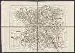
Dioecesis Leodiensis Accurata Tabula. [Karte], in: Gerardi Mercatoris et I. Hondii Newer Atlas, oder, Grosses Weltbuch, Bd. 1, S. 208.
1 Karte aus Atlas Mercator, Gerhard und Hondius, Jodocus Jansson, Jan
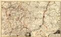
Maastricht 83, uit: [W. Liebenow's Special-Karte von Mittel-Europa]
1 : 300000 titelvariant: W. Liebenow's Mittel-Europa; Annotatie: Titel boven de bladen: W. Liebenow's Mittel-Europa Johannes Wilhelm Liebenow 1822-1897 Hannover : Hermann Oppermann
Maastricht 83, uit: Special-Karte von Mittel-Europa / nach amtlichen Quellen bearbeitet von W. Liebenow
1 : 300000 titelvariant: W. Liebenow's Mittel-Europa; Annotatie: Titel boven de bladen: W. Liebenow's Mittel-Europa Johannes Wilhelm Liebenow 1822-1897 Frankfurt a. M. : Ludwig Ravenstein
Dioecesis Leodiensis Accurata Tabula
1 : 170000 Mollova mapová sbírka Valk, Gerhard Allard, Carel
Dioecesis Leodiensis Accurata Tabula
1 : 170000 Mollova mapová sbírka Valk, Gerhard Schenk, Peter I

Le Limbourg, ou sont Le Duché De Limbourg Le Comté De Dalem; Les Seigneuries De Fauquemont Et De Rolduc [Karte], in: Atlas nouveau, contenant toutes les parties du monde [...], Bd. 2, S. 36.
1 Karte aus Atlas Sanson, Nicolas Jaillot, Alexis Hubert und Mortier, Pieter
Ducatus Limburgum [Karte], in: Novus atlas absolutissimus, Bd. 3, S. 67.
1 Karte aus Atlas Janssonius Offizin
Ducatus Limburgum [Karte], in: Theatrum orbis terrarum, sive, Atlas novus, Bd. 1, S. 357.
1 Karte aus Atlas Blaeu, Joan Blaeu, Willem Janszoon
Ducatus Limburgum [Karte], in: Novus Atlas, das ist, Weltbeschreibung, Bd. 1, S. 336.
1 Karte aus Atlas Blaeu, Joan Blaeu, Willem Janszoon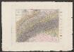
Ducatus Limburgum [Karte], in: Le théâtre du monde, ou, Nouvel atlas contenant les chartes et descriptions de tous les païs de la terre, Bd. 1, S. 363.
1 Karte aus Atlas Blaeu, Willem Janszoon und Blaeu, Joan Blaeu, Willem Janszoon
Le Limbourg ou sont le Duché de Limbourg, le Comté de Dalem, les Seigneuries de Fauquemont et de Rolduc : dressé sur les mémoires le pl[u]s recents
1 : 185000 par le Sr. Sanson. A Amsterdam : chez R. & J. Ottens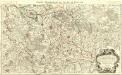
Le Duché de Brabant :
1 : 146000 Mollova mapová sbírka Jaillot, Alexis-Hubert
DVCATVS | LIMBVRGVM
Auctore | ÆGIDIO MARTINI. Amsterdami | Apud Guiljelmum et Joannem Blaeu
DVCATVS | LIMBVRGVM
Auctore | ÆGIDIO MARTINI. Amsterdami | Apud Guiljelmum et Joannem Blaeu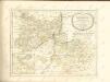

Plan de la Province de Liège.
1 : 80000 [S.l.] : [s.n.]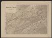
Ducatus Limburg. [Karte], in: Gerardi Mercatoris et I. Hondii Newer Atlas, oder, Grosses Weltbuch, Bd. 1, S. 401.
1 Karte aus Atlas Mercator, Gerhard und Hondius, Jodocus Jansson, Jan

Limburgi Ducatus et Comitatus Valckenburgi Nova Descriptio [Karte], in: Novus atlas absolutissimus, Bd. 3, S. 70.
1 Karte aus Atlas Janssonius Offizin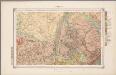
27. Limburg, uit: Geologische kaart van Nederland / door W.C.H. Staring ; bew. aan de Topographische Inrichting
1 : 200000 Winand Carel Hugo Staring 1808-1877; Topographische Inrichting, 's-Gravenhage 's-Gravenhage : Belinfante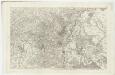
IX ; 2.L., uit: Carte chorographique des Pays-Bas Autrichiens / ... par le Comte de Ferraris ; gravée par L.A. Dupuis
1 : 86400 Annotatie: Bladen linksboven genummerd met Romeinse cijfers, rechtsboven met een cijfer en een letter; Met opdracht aan keizer Joseph II (bl.XVI); Met plattegrond van Brussel (bl. XXI), overzichtskaart (bl. XXII) en bladwijzer (bl. XXIII); Annotatie geografische gegevens: Schaalstokken: Echelle de Toises ou de Lieues communes de France; Echelle de Verges ou de Lieues de Brabant; Echelle de Milles d'Allemagne (bl. XVII); Echelle de Mètres; In de hoeken lengte- en breedtematen T.M.e en T.P.e Joseph-Jean François Ferraris Comte de 1726-1814; L.A. Dupuis [S.l. : s.n.]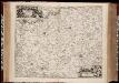
Limburgi Ducatus et Comitatus Valckenburgi nova descriptio / per N. Visscher
1 : 110000 Annotatie: Origineel is Blad 38 in atlas factice; Annotatie geografische gegevens: Noordwest boven; Met 2 schaalstokken Nicolaes Jansz Visscher sr 1618-1679 [Amsterdam : N. Visscher]
![Dioecesis Leodiensis Accurata Tabula. [Karte], in: Novus atlas absolutissimus, Bd. 2, S. 156.](https://images-2.georeferencer.com/images/iiif/438426031872/full/,300/0/native.jpg)

