Maps of Hesse

Nova Et Accurata Moguntini Archiepiscopatus delineatio. [Karte], in: Novus atlas absolutissimus, Bd. 2, S. 153.
1 Karte aus Atlas Janssonius Offizin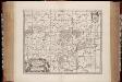
Nova et accurata Moguntini archiepiscopatus delineatio / [Jan Jansson]
1 : 620000 Annotatie: Origineel is Blad 106 in atlas factice; Annotatie geografische gegevens: Schaalstok op de kaart: Milliaria Germanica communia; Oosten boven; Rechtsboven naast wapen: XXXVI Jan Jansson -1655 [Amstelodami] : [Joanni Janssonii haeredes]
Charte von den Kurfürstlich, Grossherzoglich und Landgraeflich Hessischen Ländern, von dem Herzogthume Nassau, den Fürstenthume Waldeck, und dem Gebiethe der freien Stadt Frankfurt
1 : 1625000 entworfen und gezeichnet von F. W. Streit Nürnberg : Campe
Staaten im hessischen Raum 1817
Hessen-Darmstadt, Staat Nassau Kunz, Andreas ; Treiling, Thomas ; Moeschl, Joachim
Straßen in den Hessischen Staaten 1848
Hessen Straßennetz Kunz, Andreas ; Treiling, Thomas
Staaten im hessischen Raum 1867
Hessen-Darmstadt, Staat Nassau Kunz, Andreas ; Treiling, Thomas ; Moeschl, Joachim
Länder im hessischen Raum 1947
Hessen Kunz, Andreas ; Treiling, Thomas ; Moeschl, Joachim
Staaten im hessischen Raum 1929
Hessen Kunz, Andreas ; Treiling, Thomas ; Moeschl, Joachim
Hessen, Nassau, Waldeck 1820
Hessen, Staat Waldeck Hundt, Michael
Hessen, Nassau, Waldeck 1814
Hessen, Staat Waldeck Hundt, Michael
Hessen, Nassau, Waldeck 1812
Hessen, Staat Waldeck Hundt, Michael
Länder im hessischen Raum 1946
Hessen Kunz, Andreas ; Treiling, Thomas ; Moeschl, Joachim
Hessen, Nassau, Waldeck 1848
Hessen-Darmstadt, Hessen-Nassau Kunz, Andreas ; Moeschl, Joachim Robert
Hessen, Nassau, Waldeck 1871
Hessen-Darmstadt, Hessen-Nassau Kunz, Andreas ; Moeschl, Joachim Robert
Hessen, Nassau, Waldeck 1867
Hessen-Darmstadt, Hessen-Nassau Kunz, Andreas ; Moeschl, Joachim Robert
Charte von den Königlich Preusischen Provinzen Westphalen, Cleve-Berg und Niederrhein dem Kurfürstenthume Hessen, Grosherzogthume Hessen, dem Herzogth. Nassau, Fürstenth. Waldeck und dem Gebiete der freien Stadt Frankfurt
1 : 1080000 Dolní Porýní (Německo) Weiland, Karl Ferdinand im Verlage des Geograph. Instituts
Landgraviatus Hassiae Darmstadiensis Rhenofeldensis cum adjacentibus Regionibus ut Langraviatuum Thuringiae Ducatuum Westfaliae Brunwicensis Comitatuum Hanoviae Nassoviae cum Abatia Vuldense e[t] c[e]t[era] Accuratissima Discriptio
1 : 550000 Danckerts, Theodor Danckerts
Grossherzogthum Hessen.
1 : 640000 Flemming, Carl
Hassiae Desciptio [Karte], in: Theatrum orbis terrarum, S. 226.
1 Karte aus Atlas Ortelius, Abraham Vrients, Jan Baptista
Estats De la Succeßion de Cleves et Iuliers
1 : 860000 Mollova mapová sbírka Sanson, Nicolas Cordier, Robert Sanson, Nicolas
Hassiae Desciptio [Karte], in: Theatrum orbis terrarum, S. 134.
1 Karte aus Atlas Ortelius, Abraham
Upper, Lower Rhine circles.
1 : 700000 Cary, John, ca. 1754-1835
Upper, Lower Rhine.
1 : 720000 Lizars, Daniel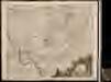
Landgraviatus Hassiae Darmstadiensis Rhenofeldensis cum adjacentibus regionibus ut landgraviatuum Thuringiae ducatuum Westfaliae Brunswicensis comitatuum Hanoviae Nassoviae cum abatia Vuldense ect: accuratissima discriptio
1 : 550000 1 Karte : Kupferdruck ; 48 x 54 cm Danckerts, Theodorus [Danckerts]
Hassia Lantgraviatus Tam Superior Casselanensis quam Inferior Darmstadina
1 : 410000 Mollova mapová sbírka Valk, Gerhard

S. R. I. Pars Septentrionalior Superioris Circuli Rhenani

Superior et inferior Hassiæ landgraviatus
1 Karte : Kupferdruck ; 47 x 54 cm Seutter; Lotter Matthäus Seutter
Mappa Circuli Rhenani Superioris
1 : 460000 Mollova mapová sbírka Seutter, Matthäus Seutter, Matthäus
S. R. I. Circulus Rhenanus Superior
1 : 470000 Mollova mapová sbírka Homann, Johann Baptist Homann, Johann Baptista - dědici
S. R. I. Pars Septentrionalior Superioris Circuli Rhenani
1 : 460000 Mollova mapová sbírka Wit, Frederik de Covens, Johannes I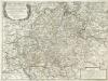
Parte Inferiore Del Circolo Dell' Alto Reno
Mollova mapová sbírka Cantelli, Giacomo Messis, Francesco Donia De Rossi, Giovanni Giacomo
![Nova Et Accurata Moguntini Archiepiscopatus delineatio. [Karte], in: Novus atlas absolutissimus, Bd. 2, S. 153.](https://images-2.georeferencer.com/images/iiif/996929489095/full/,300/0/native.jpg)

