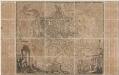
Maps of Viterbo

Toscana Inferiore, Detta Anticamente Tuscia Suburbicaria. [Karte], in: Novus atlas absolutissimus, Bd. 5, S. 125.
1 Karte aus Atlas Janssonius Offizin
PATRIMONIO DI S. PIETRO
1 : 190000 Lazio (Itálie) Ameti, Giacomo Filippo edentibus Homannianis Heredibus
Patrimonio di S. Pietro, con le sue piu conspicue Strade Antiche e Modena e principali casali e Tenute di esso descritto da Giacomo Filippi Ameti Romano, e data in luce da Domenico de Rossi in Roma l'Anne 1696
1 : 200000 Mollova mapová sbírka Ameti, Giacomo Filippo Homann, Johann Baptista - dědici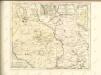

Patrimonio di S. Pietro Sabina, et Ducato di Castro
1 : 210000 Mollova mapová sbírka Magini, Giovanni Antonio Magini, Fabio
A plan of the environs of ancient Rome
1 : 412000

TERRITORIO | DI | ORVIETO.
[Amsterdam : Joan Blaeu]
Campagna di Roma
Řím-oblast (Itálie) Lotter, Tobias Conrad Pronti, Domenico presso Piale neg. di stampe
Ducatus Bracciani et Anguillariae Comitatus, Olim Sabatia. [Karte], in: Novus atlas absolutissimus, Bd. 5, S. 171.
1 Karte aus Atlas Janssonius Offizin
DVCATVS | BRACCIANVS, | olim | SABATIÆ REGIO.
[Amsterdam : Joan Blaeu]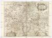
TAVOLA GENERALE DELLA PROVINCIA DI SABINA
1 : 209000 Sabina (Itálie) Cigni, Giulio Cesare Campiglia, Giovanni Domenico Gio. Domenico Campiglia
Roma e dintorni
1 : 100000 Istituto Geografico Militare (Firenze) Istituto Geografico Militare
Terretorii Romani Descrip. [Karte], in: Theatrum orbis terrarum, S. 214.
1 Karte aus Atlas Ortelius, Abraham
Territorii Romani Descrip. [Karte], in: Theatrum orbis terrarum, S. 85.
1 Karte aus Atlas Ortelius, Abraham
Terretorii Romani Descrip. [Karte], in: Theatrum orbis terrarum, S. 309.
1 Karte aus Atlas Ortelius, Abraham Vrients, Jan Baptista
Insvlae Tremitanae, olim Diomedeae dictae Isles de Diomede ou Tremitanes
Mollova mapová sbírka Blaeu, Willem Janszoon Mortier, Pierre
Città di Roma: Roma nel 1950 / Istituto Geografico Militare
Istituo Geografico Militare (Itàlia)
Eigentliche Vorstellung und Grund-Riß der Halb-Insul MonteArgentaro genant
Mollova mapová sbírka
Vrbis Romae ichnographia
1 : 5000 Nolli, Giambattista, ca. 1692-1756 Offic. Homann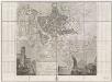
Pianta di Roma
1 : 8500000 Montiroli, Giovanni, b. 1837 Luigi Piale
Urbis Romae veteris ac modernae accurata delineatio
1 : 20040 Homann, Johann Baptist, 1663-1724 Joh. Bapt. Homannus
Novissima et accuratissima delineatio Romae veteris et novae : in viatorum usum et commoditatem excusa
1 : 20040 Aa, Pieter van der, 1659-1733 Petri Vander Aa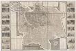
Pianta della citta di Roma : con la indicazione di tvtte le antichita e nvovi abbellimenti nell anno MDCCCXXXII
1 : 5066 Ruga, Pietro publicata a spese di Venanzio Monaldini libraio e cartolaro in Piaz.a dei Spagna no. 19, an. 1829
Pianta delle vestigia di Roma
1 : 8769 Romanis, Antonio de presso Veanzio Monaldini ... con approvazione e privilegio Pontificio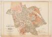
Disegno dimonstrativo del piano regolatore e di ampliamento della città di Roma : in relazione alla legge sul concorso della stato nelle spese edilizie della capitale: approvato dal consiglio comunale nella seduta del 20 Giugno 1882
1 : 8000 Martelli, A publicazione autorizzata dal Comune di Roma.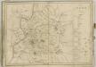
Alla Santittá di Nostro Signore Papa Benedetto XIV la nuova topografia di Roma
1 : 3000 Nolli, Giambattista, ca. 1692-1756 Giambattista Nolli
Nuova pianta di Roma Moderna
1 : 9120 Nolli, Giambattista, ca. 1692-1756 Venanzio Monaldini Libraio e Cartolaro
![Toscana Inferiore, Detta Anticamente Tuscia Suburbicaria. [Karte], in: Novus atlas absolutissimus, Bd. 5, S. 125.](https://images-2.georeferencer.com/images/iiif/677206066935/full/,300/0/native.jpg)

