Maps of Inverness

Extimae Scotiae pars Septentrionalis, in qua Provinciae Rossia, Sutherlandia, Cathenesia, et Strath-Naverniae. [Karte], in: Novus atlas absolutissimus, Bd. 8, S. 166.
1 Karte aus Atlas Janssonius Offizin
EXTIMA SCOTIÆ | SEPTENTRIONALIS ORA, | ubi Provinciæ sunt | ROSSIA, SVTHERLANDIA, CATHENESIA, | STRATH-NAVERNIÆ, | cum vicinis regiunculis quæ eis subsunt, etiamque | MORAVIA.
R. Gordonius à Strath-loch collegit et descripsit. [Amsterdam : Joan Blaeu]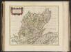
Extima Scotiae septentrionalis ora, ubi Provinciae sunt Rossia, Sutherlandia, Cathenesia, Strath-Naverniae, cum vicinis regiunculis quae eis subsunt, etiamque Moravia / R. Gordonius à Strath-loch coll
Gordon, Robert, 1580-1661 Blaeu, Joan, 1596-1673
Extima Scotiæ septentrionalis ora
1 Karte : Kupferdruck ; 40 x 50 cm Blaeu; Gordon Joan Blaeu
Ordnance Survey of Great Britain, Scotland
Ordnance Survey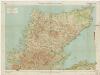
[Kaart], uit: Sutherland & Caithness
1 : 253440 titelvariant: Sutherland and Caithness; Annotatie: Titel op omslag: Sutherland and Caithness; Verso: bladoverzicht reeks Edinburgh : Bartholomew
Scotland[Motoring Map of]
London : "Geographia
Scotland / J. Ainslie, 2
1 Blatt : 68 x 58 cm Ainslie, Faden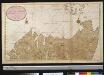
De noordelijkste kust van Schotland met alle desselfs gelegentheden
Scotland Gerard van Keulen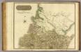
Ross, Cromarty Shires N.
1 : 190000 Craig, John
A chart of part of the North of Scotland, from Banff to Duncansby Head.
Ainslie, John, 1745-1828
A chart of part of the North of Scotland, from Banff to Duncansby Head.
Ainslie, John, 1745-1828
A chart of part of the North of Scotland, from Banff to Duncansby Head.
Ainslie, John, 1745-1828
A chart of part of the North of Scotland, from Banff to Duncansby Head.
Ainslie, John, 1745-1828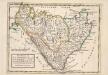
The Shires of Caithness and Sutherland. With Strath Navern which is Part of Sutherland Shire / by H. Moll.
Moll, Herman, d. 1732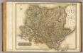
Sutherland Shire.
1 : 172000 Thomson, John
Composite: Ross, Cromarty Shires.
1 : 190000 Craig, John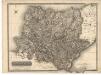
Sutherland Shire.
Thomson, John, 1777- ca. 1840 Johnson, William, fl. 1806-1840
Sutherlandshire.
Forbes, William, fl. 1790-1826
Sketch of the the county of Sutherland showing the boundaries & divisions of the earldom of Sutherland.
Anon.
Map of the county of Sutherland made on the basis of the trigonometrical survey of Scotland in the years 1831, 1832.
Burnett, Gregory, fl. 1820?-1844 Scott, William, fl. ca. 1830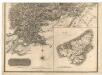
Southern Part of Ross and Cromarty Shires.
Thomson, John, 1777- ca. 1840 Craig, John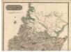
Northern Part of Ross and Cromarty Shires. Southern Part.
Thomson, John, 1777- ca. 1840 Craig, John
SOVTHERLANDIA
[Amsterdam : Joan Blaeu]
The Firth of Murry / H. Moll, sculp.
Collins, Greenvile, fl. 1669-1698 Moll, Herman, d. 1732
CATHENESIA. | CAITHNESS.
Auct. | Timotheo Pont. [Amsterdam : Joan Blaeu]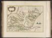
Southerlandia.
Blaeu, Joan, 1596-1673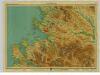
Loch Broom, Sheet 24 - Bartholomew's "Half Inch to the Mile Maps" of Scotland
1 : 126720 Topographic maps John Bartholomew & Son, Ltd John Bartholomew & Son, Ltd
Gair Loch & Loch Inver, Sheet 24 - Bartholomew's "Half Inch to the Mile Maps" of Scotland
1 : 126720 Topographic maps Bartholomew, John George John Bartholomew & Co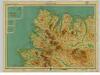
Cape Wrath, Sheet 26 - Bartholomew's "Half Inch to the Mile Maps" of Scotland
1 : 126720 Topographic maps John Bartholomew & Son, Ltd John Bartholomew & Son, Ltd
![Extimae Scotiae pars Septentrionalis, in qua Provinciae Rossia, Sutherlandia, Cathenesia, et Strath-Naverniae. [Karte], in: Novus atlas absolutissimus, Bd. 8, S. 166.](https://images-2.georeferencer.com/images/iiif/207828367075/full/,300/0/native.jpg)

