Maps of Arkhangel'sk

Russiae, vulgo Moscovia dictae, Partes Septentrionalis et Orientalis. [Karte], in: Novus Atlas, das ist, Weltbeschreibung, Bd. 1, S. 58.
1 Karte aus Atlas Blaeu, Joan Blaeu, Willem Janszoon
Rvssiæ, vulgo Moscovia dictæ, partes septentrionalis et orientalis
1 : 5100000 1 Karte : Kupferdruck ; 40 x 53 cm Jansson, Jan apud Janssonio-Waesbergios
Rvssiæ, vulgo Moscovia dictæ, partes septentrionalis et orientalis
1 : 5100000 1 Karte : Kupferdruck ; 40 x 53 cm Blaeu, Joan Apud Ioannem et Cornelium Blaeu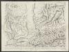
Russiae, vulgo Moscovia dictae, Partes Septentrionalis et Orientalis. [Karte], in: Theatrum orbis terrarum, sive, Atlas novus, Bd. 1, S. 74.
1 Karte aus Atlas Blaeu, Joan Blaeu, Willem Janszoon
Russiae, vulo Moscovia dictae, Partes Septentrionalis et Orientalis. [Karte], in: Le théâtre du monde, ou, Nouvel atlas contenant les chartes et descriptions de tous les païs de la terre, Bd. 1, S. 70.
1 Karte aus Atlas Blaeu, Willem Janszoon und Blaeu, Joan Blaeu, Willem Janszoon
Rvssiae, vulgo Moscovia dictae, partes septentrionalis et orientalis
1 : 5017000 Moskva-oblast (Rusko) Massa, Isaac Blaeu, Cornelius apud Ioannem et Cornelium Blaeu
RVSSIÆ, | vulgo MOSCOVIA dictæ, | Partes Septentrionalis | et Orientalis
Auctore Isaaco Maßa. Apud Ioannem et | Cornelium Blaeu.
Russiae, vulgo Moscovia dictae, Partes Septentrionalis et Orientalis. [Karte], in: Novus atlas absolutissimus, Bd. 1, S. 78.
1 Karte aus Atlas Janssonius Offizin
Europa befolkningskarta
Imperii Russici, sive Moscoviae status generalis / per F. de Witt
1 : 5800000 1 Karte : Kupferdruck ; 44 x 55 cm Witsen, Nicolaas ex officina P. Mortier
Imperii Russici, sive Moscoviae status generalis / per F. de Witt
1 : 5800000 1 Karte : Kupferdruck ; 44 x 54 cm Wit, Frederick de [Frederick de Wit]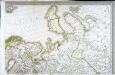
Carte d'Europe ou sont tracées les limites des empires, royaumes, et etats souverains, feuille 2
1 Blatt : 63 x 95 cm Semen etc
Administrativnaja Karta Evropejskoj časti C.C.C.P.

Novissima et accuratissima totius Russiae vulgo Moscoviae tabula
1 : 6000000 Rusko Danckerts, Justus a Iusto Danckerts
[Ost-Europa in 6 Blättern, Blatt 2]
Handatlas über alle Theile der Erde und über das Weltgebäude Stieler, Adolf Justus Perthes
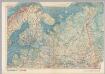
Postkarte von Nord-Russland
Rusko severozápadní Benedict, Anton im von Reillyschen Landkarten und Kunstwerke Verschleiss Komptoir
Nieuwe Kaart van Muskovie of Rusland / by Isaak Tirion ; J. Keyser fecit
1 : 10070000 1 Karte : Kupferdruck ; 27 x 33 cm Tirion, Isaak Tirion
U.S.S.R. In Europe - North. Pergamon World Atlas.
1 : 5000000 Polish Army Topography Service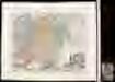
Imperium Moscovia / M. K[auffer] sc
1 : 11700000 1 Karte : Kupferdruck ; 26 x 33 cm Kauffer, Michael excudente Christoph: Weigelio
Tabula Russia vulgo Moscovia / J. Lhuilier fecit
1 : 5600000 1 Karte : Kupferdruck ; 43 x 54 cm Wit, Frederick de Gedruckt bÿ Fredrick de Wit inde Kaluer straet inde witte Paskaert
Eastern part of the northern states, including the eastern part of Sweden; European Russia, [et]c
1 Blatt : 54 x 68 cm Sayer
N. Russia in Europe.
1 : 9200000 Seaman, James V.
Carte de La Russie D'Europe.
1 : 6700000 Vivien de St Martin, L.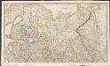
Russian Dominions
A new general atlas of modern geography, consisting of a complete collection of maps of the four quarters of the globe Wyld, James James Wyld
Russie d'Europe / par J.B. Poirson Ingénieur Géog.e
1 : 10000000 1 Karte : Kupferdruck ; 18 x 24 cm Poirson, Jean-Baptiste [Verlag nicht ermittelbar]
Carte de la Russie d'Europe / par J.B. Poirson ; gravé par Tardieu
1 : 9000000 1 Karte auf 2 Blatt : Kupferdruck ; 39 x 27 cm Poirson, Jean-Baptiste [Mentelle]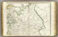
Europe 2.
1 : 3850000 Brue, Adrien Hubert, 1786-1832
Russland.
1 : 10300000 Flemming, Carl
![Russiae, vulgo Moscovia dictae, Partes Septentrionalis et Orientalis. [Karte], in: Novus Atlas, das ist, Weltbeschreibung, Bd. 1, S. 58.](https://images-2.georeferencer.com/images/iiif/055474005223/full/,300/0/native.jpg)

