Maps of Ludwigslust-Parchim

Saxonia Inferior Et Meklenborg Duc: [Karte], in: Gerardi Mercatoris et I. Hondii Newer Atlas, oder, Grosses Weltbuch, Bd. 1, S. 271.
1 Karte aus Atlas Mercator, Gerhard und Hondius, Jodocus Jansson, Jan
Saxonia Inferior Et Meklenborg Duc: [Karte], in: Gerardi Mercatoris Atlas, sive, Cosmographicae meditationes de fabrica mundi et fabricati figura, S. 370.
1 Karte aus Atlas Mercator, Gerhard Montanus, Petrus
Saxonia Inferior Et Meklenborg Duc: [Karte], in: Gerardi Mercatoris et I. Hondii Newer Atlas, oder, Grosses Weltbuch, Bd. 1, S. 224.
1 Karte aus Atlas Mercator, Gerhard und Hondius, Jodocus Jansson, Jan
Saxonia Inferior Et Meklenborg Dvc.
1 : 720000 Mollova mapová sbírka Mercator, Gerhard Hondius, Henricus
Saxonia inferior et Meklenborg dvc
1 Karte : Kupferdruck ; 33 x 43 cm Mercator; Hondius sumptibus Henrici Hondÿ
Saxonia inferior et Meklenborg dvc
1 Karte : Kupferdruck ; 33 x 43 cm Mercator s.n.
Albis. Fluvius Germaniae celebris A Fontibus Ad Ostia, Cum fluminibus ab utroque latere in illum fluentibus, descriptus. [Karte, Teil 1], in: Novus atlas absolutissimus, Bd. 2, S. 30.
1 Karte aus Atlas Janssonius Offizin
Saxonia Inferior Cum insertis & contiguis extant qq. cursus publici permutationes accurante
1 : 1200000 Mollova mapová sbírka Weigel, Christoph Kauffer, Michael Weigel, Christoph I.
Circulus Saxoniae Inferioris in omnes suos Status et Principatus accurate divisus
1 : 850000 Mollova mapová sbírka Homann, Johann Baptist Homann, Johann Baptista
Teutschlandes Niedersaechsiser Creis samt dazu gehörigen Provintzen
1 : 2900000 Mollova mapová sbírka Weigel, Johann Christoph Weigel, Christoph I.
Circulus Saxoniæ inferioris in omnes suos status et principatus accurate divisus
1 Karte : Kupferdruck ; 46 x 55 cm Homann Johann Baptist Homann
Circulus Saxoniæ inferioris in omnes suos status et principatus accurate divisus
1 Karte : Kupferdruck ; 46 x 54 cm Homann Johann Baptist Homann
Circulus Saxoniæ inferioris in omnes suos status et principatus accurate divisus
1 Karte : Kupferdruck ; 46 x 55 cm Homann Johann Baptist Homann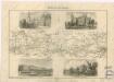
Berlin - Hamburg
Hansestädte, Mecklenburg und angrenzende Gebiete 1867
Mecklenburg-Strelitz, Mecklenburg-Schwerin, Hansestadt Kunz, Andreas ; Moeschl, Joachim Robert
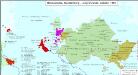
Mecklenburg und angrenzende Gebiete 1812
Mecklenburg-Strelitz, Mecklenburg-Schwerin Hundt, Michael
Hansestädte, Mecklenburg und angrenzende Gebiete 1871
Mecklenburg-Strelitz, Mecklenburg-Schwerin, Hansestadt Kunz, Andreas ; Moeschl, Joachim Robert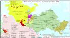
Hansestädte, Mecklenburg und angrenzende Gebiete 1848
Mecklenburg-Strelitz, Mecklenburg-Schwerin, Hansestadt Kunz, Andreas ; Moeschl, Joachim Robert
Hansestädte, Mecklenburg und angrenzende Gebiete 1820
Mecklenburg-Strelitz, Mecklenburg-Schwerin, Hansestadt Hundt, Michael
Hansestädte, Mecklenburg und angrenzende Gebiete 1814
Mecklenburg-Strelitz, Mecklenburg-Schwerin, Hansestadt Hundt, Michael
Saxonia Inferior [Karte], in: Novus atlas absolutissimus, Bd. 2, S. 27.
1 Karte aus Atlas Janssonius Offizin
Hannover and Brement: billeting and control facilities for displaced persons (Section B)
Germany. Zones of Occupation 1947. (Greater Berlin. Scale 1: 199,000).
Die Grossherzogthümer Mecklenburg-Schwerin und Mecklenburg Strelitz, den Herzogthümern Holstein und Lauenburg, den Herzogl. Oldenburgischen Fürstenthume Lübeck und den Gebieten der freien Staedte Hamburg und Lübeck / entworfen von C.F. Weiland
1 : 550000 Weiland, C. F. Weimar : Verlag des Geograph. Instituts
Dvcatvs Lvnebvrgensis Adiacentiumq; regionum delineatio
1 : 480000 Mollova mapová sbírka Aveele, Johannes van den Schenk, Peter I
Karte des Herzogthums Mecklenburg mit seinen verschiedenen Provinzen ... / durch F.W.C. Grafen von Schmettau
1 : 250000 Schmettau, F. W. C. von Berlin : [s.n.]
L' Electorat de Hannover
1 : 560000 Mollova mapová sbírka Lotter, Tobias Conrad Lotter, Tobias Conrad
Ducatus Luneburgicus cum Comitatu Dannebergensi juxta Praefecturas suas accurrate designatus et mappa Geographica
1 : 330000 Mollova mapová sbírka Seutter, Matthäus Seutter, Matthäus
Ducatus Luneburgici et Dannebergensis Comitatus
1 : 330000 Mollova mapová sbírka Wit, Frederik de Covens, Johannes I
Ducatus Luneburgici et Comitatus Dannebergensis accurata Descriptio
1 : 360000 Mollova mapová sbírka Homann, Johann Baptist Homann, Johann Baptista
![Saxonia Inferior Et Meklenborg Duc: [Karte], in: Gerardi Mercatoris et I. Hondii Newer Atlas, oder, Grosses Weltbuch, Bd. 1, S. 271.](https://images-0.georeferencer.com/images/iiif/210610569037/full/,300/0/native.jpg)

