Maps of Ukraine
Polonia Et Ungaria XX. Nova Tabula. [Karte], in: Claud. Ptolemaeus. Geographia lat. cum mappis [...], S. 422.
1 Karte aus Atlas Münster, Sebastian [und Ptolemaeus, Claudius]
Polonia Et Ungaria, XV. Nova Tabula. [Karte], in: Claud. Ptolemaeus. Geographia lat. cum mappis [...], S. 398.
1 Karte aus Atlas Münster, Sebastian [und Ptolemaeus, Claudius]
Polonia Et Ungaria, XV. Nova Tabula. [Karte], in: Geographia universalis vetus et nova complectens Claudii Ptolemaei Alexandrini enarrationis libros VIII, S. 338.
1 Karte aus Atlas Münster, Sebastian [und Ptolemaeus, Claudius]
Charte von Ungarn, den russisch- oesterreich- und presussischen- Besitzungen im ehemal. Polen, ingl. dem Schwarzen meer und der Türkey
1 : 4160000 Evropa jihovýchodní Utz, Georg Friedrich Anville, Jean-Baptiste Bourguinon d' Kunsthandl. A.G. Schneider u. Weigels
Landtafel des Ungerlands, Polands, Reüssen, Littaw, Walachei und Bulgarei
1 : 4800000 1 Karte : Holzschnitt ; 26 x 34 cm Münster, Sebastian [Bey den Henricpetrinischen]
Landtafel des Ungerlands, Polands, Reüssen, Littaw, Walachei und Bulgarei
1 : 4800000 1 Karte : Holzschnitt ; 26 x 34 cm Münster, Sebastian [Bey den Henricpetrinischen]
Svět staroslovanský
Evropa střední a východní Milbauer, Emanuel Vlastimil Šafařík, Pavel Josef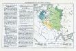
Die Teilung Polens und seine spätere Entwicklung
Polen Teilungen Polens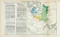
Nr. 15. Die Teilung Polens und seine spätere Entwicklung
Polen Teilungen Polens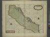
A sea chart of the Gulph of VENICE describing all the sea coasts and Islands contained therein
from The sea-atlas : containing an hydrographical description of most of the sea-coasts of the known parts of the world.
Die Länder des Grössten Völkergemisches
1 : 20000000 Ostmitteleuropa, Südosteuropa
Polska za Władysława Łokietka roku 1333
Evropa jihovýchodní
Lechia za Bolesława Wstydliwego roku 1279
Evropa jihovýchodní
Polska czyli Lechia od Bolesława Krzywoustego między synów podzielona roku 1139
Evropa jihovýchodní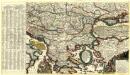
Mappa Generalis Danubii Principatum ab origine usque ejus influx um in mare nigrum
Mollova mapová sbírka Lidl, Johann Jakob
Troisième partie de la carte d'Europe contenant le midi de la Russie, la Pologne et la Hongrie, la
1 : 2900000 1 Karte auf 2 Blatt : Kupferdruck ; 52 x 82 cm Anville, Jean Baptiste Bourguignon d' chez l'auteur au galeries du Louvre
Carte des Etats de la Covronne de Pologne
1 : 3000000 Mollova mapová sbírka Mayer, Tobias Homann, Johann Baptista - dědici
Polska za Stefana Batorego roku 1586
Evropa jihovýchodní
Polska za Mieczysława I. roku 992
Evropa jihovýchodní
Polska za Kazimirza Wielkiego roku 1370
Evropa jihovýchodní
Sławiańszczyzna przed powstaniem Polski roku 850
Evropa jihovýchodní
Polska za Jana Alberta roku 1500
Evropa jihovýchodní
Polska za Jana Kazimirza i za Michała Wisniowieckiego 1673, klęski od roku 1648 do 1717
Evropa jihovýchodní
Polska za Zygmunta Augusta roku 1572
Evropa jihovýchodní
Polska za Stanisława Augusta podzielona 1772, 1793, 1795
Evropa jihovýchodní
Polska za Bolesława Wielkiego roku 1025
Evropa jihovýchodní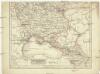
Eur. Russland
Rusko jižní
Le Royaume De Hongrie, et les Estats qui en ont esté sujets, et qui sont preventement La Partie Septentrionale De La Tourquie En Europe [Karte], in: Atlas nouveau, contenant toutes les parties du monde [...], Bd. 2, S. 197.
1 Karte aus Atlas Sanson, Nicolas Jaillot, Alexis Hubert und Mortier, Pieter
Polen vom Anfange des XVIII Jahrhunderts bis zum Untergange der Republik 1795
1 : 5000000 Polen-Litauen, Teilungen Polens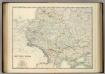
![Polonia Et Ungaria XX. Nova Tabula. [Karte], in: Claud. Ptolemaeus. Geographia lat. cum mappis [...], S. 422.](https://images-2.georeferencer.com/images/iiif/457572974366/full/,300/0/native.jpg)

